Manuscript of the Month: Grafton Street (WSC/Maps/564)
Published on 9th October 2017
 This map is what we would now call the development plan for what became Grafton Street. The plan is by the Dublin City Surveyor, John Greene, to the scale of 10 feet to an inch and it is dated 17 January 1680. At that date, Grafton Street was a humble country lane, linking the two open spaces of St Stephen’s Green and Hoggen Green. There was even a municipal dung-heap, known as ‘The Pound’ at the end of the lane. The Dublin City Assembly’s plan envisaged a new street to be 46 feet wide, with removal of The Pound. As yet the new thoroughfare had not got a name – it would eventually be called after the Duke of Grafton, an illegitimate grandson of Charles II.
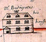
There are two aspects of particular interest in this map. The first is ‘Mr Burnyates’ House and Garden’ which was situated roughly where Marks and Spencer is today. Thomas Burnyates was a Quaker merchant and his house – really it was more like a three-storey mansion – was built in the cage-work style which was so popular in Dublin in the late 16th century. These cage-work houses were stoutly built from Irish oak and the last surviving specimen, at the corner of Castle Street and Werburgh Street, was demolished by order of the Wide Streets Commission in 1812.
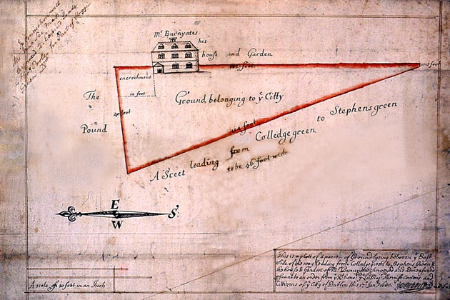
WSC Map 564 East side of Grafton Street, 1680.
The second point of interest is the compass pointer. The present convention, whereby the compass points north to the top of the map, came into being in the mid-18th century. Before that, the cartographer could select his own direction. Here, John Greene is showing north to the left hand side of the map with south to the right; east is to the top and west to the bottom.
This map was appropriated by the Wide Streets Commission to facilitate its work on Grafton Street in the early 19th century – this explains its WSC reference number. A note also regarding the date: the British Isles had not adopted the Gregorian Calendar but remained with the Julian Calendar, where new year’s day took place on 25 March. The date given on the map, January 1680, would therefore read January 1681 under present-day conventions.
Manuscript of the Month
Each month, Dublin City Archives will be showcasing a manuscript from their collections on our blog. Check back next month for the next instalment!