Dublin City and Dublin Agglomeration Strategic Noise Maps
Strategic Noise Mapping for Dublin
Legal background
The Environmental Noise Directive, known as the END, and the European Communities (Environmental Noise) Regulations 2018 to 2021 require Strategic Noise Maps to be prepared for the Dublin agglomeration.
The maps cover the following noise sources:
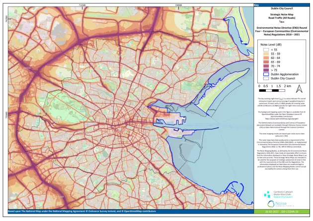
- Road traffic, including all roads and major roads
- Railway traffic, including all railways and major railways
- Aircraft noise from major airports
- Industrial noise, including ports
Area covered by the maps
Strategic Noise Maps for road, rail, and industry are provided for Dublin City Council’s administrative area and for the full Dublin agglomeration.
Noise indicators used in the maps
The Strategic Noise Maps present noise levels using two indicators, in line with the requirements of the Regulations.
Lden: day, evening and night level
Lden is a noise indicator used to assess overall annoyance. It is based on the annual average sound level over a full 24-hour period, using A-weighted sound levels.
The following adjustments are applied:
- An additional 5 decibels for evening noise between 7.00 pm and 11.00 pm
- An additional 10 decibels for night-time noise between 11.00 pm and 7.00 am
Lden noise levels above 55 decibels are required to be reported to the European Commission.
Lnight: night level
Lnight is a noise indicator used to assess potential sleep disturbance. It is based on the annual average sound level during the night-time period, from 11.00 pm to 7.00 am.
Lnight noise levels above 50 decibels are required to be reported to the European Commission.
Noise contours shown on the maps
Only noise levels that meet or exceed the reporting thresholds are shown on the maps.
- Noise contours are shown in steps of 5 decibels
- No contours are shown for noise levels below the reporting thresholds
How the maps were produced
The noise contours are not based on on-site measurements. They are produced using computer noise modelling.
The modelling follows a common noise assessment methodology adopted by the European Commission, in line with Article 6.2 of Directive 2002/49/EC and Commission Directive (EU) 2015/996.
This methodology is known as CNOSSOS, which stands for Common Noise Assessment Methods in Europe.
Changes in methodology
CNOSSOS has been used for the first time in Round 4 of Strategic Noise Mapping. Rounds 1 to 3 used a different recognised methodology available at that time.
Due to changes in modelling methods and input data, direct comparisons between Round 4 maps and maps from previous rounds should be made with caution.
Purpose of the Strategic Noise Maps
The Strategic Noise Maps are used to:
- Provide noise data to the European Commission in accordance with the Environmental Noise Directive
- Provide information to the public about environmental noise and its effects
- Support the development of Noise Action Plans by identifying noise priority areas, quiet areas, and potential mitigation measures
Appropriate use of the maps
The Strategic Noise Maps show predicted noise levels for each noise source across a given area.
They should not be used to determine noise levels at specific locations for:
- Planning applications
- Enforcement of noise-related planning conditions
- Environmental Impact Assessments
These purposes require detailed noise assessments, including on-site monitoring at relevant locations.
Accessing the maps
The Strategic Noise Maps for Dublin City and the Dublin agglomeration can be downloaded using the links provided below.
The maps can also be viewed on the Environmental Protection Agency map website.
Visit the Environmental Protection Agency map site
A guide explaining how to view the maps is also available for download below.
Dublin City Council Strategic Noise Maps
Dublin Agglomeration Strategic Noise Maps