Dublin City Council Transport Plan FAQs
The first of the measures contained in the adopted Dublin City Transport Plan 2023 will come into effect from the 25th of August 2024.
Why are these measures being implemented?
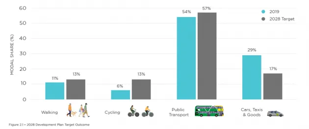
These traffic management measures are being implemented to meet the policies and objectives of the Dublin City Development Plan 2022 – 2028. This includes meeting the mode share targets set out in the Dublin City Development Plan 2022 – 2028 (the figure shows walking to increase from 11% mode share in 2019 to 13% in 2028; cycling to increase from 6% mode share in 2019 to 13% in 2028; public transport to increase from 54% mode share in 2019 to 57% in 2028; cars, taxis and goods to reduce from 29% mode share in 2019 to 17% in 2028).
The measures on the north and south quays are the first measures from the Dublin City Transport Plan 2023 that aim to begin to meet this target. These measures set to address the 60% of general traffic in the city centre that is not stopping, working or shopping but is travelling through the city.
On the north quays between 7am and 7am, just 2% of the users at the Bachelors Walk/O’Connell Bridge/O’Connell Street junction are undertaken by people in cars. However at least 50% of the road space is assigned to cars. This is causing delays to the existing public transport network, particularly buses which account for 49% of the users at this junction. As creating additional road space is not an option, the existing space needs to work as efficiently as possible by moving the most amount of people whilst still maintaining access for businesses, residents and deliveries.
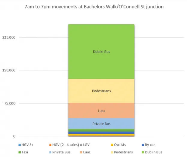
The figure shows there are 252,000 movements at the Bachelors Walk/O’Connell Street junction between 7am and 7pm. These are made up of:
- Dublin Bus , 123,885 users, 49% of total movements
- Pedestrians 54,469 users, 22% of total movements
- Luas, 34,750 users, 14% of total movements
- Other Bus 24,605 users, 10% of total movements
- Taxi, 6,141 users, 2.4% of total movements
- By car, 4,724, users, 2% of total movements
- Cyclists, 4,025 users, 2% of total movements
- LGV, 1,499 users, 0.6% of total movements
- HGV (2 - 4 axles), 233 users, 0.1% of total movements
- HGV 5+, 68 users, 0.03% of total movements
The measures on the north quays, which will affect approximately 200 users an hour (0.08% of all users each day), will allow for more space to be allocated to public transport initially which will improve the reliability, speed and service for public transport.
Similarly, on the south quays between 7am and 7am, just 2% of the users at the Burgh Quay O’Connell Bridge/Aston Quay junction are undertaken by people in cars. However at least 50% of the road space is assigned to cars. This is causing delays to the existing public transport network, particularly buses which account for 50% of the users at this junction. As creating additional road space is not an option, the existing space needs to works as efficiently as possible by moving the most amount of people whilst still maintaining access for businesses, residents and deliveries.
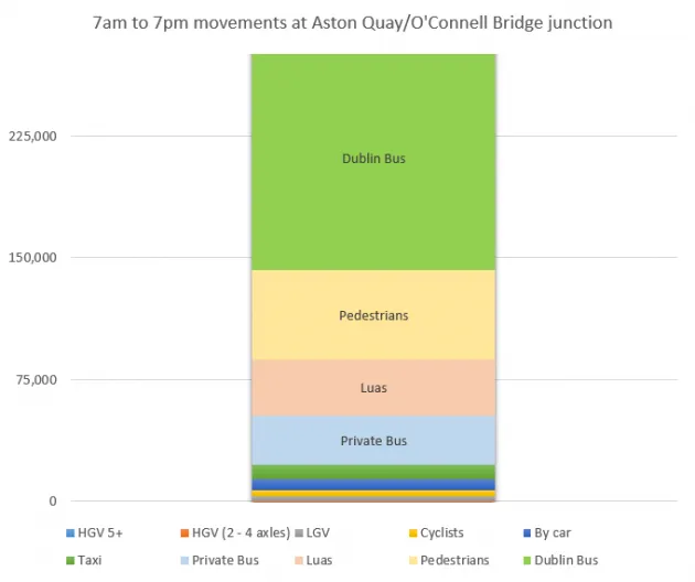
The figure shows there are 277,000 movements at the Bachelors Walk/O’Connell Street between 7am and 7pm. These are made up of:
- Dublin Bus, 137,970 users, 50% of total movements
- Pedestrians 54,921 users, 20% of total movements
- Luas, 34,750 users, 14% of total movements
- Other Bus 30,240 users, 11% of total movements
- Taxi, 8,844 users, 3.2% of total movements
- By car, 4,724, users, 2% of total movements
- Cyclists, 3,993 users, 1.4% of total movements
- LGV, 2,374 users, 0.9% of total movements
- HGV (2 - 4 axles), 372 users, 0.1% of total movements
- HGV 5+, 44 users, 0.02% of total movements
The measures on the south quays, which will affect approximately 390 users an hour (0.1% of all users each day), will allow for more space to be allocated to public transport initially which will improve the reliability, speed and service for public transport.
On the 25th August 2024, traffic management measures are being implemented on the north quays at Bachelors Walk and on the South Quays on Burgh Quay and Aston Quay. These changes consist of road marking and signage changes. All other routes on the quays and all other routes in the city remain the same and North-South, South-North access to all Liffey Bridges will remain the same.
The hours of operation for these new restrictions will be 7am to 7pm Monday to Sunday. Outside these hours the restrictions will not be in operation and all vehicles can travel as before.
The traffic management measures on the north quays commence after the existing bus gate on Bachelors Walk. There are no changes before this area.
General traffic can continue to travel along the north quays and Bachelors Walk as far as O’Connell Street but will not be permitted to continue onto Eden Quay .
- The straight ahead movement Bachelors Walk to Eden Quay will be for public transport, taxis and cyclists only. The right turn movement to O’Connell Bridge will continue to be Public Transport, taxis and cyclists only as it is at present.
- General traffic can use Bachelors Walk to access the length of Bachelors Walk but must turn left at O’Connell Bridge i.e. there is no straight or right turn permitted.
- Vehicles using Bachelors Walk will be channelled to the left hand side after the bus signals at Litton Lane and will have to turn left at O’Connell Bridge, no other movement is permitted.
- The existing bus stop which currently serves tour buses will be removed.
- The disabled bay, loading and taxi space on Bachelors Walk will remain.
- There will be no straight ahead movement permitted from Bachelors Walk to Eden Quay for general traffic and the existing prohibition on turning left from O’Connell Street to Eden Quay remains.
- The right turn from O’Connell Bridge to Eden Quay will be changed to include general traffic rather than public transport as it is at present, this will allow access to Eden Quay for deliveries etc.
- Taxis and cyclists will be permitted to use the bus lanes at all times.
- Further east of O’Connell Street (ie Custom House Quay, North Wall Quay) will remain the same.
The changes commence east of O’Connell Bridge on Burgh Quay. There are no changes before this area.
General traffic can continue to travel along the south quays and Burgh Quay as far as O’Connell Bridge but will not be permitted to continue straight onto Aston Quay.
- The straight ahead movement from Burgh Quay to Aston Quay will be Public Transport, Taxis and cyclists only.
- All vehicles can turn left from Burgh Quay to D’Olier Street as at present.
- All vehicles can turn right from Burgh Quay to O’Connell Bridge as at present.
- The left turn from Westmoreland Street to Aston Quay will be Public Transport, Taxis and cyclists only.
- The left turn from Westmoreland Street to Fleet Street will be for deliveries and access only.
- Access to the Temple Bar area for deliveries etc. will be from the Westmoreland Street turn to Fleet Street, as will access to Fleet Street carpark, the disabled bay on Aston Quay or to be dropped off on Aston Quay, this will be possible via Fleet Street.
- Further west of Parliament Street (ie Wood Quay, Usher’s Quay, Merchants Quay) will remain the same.
There are no changes to disabled bays.
- The disabled bay on Bachelors Walk remains in the same location and is accessible via Bachelors Walk as it is currently.
- The disabled bay on Eden Quay remains in the same location and is accessible via the south quays (Burgh Quay) – right onto O’Connell Bridge and a right turn onto Eden Quay which is reopening for all traffic
- The disabled bay on Aston Quay remains in the same location and is accessible via the south quays (Burgh Quay) – left onto D’Olier Street – right onto Westmoreland Street – left onto Fleet Street – right onto Princes lane – left onto Aston Quay.
Access to existing properties will be maintained although there may be a different route to or from the area if the current route is affected by the new measures.
If you have a specific query about access contact [email protected]
There are no changes to taxi ranks in the area and taxis are permitted to use the bus lanes at all times.
There are no changes to loading bays in the area.
- The loading bay on Bachelors Walk remains in the same location and is accessible via Bachelors Walk as it is currently.
- The loading bay on Eden Quay remains in the same location and is accessible via the south quays (Burgh Quay) – right onto O’Connell Bridge and a right turn onto Eden Quay which is reopening for all traffic
- The loading bay on Aston Quay remains in the same location and is accessible via the south quays (Burgh Quay) – left onto D’Olier Street – right onto Westmoreland Street – left onto Fleet Street – right onto Princes lane – left onto Aston Quay.
- Loading into the Fleet Street/Temple bar area remains as it is currently.
- Loading into the O’Connell Street, Middle Abbey Street, North Lotts area remains as it is currently.
If you have a specific query about deliveries or access contact [email protected]
The vast majority of routes to hospitals will remain the same. For example those accessing the Rotunda, Temple Street Hospital or the Mater via the north quays will still be able to do so and can continue to travel the north quays along Bachelors Walk, left into O’Connell Street and take the same route as is currently the situation. Alternative routes via Jervis Street or Church Street are also available. Access from the north and west of the city remains the same also.
Those accessing St James Hospital from the north east of the city (eg Clontarf) will still be able to do so via North King Street and Church Street. Those coming from the north, south and west of the city will be unaffected.
If you have a specific query about deliveries or access contact [email protected]
Note that we are working with the various mapping companies so that the new measures will be taken into account when undertaking a journey.
The majority of routes to city centre carparks remain the same. Between 7am and 7pm the route to:
Fleet Street carpark – via the south quays. Travel along Burgh Quay, left onto D’Olier Street, Right onto Westmoreland Street, left into Fleet Street. Exit remains the same.
South City Carparks – access from the south and west of the city remains the same.
Those who currently access these carparks via Aston Quay will be able to access carparks in those areas via North King Street and Church Street or via Memorial Bridge and St Stephens Green.
North City Carparks – Access from the north remains the same. Access from the west and south remains largely the same with access along the north quays as far as O’Connell Bridge. For carparks further east access is available from the west and south west via Church Street and Dorset Street and from the south east via Butt Bridge.
Yes, they are. Motorcycles are private vehicles and not, therefore, permitted to use bus or cycle lanes.
No, there are no exemptions. Only public transport, cyclists, taxis and emergency vehicles can use them.
No, they are not. Only public transport, cyclists, taxis and emergency vehicles can use them.