Gracefield Road to Vernon Avenue Active Travel Scheme
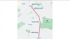
This scheme aims to enhance walking and cycling routes along a 2.6km stretch of road as part of Dublin City Council's Active Travel programme. This scheme is currently at the Detailed Design and Procurement phase.
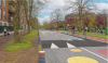
Gracefield Road, Brookwood Avenue, Sybill Hill Road and Vernon Avenue have been identified as suitable roads for walking and cycling Active Travel measures. This scheme will deliver protected cycling facilities in both directions and numerous improvements for pedestrians over a 2.6km route.
This scheme will form part of Dublin City Council's Active Travel Network. To understand how this scheme fits into the planned 314km network, you can view our interactive GIS map.
Additionally, following on from site investigations which took place in Q1 2025, further changes to the entire Gracefield Road to Vernon Avenue route have been made, taking into consideration the concerns from all key stakeholders including the community and Elected Members.
A non-statutory public consultation was held in July and August of 2023 to obtain the public’s views of the proposed scheme. A follow up public information event was held in September 2024. Following on from site investigations which took place in Q1 2025, further changes to the entire Gracefield Road to Vernon Avenue route have been made, taking into consideration the concerns from all key stakeholders including the community and Elected Members.

Learn More About This Scheme
Key Changes
Key features of the Gracefield Road to Vernon Avenue Active Travel scheme include:
- Protected cycle tracks for 2.6km along the route with one-way cycle tracks on Gracefield Road and a two-way cycle track on the western side along Brookwood Avenue, Sybill Hill Road and Vernon Avenue
- The existing Howth Road signalised junction will be upgraded to a protected cycle-friendly junction. The new junction design will maintain the right pocket turn lanes. The design will ensure the junction can continue to operate efficiently and allow safe passage for people walking and cycling through the junction
- New School Zones will be introduced next to St. Brigid’s Boys National School and St. Paul’s College on Sybill Hill Road. The School Zones will include pencil shaped steel bollards and colourful road markings to highlight the presence of the school and prevent parking on pavements
- The Seafield Road / Vernon Avenue junction will be improved by removing the vehicle left slip. Removal of the slip will have a negligible impact on traffic congestion, whilst greatly increasing safety for pedestrians and cyclists
- A number of the smaller priority and signalised junctions along the route will be upgraded to include toucan crossings, tightened corner radii and additional space for right turning cyclists. The designs also include raised tables, as well as continuous footpaths and cycle tracks across side roads where applicable
The main aim of this scheme is to provide an attractive, cohesive, direct, comfortable and safe environment to encourage walking and cycling. The scheme will provide quality, protected cycling facilities to cater for all ages and abilities.
This will facilitate a more active lifestyle for everyone bringing multiple benefits for physical and mental wellbeing. It will also contribute to a reduction in transport emissions in line with the objectives of the Government's Climate Action Plan by encouraging Active Travel.
This scheme will be part of Dublin City Council's Active Travel Network. It will provide a link into adjacent Active Travel and public transport schemes including:
- Harmonstown Dart Station.
- Bus Connects: D and H Spines.
- The East Coast Trail Active Travel Scheme.
- The Baldoyle to Fairview Active Travel Scheme.
- Vernon Avenue to Clontarf Road Active Travel Scheme
- Ardlea Road to Oscar Traynor Road Scheme
The scheme will also improve links to St. Anne’s Park, numerous other community amenities and numerous education centres.