4.15.2 Dublin Tree Canopy Research Study
4.15.2 Dublin Tree Canopy Research Study
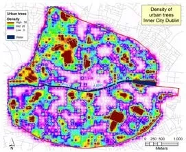
The Dublin Local Authorities and the Office of Public Works commissioned the School of Geography at University College Dublin to map the distribution of the tree canopy within County Dublin, following earlier research carried out independently by the university on the city centre area.
In addition to mapping the canopy, the study also analyses its distribution with regard to land use, potential environmental services and presents a comparison with other European cities. This study will allow strategic targets to be set to increase the percentage tree canopy cover in Dublin and how Parks Services can contribute to this with public tree planting.