Finglas to Killester Active Travel Scheme
This Active Travel scheme will provide 10km of walking, wheeling and cycling facilities. It is currently at the Concept Development and Option Selection phase.
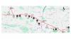
This new scheme enhances walking and cycling facilities for approximately 10 km from Finglas in the north west of Dublin to Killester in the north east.
Additionally, it will connect Finglas, Ballymun, Glasnevin, Whitehall, Beaumont, Donnycarney and Killester to destinations like DCU, St. Anne’s Park and numerous public transport interchanges.
This scheme is part of Dublin City Council's Active Travel Network. To understand where this scheme fits into the citywide network, view our interactive GIS map.
Primarily the route connects Finglas Village in the west to Killester Village in the east. However, the scheme also includes a 1.2km route north of Finglas Village. This will connect with the proposed Finglas Village Improvement Scheme, which is at a more advanced stage of development.
This route starts at the junction of McKelvey Avenue and Saint Margaret’s Road, and proceeds south along Saint Margaret’s Road before connecting to Finglas Village at McKee Avenue.
Moving from west to east, the route commences in Finglas West at the junction of Cappagh Road and Ratoath Road and moves east along Cappagh Road and Mellowes Road meeting the Finglas Village Improvement Scheme. The route then continues east along Ballygall Road West, Glasnevin Avenue, Collins Avenue and Collins Avenue East as far as Killester Village. The scheme then turns north east onto the Howth Road, before turning east again onto Furry Park Road. The route ends at the junction of Vernon Rise and Sybill Hill Road.