Sandyford Clonskeagh to Charlemont Street Active Travel Scheme
Dublin City Council plans to provide 3km of safer walking, wheeling and cycling facilities from Clonskeagh Road to Charlemont Street. The first stage of this scheme, which has introduced interim measures along the route, is complete (except for some snagging works).
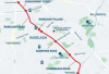
This scheme will provide 3km of high-quality walking, wheeling and cycling facilities, along with significant public realm upgrades, from Clonskeagh Road to Charlemont Street. The route extends from the River Dodder along Sandford Road, Ranelagh, Ranelagh Road and Charlemont Street to the junction of Harcourt Road.
The Sandyford Clonskeagh to Charlemont Street (SC2C) Active Travel Scheme is a primary route in the Greater Dublin Area Cycle Network Plan and forms part of Dublin City Council's Active Travel Network. You can see where this scheme fits into the citywide network by viewing our interactive GIS map.
The SC2C scheme will be delivered in two stages. The Ranelagh Village Interim Scheme has been delivered in 2025 to facilitate the early implementation of safety measures. The Permanent Scheme will be delivered in three phases between 2026 and 2029.


Learn More About This Scheme
- To facilitate the delivery of the Greater Dublin Area Cycle Network Plan by providing continuous, segregated cycling facilities from Clonskeagh to Charlemont Street.
- To contribute to an increase in cycling along the corridor by improving access to key education, employment, retail and transport destinations. For example, the scheme links UCD to the south city centre where St. Stephens Green, RCSI and Trinity College are located. The route will also serve local schools such as Sandford Parish National School, St. Mary’s National School, Sandford Park School, Gonzaga College SJ and Muckross Park.
- To reduce the risk of cyclist collisions through segregation from traffic, where possible.
- To encourage increased levels of physical activity and leisure along the corridor through provision of a safe, high-quality and attractive route for both cyclists and pedestrians.
- To enhance quality of life by improving connectivity and sustainable mobility while reducing transport-related carbon emissions.
The SC2C scheme will be delivered in two distinct stages. The interim scheme has been delivered in 2025 and the permanent scheme will be delivered between 2026 and 2029.
This approach has the benefits of:
- Implementing improved safety measures earlier.
- Having flexibility to do minor alterations to the layout if needed before the permanent scheme is constructed.
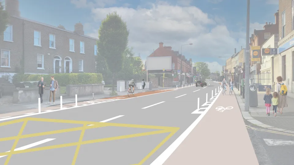
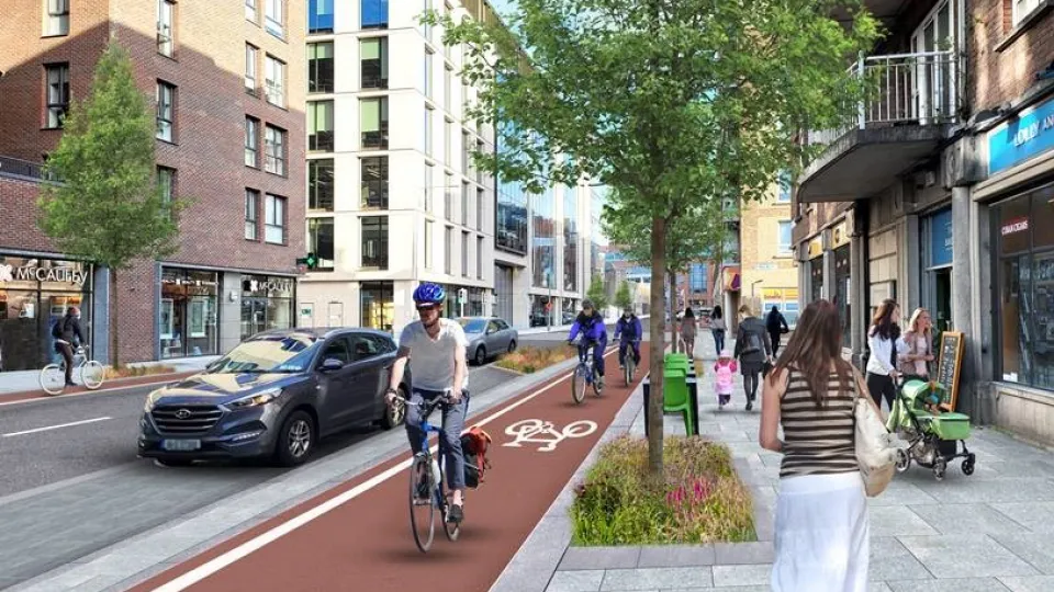
The interim scheme will provide continuous segregated cycle tracks mainly using bollards and road markings.
Our experience from implementing other walking and cycling schemes indicates that the provision of segregated cycling facilities usually results in a modal shift away from cars and towards Active Travel. With more people opting to use sustainable modes of transport, road traffic will ultimately decrease, improving the safety of the route for all.
Additionally, parking is a major traffic generator. The removal of parking spaces along the route should decrease traffic levels and help with traffic congestion as it becomes less attractive to drive into the area. Generally improved and safer facilities for Active Travel options will provide a positive improvement for the area.
Evidence from recent schemes in the city suggest that initial disimprovements are alleviated over time as road users adjust their travel pattern.
Due to insufficient lane width to provide traffic lanes, cycle lanes and bus lanes, the current design proposal includes the removal of two short stretches of bus lane. This includes 250 metres along Ranelagh Road and 200 metres along Charlemont Street.
These bus lanes are not continuous and bus traffic is low with a frequency of approximately every 15 minutes. Improvements in Active Travel measures typically encourage a switch to Active Travel modes of transport, which results in less vehicle traffic on the route. The removal of car parking spaces will also reduce kerbside activity and provide an increase throughput available for bus journeys.
With consideration of the above changes, it is expected that there will not be a significant impact on bus times. Island bus stops are proposed at the majority of bus stop locations along the route.
It is envisaged that 18 trees will be removed and replaced with 38 new trees. This means there will be an increase in the number of trees on the route.
More details on the tree planting and removal can be found in the planning drawings.
There will be an reduction of 60 parking spaces along the 3km route. The number of disabled parking bays will be retained.
The current provision of taxi spaces on both sides of Cullenswood Road / Ranelagh Triangle will remain. It is proposed that the existing taxi bay/time-plated parking bay on the south side of Cullenswood Road will be reduced from 19.5 metres in length to 13 metres to allow for the installation of a disabled parking bay.
It is proposed to provide additional bike parking where space permits throughout the scheme. Details of these locations will be determined as the scheme progresses.
The proposed scheme will enhance the look and feel of Ranelagh Village by slowing traffic through narrowing the road, the provision of segregated cycle tracks, renewed footpaths, reduced crossing distances and pedestrian priority at side roads.
All of these developments will encourage more people to walk, wheel and cycle to and from local businesses and will make the shopping experience more inviting. The proposed scheme aims to make the area safer and more accessible, which would make the experience of walking and cycling to local businesses more enjoyable.
Increasing the size of the public realm area where Cullenswood Road meets Ranelagh Village coupled with the addition of more planters and trees will encourage people travelling through Ranelagh to stop and spend time and money in local businesses. The existing benches in this area will also be retained. Additional bike parking at the public realm area will further facilitate this. Currently, the existing bike parking is well utilised.
Details of the type of material finishes proposed can be viewed in our planning drawings.
A survey of the loading bays along the route has been undertaken and a loading strategy that will facilitate deliveries to the businesses is at an advanced stage. There is ongoing engagement with local businesses in relation to loading provision.
The footpaths along the entire route will be upgraded as part of the permanent scheme, This will include significant public realm improvements.