Drone Unit Overview
The Drone Unit is the central point for all drone (UAS) related requests within Dublin City Council administrative area.
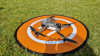
Dublin City Council has been using drones since 2017. Drones are proving to be very beneficial to the organisation: reducing cost, saving time and improving the safety of the staff and operations.
In 2023, it was recognised that Dublin City Council would need a Drone and Urban Air Mobility Strategy to coordinate the development of drone services within the organisation, as well as provide a support with an emerging Urban Air Mobility- the move of the goods and people across our city. Drone and Urban Air Mobility Strategy 2024-2029 was launched in May 2024. A core element of the strategy was to create a dedicated Drone Unit. The Drone Unit was set up in June 2024 within Survey and Mapping Division which has a team of pilots with the highest level of expertise within the organisation in relation to drone operations. This unit is serving as the focal point for strategic planning, manages the complexity of issues relating to drone operations both internally and externally, and ongoing innovation in drone technology. By centralizing expertise and resources, the Drone Unit aims to streamline operations, ensure compliance with regulations, and drive forward the adoption of emerging technologies in drone operations. Drone Unit’s expertise will scale in line with the demands of increased use of drone services across the organisation and the evolution of the technical and regulatory landscape, with the aim of the Unit to be a leading centre of excellence for local authority drone services.
For more information please email: [email protected]


Watch the videos below to discover how DCC is using drones across multiple departments and the impacts drones have made on our city services.
- Short video: DCC drones use cases_short version
- Longer video: DCC drones use cases_long version
Video overview content:
Survey & Mapping Division uses drones to support projects, carry-out inspections, for an asset management, to produce videos, 3D models and orthophoto maps. Drones enhance safety by removing the need for staff to access hazardous areas and ensure fast, efficient responses across departments.
Flood Defence Projects Office – the team uses drones to inspect critical infrastructure efficiently and safely (e.g. Fitzwilliam Quay and the 12th-century Islandbridge Weir). Drones are becoming vital for safeguarding both historic sites and flood-prone areas, ensuring community safety while reducing costs.
Dangerous Buildings Section - inspectors are using drones to safely assess structural damage, eliminating the need for scaffolding or cherry pickers. This approach minimizes risk, reduces costs, and speeds up response times in hazardous situations.
Active Travel and Urban Mobility - drones are assisting with large scale projects, such as the Clontarf to City Centre Project (C2CC), supporting project oversight by capturing progress updates and visuals to inform decision-makers. This technology is a key enabler for modern urban mobility projects.
Dublin Fire Brigade - firefighters use drones for real-time aerial insights, 3D mapping of high-risk sites, and pre-incident planning. This technology enhances safety, improves efficiency, and strengthens emergency preparedness.
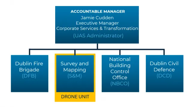
The current DCC drone operations structure has four sections registered with the IAA, including Dublin Fire Brigade, Survey & Mapping with the new corporate Drone Unit, National Building Control Office and Dublin Civil Defence. Jamie Cudden, Executive Manager for Corporate Services & Transformation, is the overall accountable manager. With a new corporate focus and the addition of a number of new dedicated roles to manage and deliver drone services it will enable the unit to support other sections seeking to apply drones within their services.
Drone Unit has qualified remote pilots operating in Open category ( DJI Mini 3, DJI Mini 4 and DJI mini 5 drones) as well as in Specific category under SORA (DJI Mavic 3E).
The DCC Drone Unit competencies:
- Operations
- Shared Services: The Drone Unit provides drone services for other DCC sections as demand grows and maintain relationships with other registered DCC drone operators (DFB, NBCO and DCD).
- Centralised Management of Drone Equipment: The Drone Unit is responsible for researching and then purchasing relevant drone hardware including base flight units and relevant accessories (e.g. LIDAR/Camera/sensors).
- Regulatory Knowledge: Drone Unit staff keeps up to date with all State and EU regulations with regard to safe flying, drone & pilot registration, submission of mandatory documentation to the IAA as well as providing advice to other DCC Departments/ Sections.
- Training and Skills: Staff within the unit maintains training standards and ensure minimum flying hours are logged (as per EU regulation).
- Procurement: The Drone Unit is responsible for procuring and maintaining Framework Agreements for pilot training and consultancy work around registration and conducting operations with the IAA. Where external surveying drone services are required, the Unit will develop a framework so various departments can easily access the services.
- Centre of Excellence: The corporate Drone Unit is at the centre of all drone operations for DCC carrying out flight missions, offering advice and technical assistance to all Departments/Sections within DCC.
-
Expertise: The section is staffed by colleagues who are fully trained and qualified as remote pilots in accordance with the relevant State and EU regulations.
2. Governance & Policy:
- Governance: The Drone Unit will be responsible for the implementation of all State and EU Regulations. The Unit will operate under the High-Level Drone Steering Group (comprising members of the DCC Senior Management Team) and will be responsible for the development of operational terms and conditions for all DCC drones services.
-
Policy Support: Keeping up to date on international best practice and industry development to inform city policy.
3. Innovation
- Ecosystem Co-ordination and Collaboration: The Drone Unit in partnership with the Smart Cities Unit will co-ordinate relationships within DCC and external bodies such as universities, IAA, consultants and other drone services providers to share best practices and identify new opportunities for collaboration.
| Abbreviation | Full Term |
|---|---|
| AAM | Advanced Air Mobility |
|
BVLOS DAU |
Beyond Visual Line of Sight Data and Analytics Unit |
| DCD | Dublin Civil Defence |
| DCC | Dublin City Council |
| DFB | Dublin Fire Brigade |
| DIP | Drone Innovation Partnership project |
| Drone | Common name for Unmanned Aircraft System (UAS), which means an Unmanned Aerial Vehicle (UAV) and the equipment to control it remotely |
| EASA | European Union Aviation Safety Agency |
| eVTOL | Electric Vertical Take-Off and Landing Aircraft |
| IAA | Irish Aviation Authority |
|
IAM
|
Innovative Air Mobility, the safe, secure and sustainable air mobility of passengers/cargo enabled by new-generation technologies integrated into a multimodal transportation system; includes Urban Air Mobility (UAM) and Non-Urban Air Mobility (NAM). Transport is performed by Vertical Take-Off and Landing (VTOL) Capable Aircraft (VCA) |
| IAS | Innovative Aerial Services, the set of operations and/or services that are of benefit to the citizens and to the aviation market, and that are enabled by new airborne technologies; include both the transportation of passengers/cargo and aerial operations (e.g. surveillance, inspections, mapping) |
| LIDAR | Light Detection and Ranging technology that uses the light from a laser to collect measurements. These are used to create 3D models and maps of objects and environments. |
| NAM | Non-Urban Air Mobility, a subset of IAM operations where all segments of the flight are outside congested (urban) areas1 |
| NCBO | National Control Building Office |
| SORA | Specific Operations Risk Assessment |
| S&M | Survey and Mapping |
| UAM | Urban Air Mobility, a subset of IAM operations, where at least one segment of the flight is within a congested (urban) area |
| UAS | Unmanned Aircraft System |
|
UAV UIC2 |
Unmanned Aerial Vehicle Urban-Air-Mobility Initiative Cities Community |
| U-space | A set of new services relying on a high level of digitalisation and automation of functions and specific procedures designed to support safe, efficient and secure access to airspace for large numbers of air vehicles |
| USSP | U-Space Service Provider |
|
UTM VCA |
Unmanned Aircraft System Traffic Management Vertical Take-Off and Landing (VTOL) Capable Aircraft, a power-driven, heavier-than-air aircraft, other than aeroplane or rotorcraft, capable of performing vertical take-off and landing by means of lift and thrust units used to provide lift during take-off and landing. It could be electric and/or other non-fossil fuel powered, remotely piloted or with a pilot on board (see https://www.easa.europa.eu/en/document-library/opinions/opinion-no-0320…) |
| VLOS | Visual Line Of Sight |