4.6.2 Biodiversity and Green Infrastructure
4.6.2 Biodiversity and Green Infrastructure
Biodiversity is a building block of green infrastructure. Green Infrastructure (GI) is defined as an interconnected network of green space that conserves natural ecosystem values and functions and provides associated benefits to human populations. The European Union has a commitment in its biodiversity strategy to promote and restore green infrastructure.
Green infrastructure systems are spatially made of three different parts:
Core Areas
Core areas, which are the nucleus of the network and provide essential habitat for sensitive native species to avoid extinction. Cities can have high biodiversity in terms of the total number of species, but many of these are not native.
Core areas within and adjacent to cities provide source populations of native species which can be essential to maintain biodiversity in an urban region.
Core areas may need to be sufficiently large to meet the needs of some species, such as larger mammals. Core areas may be highly designated to preclude any development within them, although direct impacts may occur. Development can threaten or damage green infrastructure networks by indirect impacts on the environmental quality (air, land and water) of core areas or by increasing pressures on them from increased human populations surrounding them.
Hubs
Hubs are places buffering the core areas, made of the largest, least fragmented continuous areas of forest, wetlands, stream systems, or other native landscape types. They can protect core areas from disturbance by human activities and can have rich biodiversity. Development can threaten or damage green infrastructure networks by fragmentation or removal of hubs or the habitats within them. Management of hubs can be critical, as species don’t always stay within designated conservation sites.
Corridors
These are vital to maintain connectivity in the landscape and provide for animal movement, seed and pollen dispersal, and plant migration. Connections between core areas can sustain populations of protected species by effectively increasing their breeding range or feeding territories. These ‘stepping stones’ are legally required under Article 10 of the Habitats Directive to support conservation of designated sites. Development can threaten or damage green infrastructure networks through severance of corridors, effectively cutting off options for wildlife to thrive.
Policy
- To manage our parks, open spaces and cemeteries as a connected network of green infrastructure that provides habitats of international importance for protected species and sustains ecosystems.
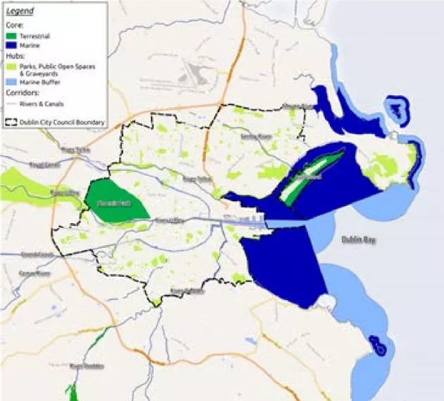
The promotion of a Green Infrastructure network in Dublin City is an action of the National Biodiversity Action Plan, the Regional Planning Guidelines and the Dublin City Development Plan (2017-2022). Dublin City’s green infrastructure network is influenced by its historical landscape prior to urbanisation, its situation on Dublin Bay and the impact of over a million people each day using its resources. The Dublin City Green Infrastructure network is comprised of:
- Core areas of designated habitats and species of national and European importance:
- Dublin Bay (and its associated terrestrial, estuarine and marine ecosystems) including all Natura 2000 sites
- The Phoenix Park, a flagship park which lies adjacent to the River Liffey.
- Dublin City Council lands at Bohernabreena and Glenasmole Valley SAC.
Action
- To ensure that management plans are prepared and implemented for Natura 2000 sites with reference to other relevant statutory bodies.
Hubs, consisting of public parks, cemeteries and open spaces, as well some privately-owned green spaces and brownfield sites, which provide support to the core areas. Many public parks are situated over former brownfield sites such as reclaimed lands, quarries and landfills. These include:
- Irishtown Nature Park, Ringsend Park
- Clontarf Promenade
- Fairview Park
- California Hills Park
- Pope John Paul II Park
- Cemeteries
Policy
- Biodiversity initiatives that are specific to the protected habitats and species will be developed for all public green spaces, which are hubs supporting core areas. These will be prepared with reference to the management plans for the core areas.
Corridors are the City’s rivers, inland waterways and wetlands, which contain designated species of national and European importance. All of the river corridors in the City have impacts on the receiving waters of Dublin Bay, which are designated as of European importance for birds and wetlands and also for RAMSAR wetlands. The main corridors and their key parks and open spaces include:
• River Mayne: Fr. Collins Park, River Mayne Linear Park flowing into Baldoyle National Nature Reserve and Natura 2000 sites
• River Santry/Naniken: Oscar Traynor Road playing grounds, Springdale Road, Silloge Golf Course, Stardust Memorial Park, St. Anne’s Park
• River Tolka: Tolka Valley Park, National Botanic Gardens, Griffith Park, Fairview Park, flowing into Tolka Estuary Natura 2000 site
• River Liffey: Liffey Valley SAAO and NHA upstream, flowing into South Dublin Bay Natura 2000 sites, Liffey Valley Park, Islandbridge War Memorial Gardens
• River Dodder: beginning at Glenasmole Valley Natura 2000 site and NHA, flowing into River Liffey and Dublin Bay Natura 2000 sites
• River Camac: flowing into River Liffey and Dublin Bay Natura 2000 sites
• Royal Canal NHA and Grand Canal NHA
Policy
• To ensure that corridors are maintained throughout the DCC administrative area as continuous elements of green infrastructure to afford passage for wildlife and prevent severance of habitats by ‘grey’ infrastructure. To work to restore connectivity of corridors where insensitive development has taken place previously or where there are opportunities to work cooperatively with landowners to promote this.