Maps of the Terenure and Crumlin Estates 1879
Published on 24th August 2016
 A collection of eight Ordnance Survey maps, donated to Dublin City Library and Archive, constitute a wonderful addition to local and family history for the Terenure Crumlin area in the late 19th century. The maps are folded and bound into one volume, bound in half leather with gilt lettering on the top cover: Maps of the Terenure & Crumlin Estates, Co. Dublin, the property of Sir Robert Shaw, Bart. 1879.
The volume belonged to the estate of Sir Robert Shaw, Baronet, and the maps cover his property in the area: Crumlin, Roundtown (Terenure), Tonguefield, Rathfarnham, Rathgar, Roebuck, Kimmage, Wilkinstown (Walkinstown), Greenhills, Whitehall and Limekiln Farm.

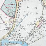
The base maps are the Ordnance Survey 1:2500 maps (25 inch) of 1866. This scale of map shows every field, every house and plot, it lists house and cottage names, shows physical and man-made features and gives an indication of land use, showing trees and gardens. The Shaw maps are hand coloured, showing the extent of the estate, and tenants’ and lessees names are written in copper-plate handwriting in each holding. The date on the cover is 1879, so this situates the occupancy of houses and lands on the estate at this period.
The estate of the Shaw family began in the late 18th-century when Robert Shaw senior purchased Terenure House in 1785. The estate was extended in 1796 when Robert Shaw junior married Maria Wilkinson, daughter of Abraham, and received as part of her generous dowry, the estate of Bushy Park. When Robert junior succeeded to the estate he made Bushy Park House his family seat, which it remained until the 1950s when it was sold to Dublin Corporation
This list of late 19th-century residents of the Shaw estate is a valuable addition to family history. It is noticeable that many tenants occupied several different plots, while others had a dwelling and a garden or some land. Schools, churches, antiquities, quarries, commercial and industrial buildings are shown. The maps provide a vivid snapshot of this area at a particular time in history.
List of tenants named on maps (PDF, 260KB)
More information on Dublin City Library & Archive's map collections.
Further Resources
Dublin City Libraries has a wide range of sources on the social, political, and cultural history of Dublin, some of which are available online and some through the Dublin City Libraries network.
The Reading Room, Dublin City Library and Archive, Pearse Street holds a wealth of material on the history of Dublin, including books, pamphlets, journals, street directories, and almanacs.
The following online resources can be accessed free of charge at your local library. Ask library staff for information and assistance.
- DRI - Digital Repository of Ireland is a national digital repository for Ireland’s humanities, social sciences, and cultural heritage data. Here you will find select digital collections of Dublin City Library and Archive. Our digital repository features photographs, postcards, letters, maps and more. Traffic jams during the 1974 CIE Bus Strikes, and jubilant Heffo’s army supporters are among 43,000 historic photographs and documents that are freely available online. Highlights of the collection include the Fáilte Ireland Photographic Collection, the Jacobs Biscuit Factory Photographic Archive, and the Royal Dublin Fusiliers Association Archive.
- Irish Times Digital Archive: This online archive service gives access to contemporary editions of the Irish Times from the mid-nineteenth century until the present.
- Irish Newspaper Archive: This online archive service gives access to contemporary editions of the Irish Independent and a range of other newspapers.
- The Ireland-JSTOR Collection: This online archive of academic articles can also be accessed free of charge at your local library.
For further reading, consult the Library Catalogue.