4.1.7 Access to Parks
4.1.7 Access to Parks
An assessment of accessibility seeks to indicate the areas serviced by city parks and those that are not. This analysis will determine deficit areas where policies can be focused.
Accessibility standards are based upon reasonable walking distances from residents’ homes. It is therefore helpful to confirm, as indicated in the results of the questionnaire in Chapter 3, that the majority of people walk to their local park, as it supports the methodology.
Where possible more sustainable means of travel to parks in Dublin should be encouraged, not only for environmental reasons, but also as there is normally limited car parking available.
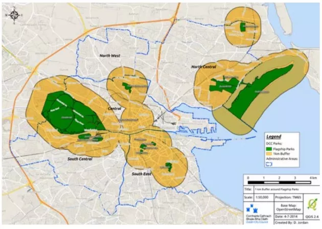
Access to Flagship Parks
The distribution and access to flagship parks is illustrated below. A 1km buffer zone, illustrated in yellow, has been provided which indicates a reasonable walking (10 – 20 minutes) or cycling distance to get to flagship parks. Access to these parks is also possible by public and private transport and it was also noted in the questionnaire returns that residents anywhere in the city will use flagship parks.
It can be seen in the plan that flagship parks are clustered in the centre of the city and along the north coastal area. Key deficit areas are prominent in the North West, North Central, South Central and to a lesser extent in the South East management areas.
To address the deficit an upgrading programme is proposed. This long-term objective will upgrade a number of existing community grade parks to flagship status (see table below).
Overall this will bring the provision of flagship parks from the current provision of 13 to 17. This will bring new flagship parks to peripheral areas and elevate the overall quality of city parks to a higher standard reflecting Dublin’s position as a
capital city and an international city. Under this strategy it is proposed to focus on upgrading two parks to flagship status.
|
Area |
Proposed Flagship Park |
Attributes |
|
Central |
Mountjoy Square |
A Georgian period park that requires historic landscape reconstruction in accordance with its conservation study proposals. |
|
North Centra |
Fairview Park |
An original tidal mud flat before reclamation and development into a park in the 1920s. |
|
North West |
Albert College Park |
The park originally was the home of an agricultural and horticultural college and named after Prince Albert in the 1850s. |
|
South East |
Fitzwilliam Square Park |
A Georgian period park that is in private ownership. Requires a conservation and historical landscape study, followed by |
Access to Community Parks
Access to community parks is assessed for each of the five management areas of the city administrative area.
A 500m buffer zone, illustrated in green on plans is used to indicate the areas that are well serviced by the parks and equates to a 5 – 10 minute walking distance. A review of areas showing reduced service (indicated in red) by management area is also given.
Overall and presently, there is limited scope to introduce new public parks into these deficit areas. Opportunities to create new open space could however occur as a result of new residential development where provision of public open space is required.
Furthermore, it is noted that some areas benefit from access to local institutional lands such as schools and colleges. In deficit areas, quality public realm and improved linkages to open space can help service deficit.
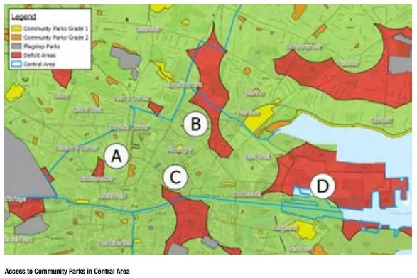
Central Area
The mapping of the Central Area indicates adequate access to local parks overall, however it is noted that the unit size of parks decreases towards the city centre. Therefore residents and visitors have good access, but it is to smaller parks compared to suburban areas.
Small pockets of the Central Area not within the 500m serviced zone are as shown in the following table.
Area of Reduced Service
|
A |
Stoneybatter |
This is a largely mixed use area, dominated by institutional uses and the new Dublin Institute of Technology campus at Grangegorman. There are no new parks proposed for this area, however residents will be able to avail of passive recreation within the grounds of this new campus |
|
B |
Drumcondra – Clonliffe Rd |
This area mainly serves residential and some mixed uses. There are no new parks planned for this area. However, possible future development of institutional lands may create further public open space in this area. Residents have the benefit of the Royal |
|
C |
City Centre |
This area includes O’Connell Street and Trinity College which is serviced by the Flagship Parks of St Stephens Green and Merrion Square |
|
D |
Dublin Port |
This area includes predominantly port related facilities and there are no parks proposed. Public realm proposals under the Docklands SDZ Planning Scheme relate to the western part of this area |
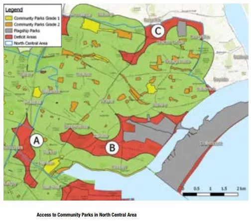
North Central Area
The North Central Area indicates adequate access overall with a mix ofpark sizes. However, there are 3 key areas that have reduced service:
Area of reduced service
|
A |
Drumcondra - Grace Park Road |
This area is dominated by institutional lands including sports grounds. It merges with Clonliffe Rd in the aforementioned deficit area in the Central Area. There is a proposed new park within the grounds of St Josephs, which will help service this area on completion |
|
B |
Donnycarney |
This is a largely mixed use area, with a number of private sports facilities, such as Clontarf Rugby and Golf Club. The grounds of the Casino under the management of the Office of Public Works is also within this area, which provides adequate open space. St Anne’s Park (Flagship) also services this area. There are no new parks proposed for this area |
|
C |
Belmayne |
This area is characterised by new housing estates surrounded by undeveloped lands. There are also some retail and industrial uses. The undeveloped land is zoned for residential uses. A Community Grade 1 park will be provided as part of new residential development and further open space will be provided along |
South East Area
The South East Management Area has reasonable access overall to community parks, however they are of smaller unit size. There are a number of privately owned open spaces, including Fitzwilliam Square, Mount Pleasant Square as well as a number of private sports grounds.
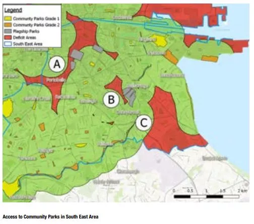
Area of reduced service
|
A |
Portobello/Rathmines Area |
This is a largely residential and mixed use area with a military barracks in Rathmines. The Grand Canal intersects this area and provides opportunities for passive and active recreation. There are no identified opportunities for new park provision. The area is also served by the flagship parks of St. Stephens Green and the Iveagh Gardens |
|
B |
Ballsbridge (Centering on Wellington Road Area) |
This is a well established residential area. There are no identified opportunities for new park provision, and the area is serviced by Herbert Park, which is a Flagship park. |
|
C |
Sandymount/ Donnybrook/ Mt.Merrion/Belfield Area |
This is a well established residential area with some institutional uses. There are no identified opportunities for provision of new parks. There are several private sports facilities, such as Elm Park Golf Club, Old Belvedere Rugby Club and Wanderers Football Club |
South Central Area
The South Central Area has good overall access to community grade parks. However, similar to other areas, there is a smaller unit size of park towards the city centre in comparison to outlying suburban areas. Key deficit areas in the South Central are Bluebell and Portobello.
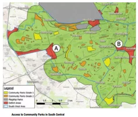
Area of reduced service
|
A |
Bluebell |
This area is dominated by several large industrial estates on the southern and western perimeters, with some residential use. The Grand Canal, immediately north provides opportunities for passive and active recreation. There is no identified requirement for new park provision |
|
B |
Portobello |
This area is dominated by residential and institutional (Griffith College) uses. The Grand Canal immediately south, provides linear recreational space for active and passive recreation. There are no identified opportunities for new park provision. |
North West
In the North West Area, there is overall good access to community grade parks. Notable to this area is the cluster of contemporary designed Grade 1 parks developed as part of the Ballymun regeneration scheme.
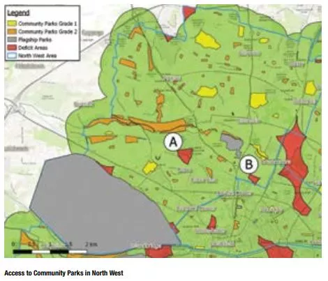
Area of reduced service
|
A |
Cabra West – Bannow Rd |
This area primarily contains residential and industrial uses. There are no new parks proposed for this area. However, residents have the benefit of the Royal Canal being immediately adjacent. Improvements to the canal open space corridor are desirable |
|
B |
Drumcondra – Whitworth Rd |
This area mainly serves residential and some mixed uses. There are no new parks planned for this area. However, residents have the benefit of the Royal Canal being immediately south of this area for both passive and active recreation |
Policy
- To maintain a hierarchy of parks within reasonable access of the residents of Dublin.
Actions
- To improve access to Flagship Parks by the upgrading of community parks to flagship status as follows:
- Central Area: Mountjoy Square Park
- North West Area: Albert College Park
- To seek public access to Fitzwilliam Square Park