5.1 The Coast
5.1 The Coast
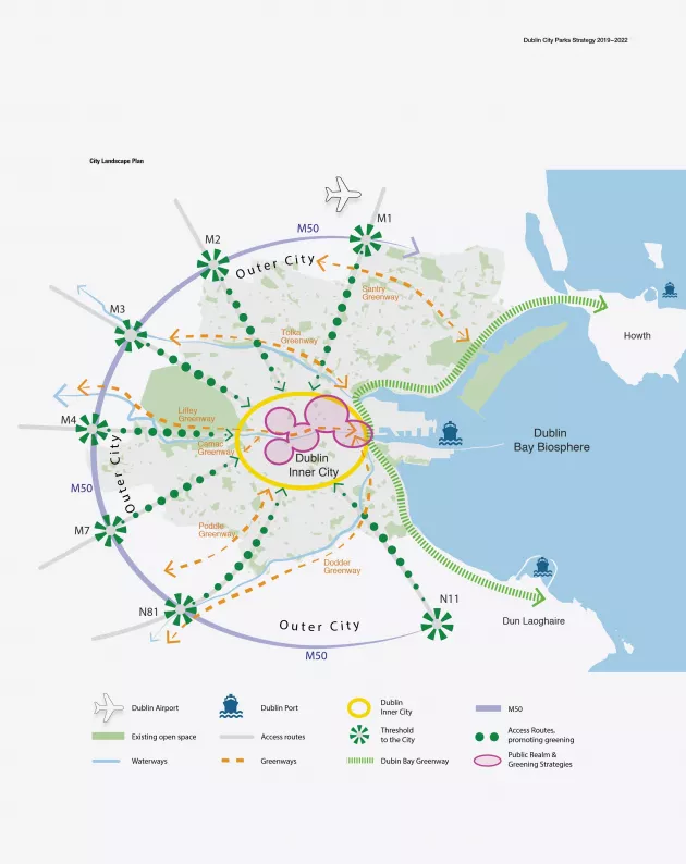
The coast, where the city meets the sea, is a complex linear zone with varying levels of access, connectivity and activity. It is a product of the organic development of the city spreading north and south along the bay. The city coastal landscape is an area that deserves greater attention to its planning and design. How many of those who visit or work in Dublin every day actually experience the sea?
The existing spatial characteristics along the coast vary, from highly accessible linear parks at Clontarf and Sandycove to less defined connections at the Docklands where the Liffey severs connectivity. Nodes of activity along the coast include beaches, promenades, quays, sea walls and parks and the coastal nodes of Howth and Dun Laoghaire harbours.
The city landscape plan conceptually envisages a continuous green coastal corridor, a Dublin Bay Greenway, accessible from Howth to Dún Laoghaire, providing green transport, recreational use and biodiversity areas.
This corridor provides for bicycle and pedestrian routes as well as serving recreational needs for local areas along the route, connecting north and south and back into the city centre and suburbs along the way with a coordinated use of materials, way finding and interpretation. To develop this further, a Dublin Coast Landscape Plan is envisaged that would be a coordinated project between the Local Authorities and relevant management agencies, such as Dublin Port.
Policy
- Park Services will promote a Dublin Bay Greenway (former S2S), a continuous green coastal corridor along Dublin Bay.
Actions
- To assist in the preparation of a Dublin Coast Landscape Plan with other partners to enhance recreation, greening, biodiversity and green transportation.