The Dodder Greenway: Beatty’s Avenue to Herbert Park
This section of the Dodder Greenway provides 0.5km of walking and cycling facilities between Beatty’s Avenue and Herbert Park. This scheme is now complete.
This section of the Dodder Greenway links Herbert Park to Beatty’s Avenue through Anglesea Road and Merrion Road. The Beatty’s Avenue to Herbert Park Scheme is a key part of the Dodder Greenway and provides improved pedestrian and cycle facilities along the route.
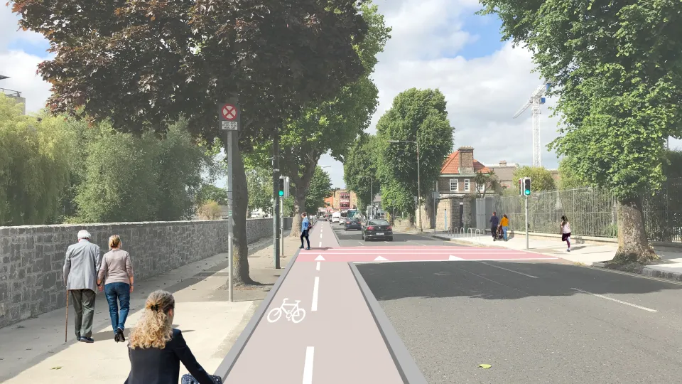
A "quiet street", which mixes cyclists and vehicles, has been provided along Beatty’s Avenue by way of road markings. Cyclists share the existing carriageway with traffic along this low traffic volume street.
Shared areas for pedestrians and cyclists have been delivered on both sides of the Merrion Road at the new pedestrian and cyclist crossing, located to the west of the junction with Anglesea Road. The existing pedestrian crossing on Anglesea Road has been upgraded to become a pedestrian and cyclist crossing.
Construction on this scheme started in early 2025 and was officially opened with a launch ceremony on the 12th of September 2025. The contractor for the works was Circet Networks (Ireland) Limited.


Learn More About This Section

Key Changes
- Beatty’s Avenue is now a shared area for both motorists and cyclists. However, the riverside walkway on Beatty’s Avenue has remained unchanged.
- A new crossing facilitates pedestrian and cyclist movements north/south on Merrion Road.
- Two parking bays on Merrion Road have been removed to facilitate the new crossing.
- An accessible parking bay on the north side of Merrion Road has been relocated east by 11 metres.
- A two-way protected cycle lane along the riverside of Anglesea Road separates cyclists from traffic by way of segregation kerbs.The existing path remains unchanged.
- One of the two existing left turn lanes from Anglesea Road to Merrion Road has been removed to facilitate the two-way cycle lane.
- Eight existing parking spaces on the riverside of Anglesea Road, opposite Pembroke Library, have been removed. Additional parking has been provided on the opposite side of Anglesea Road.
- The accessible parking bay on the east side of Anglesea road, near Pembroke library, has been retained.
- The existing pedestrian crossing on Anglesea Road has been converted to a pedestrian and cyclist crossing.
- A raised crossing has been provided at the bridge entrance to the Pines Apartments on Herbert Park Lane.
- All existing boundaries and trees along the route have been retained.
This scheme has been delivered to:
- Provide quality, protected cycling facilities to cater for all ages and abilities along the Dodder River
- Facilitate a more active lifestyle for all ages bringing multiple benefits for physical and mental wellbeing
- Provide improved pedestrian and cycle facilities across the Merrion Road
- Contribute to a reduction in transport emissions in line with the objectives of the Climate Action Plan by encouraging a shift to Active Travel use
This scheme provides an Active Travel link along the Dodder River as part of the overall Dodder Greenway scheme and into future walking and cycling and public transport schemes.
The overall aim is to improve walking and cycling facilities for local communities and facilitate the shift towards more sustainable modes of transport for both commuting and leisure.
A non-statutory public consultation process was carried out for the scheme and drawings were available to view from 29 May 2023 to 30 June 2023.
An information event was also held on 15 June 2023 at Sandymount Community Centre, Newbridge Avenue, Sandymount. It was well attended and gave the public the opportunity to discuss the proposals with Dublin City Council.
The National Transport Authority is funding this scheme.
Yes. Traffic impacts along the route have been considered as part of the environmental screening exercise.
In order to deliver this scheme, there has been some minor temporary disruption to traffic in the area. Dublin City Council, in collaboration with our contractor, has endeavoured to minimise this as much as possible.
Yes. The following screening assessments have been completed:
- Environmental Impact Assessment Screening.
- Appropriate Assessment Screening.
Both screening reports concluded that neither an Environmental Impact Assessment report nor an Appropriate Assessment Report were required for this phase of the scheme.
No. All works proposed remained outside of the river and its banks. Existing footpaths and road space was used for the new infrastructure.
On Beattys Avenue
Parking has been unaffected along Beatty’s Avenue between Herbert Cottages and Merrion Road.
On Merrion Road
Two of the existing pay and display/permit parking spaces (07.00-19.00, Monday to Saturday) on the north side of the Merrion Road have been removed. No parking permits were issued for this stretch of Merrion Road.
The existing accessible parking bay has been relocated eastwards by approximately 12 metres.
On Anglesea Road
Eight pay and display/permit parking spaces (10.00-19.00, Monday to Saturday) have been removed on the west side of Anglesea Road between Merrion Road and Herbert Park Bridge. These parking spaces were within a 07.00-10.00 Monday to Saturday clearway.
Following the removal of these spaces, there are 37 more spaces available on Anglesea Road than parking permits issued. The spaces removed were 180 metres from the nearest Anglesea Road house.
The existing accessible parking bay on the east side of Anglesea Road outside Pembroke Library has been retained.
This scheme has been designed with planned or committed projects in mind to ensure there are no conflicts between proposals. Notable adjacent projects include the River Dodder Flood Alleviation Scheme and BusConnects Dublin.