2.2.2 Housing Strategy
2.2.2 Housing Strategy
(See Appendix 2)
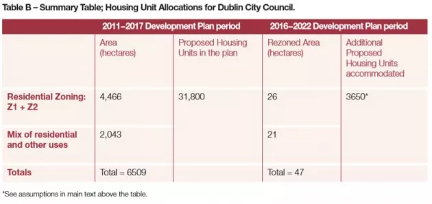
The following table identifies the extent of residential zoned lands and also mixeduse zonings which include residential uses. Zoned areas in the 2011 – 2017 plan are set out alongside newly proposed re-zonings. These re-zoned lands comprise a total of 47 hectares, with the emphasis on housing, often in a mixed-use zoning. Based on a density assumption of 100 units per hectare and also assuming that 50% of the mixeduse component would be in residential use, this 47 hectares has the potential to provide for an extra 3,650 units.
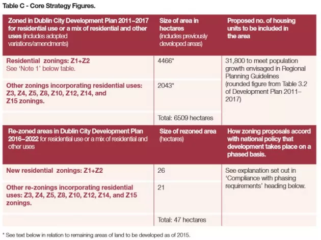
The content of the above table is further expanded on below in accordance with Section 10 (2A) of the Planning and Development Act 2000 (as amended).
Whilst the table above contains the information required for the core strategy under the Planning Acts, it must be interpreted in the Dublin City context, whereby all of the land is already zoned for different uses. The vast majority of the 4466 hectares of existing Z1 and Z2 zonings (residential and residential conservation areas respectively) are already built out. However, for purposes of this plan, it is estimated that there are circa 210 hectares remaining to be developed in these zones, with the potential to provide for 34,000 residential units (based on the housing land availability study).
Similarly, the other zones which can accommodate residential (and other) uses are also largely built out, yet it is estimated that 230 hectares of the 2043 hectares (from Table C) remain to be developed, which will give a yield of circa 18,000 units (excluding windfall sites and vacant lands of which 61 hectares of the latter have been identified in the inner city).
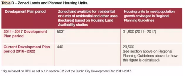
When the additional figure of 3650 units (i.e. additional proposed housing units) is incorporated into the adjusted zonings, the units that can be accommodated total in excess of 55,000 units (i.e. 34,000 + 18,000 + 3650) on the remaining 440 hectares.
Hence, it is concluded that there is sufficient zoned land to provide for the development plan period.
Compliance with Phasing Requirements
Dublin city is designated as a gateway core in the RPGs. All of Dublin City Council’s functional area is located within the metropolitan area, which the guidelines seek to consolidate to achieve a more compact urban form allowing for the accommodation of a larger population.
The city is largely built out, with the builtup area and suburbs extending into the surrounding counties of Fingal, South Dublin, and Dún Laoghaire–Rathdown. The available remaining lands within the city are serviced and fully zoned. In this context, local area plans, strategic development zones, and some zonings which require the preparation of masterplans may establish more detailed phasing or prioritisation for the delivery of residential uses, other uses, or infrastructure, as appropriate. Such locally-based plans, and related requirements, are set out in this chapter under the heading ‘Delivering the Core Strategy’ (section 2.2.8), and also in Chapter 14 (Regarding Zoning-related Requirements), and Chapter 15 (Strategic Development and Regeneration Areas).