15.1.1.1 SDRA1 North Fringe (Clongriffin–Belmayne)
15.1.1.1 SDRA1 North Fringe (Clongriffin–Belmayne)
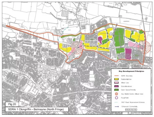
The north fringe action area plan was first produced for the North Fringe lands in 2000, setting out the objective to extend the metropolitan core and create a new dynamic mixed-use urban quarter. With a strong urban design framework in place,
much has already been achieved including the development of over 3,400 new homes and 41,000 sq m of commercial floor place. In addition, key water and drainage infrastructure, a new railway station and public square, sections of the new main street boulevard and the much-acclaimed Father Collins Park are all in place.
While the original plan was intended to be a long-term plan for the area, the slowdown in the construction sector from 2008 meant that many key sites remain undeveloped. A statutory local area plan was subsequently produced for the area and adopted by the City Council in December 2012. It sets out a detailed framework and phasing mechanism for the development of the remaining key sites, with the aim of providing approximately 8,000 new homes upon completion.
The local area plan is based on the following key objectives/guiding principles:
1. To create a highly sustainable, mixed use urban district, based around high quality public transport nodes, with a strong sense of place.
2. To achieve a sufficient density of development to sustain efficient public transport networks and a viable mix of uses and community facilities.
3. To establish a coherent urban structure, based on urban design principles, as a focus for a new community and its integration with the established community, comprising the following elements:
- A central spine route, in the form of a boulevard or high street, linking the Malahide Road with the proposed train station to the east
- Two high quality urban squares (one at the junction of the Malahide Road with the Main Street boulevard and the other adjacent to the rail station) as the main focus for commercial and community activity
- A series of smaller urban squares as significant place markers and activity nodes, e.g. a recreation square adjacent to Father Collins Park
- A flagship urban park in the redesigned Father Collins Park
- A new perimeter route running north from the Malahide Road via Belcamp Lane, relieving traffic pressure from the N32 and from the proposed Main Street boulevard
- An interconnected network of streets and public spaces
- To promote the creation of a high-quality public domain by establishing a high standard of design in architecture and landscape architecture
- To use building heights to define key landmark locations, including:
- Minimum heights of 5 storeys for the key district centres at Clongriffin rail station and the N32/Malahide Road junction
- Minimum heights of four to five storeys for the Main Street boulevard
- A landmark structure of 10-14 storeys (office height) adjacent to the rail station.
- To develop the amenity potential of the Mayne River in the creation of a linear park To develop an urban design strategy for the lands at St Michael’s Cottages that is co-ordinated with the overall strategies for the developing areas