15.1.1.10 SDRA 7 Heuston and Environs
15.1.1.10 SDRA 7 Heuston and Environs
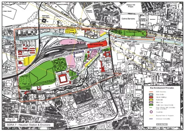
An urban design land-use framework plan for the regeneration of the Heuston area was produced in 2003. This plan provided a regeneration framework for key development sites addressing issues of spatial layout, urban grain, massing, height and land-use and the need to interface such sites successfully with the Phoenix Park, the River Liffey and cultural institutions. The vision for the area as set out in this study is: ‘to create a coherent and vibrant quarter of the city that captures the public imagination with high quality services, development, design and public spaces that consolidate and improve the existing strengths of the area.’
Since the publication of the 2003 report, this area has undergone significant redevelopment, including much of the Heuston South Quarter and development at Clancy Barracks. A number of significant land banks still remain to be developed and for these the following guiding principles shall apply:
1. To develop a new urban gateway character area focused on the transport node of Heuston Station with world class public transport interchange facilities, vibrant economic activities, a high-quality destination to live, work and socialise in, a public realm and architectural designs of exceptional high standard and a gateway to major historic, cultural and recreational attractions of Dublin City.
2. To incorporate sustainable densities in a quality contemporary architecture and urban form which forges dynamic relationships with the national cultural institutions in the Heuston environs.
3. To ensure the application of best practice urban design principles to achieve:
- A coherent and legible urban structure within major development sites
- A prioritisation on the provision of public space
- A successful interconnection between the development site and the adjacent urban structure
4. To protect the fabric and setting of the numerous protected structures and national monuments, many of which are major national cultural institutions.
5. To incorporate mixed-use in appropriate ratios in order to generate urban intensity and animation. This will require the major uses of residential and office to be complemented by components of culture, retail and service elements.
6. To improve pedestrian and cycle linkages throughout the area and through key sites, with a particular focus on seeking the following new linkages/improvements: along St John’s Road West; from St John’s Road to the Royal Hospital Kilmainham via Heuston South Quarter, subject to agreement with the OPW/RHK, on the nature of the proposed linkage; from Dr Steevens’ Hospital to IMMA, with consideration give to a new path along the banks of the river Camac.
7. As a western counterpoint to the Docklands, the Heuston gateway potentially merits buildings above 50 m (16-storeys) in height in terms of civic hierarchy. Sites particularly suited for tall buildings include:
- OPW building: corner site on OPW lands adjacent to Dr Stevens’ Hospital and Park, and opposite the south façade of the station building.
- CIE building: site to the north of the station building on the river relating to the West Terrace and River Terrace. Any new mid or high-rise buildings must provide a coherent skyline and not disrupt key vistas and views.
8. The ‘cone of vision’, as set out in the 2003 Heuston Framework Plan, represents a significant view between, the Royal Hospital Kilmainham and the Phoenix Park extending from the west corner of the north range of the Royal Hospital Kilmainham, and the north-east corner of the Deputy Master’s House to the western side of the Magazine Fort and east edge of the main elevation of the Irish Army Headquarters (former Royal Military Infirmary) respectively. Any new developments within this ‘cone’ shall not adversely affect this view. A visual impact analysis shall be submitted with planning applications to demonstrate this view is not undermined.
9. Other important visual connections to be respected include Chesterfield Avenue to Guinness Lands and from key parts of the City Quays to the Phoenix Park (Wellington Monument).