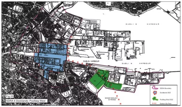
15.1.1.9 Poolbeg West
15.1.1.9 Poolbeg West
This site presents an opportunity for the city to deliver significant levels of private and public housing, employment, schools, community and recreational facilities within the life of the development plan. A masterplan will be required to demonstrate how the SDRA principles will be delivered on a phased basis. The following guiding principles apply:
Social and Economic
- To deliver a socially inclusive and economically vibrant mixed-use urban precinct, with housing and employment uses set within high quality neighbourhoods and working environments (see also Appendix 2A: Housing Strategy and Chapter 5 – Quality Housing)
- To provide for a range of dwelling types and tenure options that will promote social integration and cohesion, supported by facilities that meet the needs of the resident and working population in a sustainable and self sufficient manner
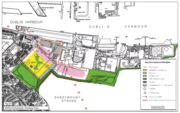
- Provide employment-generating uses, primarily focused on South Bank Road.
Use and Urban Form
- The area will support primarily residential and employment-generating uses with
- commercial uses focused in the vicinity of South Bank Road
- Lands to the north of South Bank Road may be used for port-related activity subject to an adequate buffer zone of good quality architecture fronting onto South Bank Road
- Lands to the south of South Bank Road shall be developed at an approximate ratio of 70% residential and 30% commercial, complemented by community, recreational, retail and service uses at an appropriate scale to support a sustainable and self-sufficient resident and working community Public bus, bike and routes through the site will act as primary organising routes for the overall structure of the development; public open spaces and active uses will hinge from these principal connections adding vibrancy and activity
- Connections are to be created and improved between existing public parks, recreational and amenity assets in the area including the south bay and shore line, Sean Moore Park, Sandymount promenade and strand, that will optimise their amenity value
- A high-quality coastal public promenade at an appropriate scale will link Irishtown Nature Park with Beach Road
- An internal network of green spaces will create a series of landscaped open spaces, bike and pedestrian access which, in turn, will reinforce and enhance the creation of a distinct urban form and sense of place; buildings on the site will frame a pattern of courtyards, open spaces and pedestrian-friendly streets, creating distinct forms with strong individual identities
- Two nodal spaces will provide major activity areas for the community, including a social and education node to the south adjoining Sean Moore Park, and a commercial and cultural core node to the north centred on a new public square or plaza which will create a social focus for employment, cultural and active uses
- Opportunities to connect with the surrounding street network will be maximised to link the development into the urban fabric; main entrances offer ‘gateways’ to the community from the surrounding roads and the design of these thresholds will offer opportunities for landmark features and creating welcoming spaces
- The development will be predominantly under 28 m in height (4-7 storeys commercial and up to 9 storeys residential), to promote appropriate setting, amenity and integration with the surrounding urban fabric; mid-rise heights of up to a max of 50 m at a limited number of locations in the vicinity of South Bank Road will create variances in place-making, urban form and street character Development should take account of views towards the bay and to the Dublin Mountains
- A phased approach to the overall development will be sought, with key public infrastructure to be ‘front loaded’, including early provision of public transport infrastructure, two new primary schools and new recreational spaces/ public realm enhancements. In order to promote sustainable transport modes, a Traffic Impact Assessment (TIA) shall be prepared setting out the threshold for development allowable before the Dodder public transport bridge is constructed.
Movement and Sustainability
- Emphasis will be on sustainable modes of transport, particularly through the expansion of walking and cycling routes and improved connections for pedestrians, cyclists, and public transportation modes including bus; streets will be designed with wide footpaths and cycle paths to prioritise ‘green routes’
- The early phases of development will facilitate public transport, pedestrian and cycling links from the city and Docklands, through the site, to Sandymount and beyond; the Sutton to Sandycove cycling route, which forms part of the East Coast Trail, will be accommodated through the site
- To promote the use of sustainable modes of transport, car parking provision will be below the development plan maximum standard and bicycle parking facilities will be in excess of the development plan standards
- New buildings will incorporate sustainable and renewable energy sources and building techniques, including utilisation of district heating.
Environment
- Development will be compatible with and protect the nature conservation designations of the south bay, including the habitats directive
- The unique landscape qualities of the Poolbeg peninsula, rivers and bay area will be protected and enhanced, and the existing open character and nature of the coastal views from Irishtown Nature Park will be retained.