15.1.1.19 SDRA 16 Liberties and Newmarket Square
15.1.1.19 SDRA 16 Liberties and Newmarket Square
The Liberties statutory local area plan was adopted by the City Council in May 2009 and in April 2014 the timescale of the plan was extended until May 2020. The main purpose of the Liberties local area plan is to ensure that in developing individual land parcels, opportunities for regenerating the area in an integrated fashion are not missed. The 2009 plan provided a comprehensive, area-wide assessment of housing, open space, community facilities, employment opportunities etc., setting out key objectives for each theme.
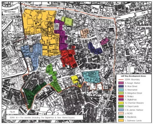
Opportunities for new development were focused on key re-development sites (see map). While some progress has been made in delivering on these objectives, it is clear that the economic downturn has significantly impacted upon the overall delivery of the objectives of the LAP. While it is acknowledged that some of these objectives, including the re-development of the Council’s housing stock, will not be achieved within the life of the plan, there remains many other sites where development is to be encouraged and promoted within the context of the LAP.
The proposed location of the National Children’s Hospital to the adjoining St James’s Hospital, the consolidation of Diageo/Guinness on their lands to the north of James’s Street/ Thomas Street, and the proposed investment in the public realm/‘Greening Strategy’ by Dublin City Council, all have the potential to lift the area and stimulate re-development. Retaining the LAP objectives of open spaces, linkages, conservation, usage, public realm etc. are important to ensure that new development enhances the holistic physical, social, economic and environmental regeneration of this key part of the city.
It is noted that part of the lands zoned Z10 around Newmarket Square, south of Mill Street, are not included within the LAP boundary. It is considered that the guiding principles of the LAP shall extend to include this area.
Overall guiding principles/objectives of the LAP:
1. To improve the quality of life so that the Liberties area becomes a great place for people to live, work and visit.
2. To provide for appropriate social and community infrastructure to support the existing population, which is growing and becoming increasingly diverse.
3. To provide for a wide diversity and choice of housing that can cater for families and older people by including options for mixed tenure and a range of housing types and unit sizes.
4. To stimulate the local economy and to include a critical mass of appropriate development and investment to provide significant employment opportunities, including in the digital media sector, as the Digital Hub has the potential to rejuvenate the economic profile of the Liberties.
5. To recognise the unique role the Liberties plays in Dublin’s character and to ensure that regeneration safeguards a strong sense of community identity.
6. To identify and protect the distinctive heritage of the area and encourage sustainable and innovative re-use of historic spaces and structures.
7. To ensure that the individual character of different areas within the Liberties is protected and enhanced by contemporary and high-quality design of new buildings.
8. To promote the principles of good urban design including improving connectivity and enhancing the legibility and permeability of the Liberties in relation to the wider cityscape.
9. To create a high-quality network of public spaces, parks and streets.
10. To promote sustainable modes of transport by making them convenient and attractive, including walking and cycling routes, and by facilitating the provision of public transport infrastructure and optimising its use.
11. To improve and encourage the cultural and tourist offer of the area.
12. To encourage environmental sustainability by improving biodiversity, facilitating recycling, and minimising the use of non-renewable resources, including energy.
Height Strategy:
With regard to the Digital Hub Area:
- One or more carefully placed mid-rise buildings on the two Digital Hub sites (Crane Street and Windmill) would respond to the industrial legacy of taller buildings as part of the Guinness complex and as symbols of the new digital economy. Such buildings must be located to provide a coherent profile along the Thomas Street/James’s Street Ridge, when viewed from the historic city, including from the quays, the environs of the St Catherine’s Church and St John’s Church.
With regard to the Grand Canal Harbour and Basin Area:
- To provide for a cluster of height including mid-rise and taller buildings. Locations must be selected to protect the setting of protected structures. The grouping and profile of the cluster must be managed to avoid clutter on the skyline.