15.1.1.14 SDRA 11 Stoneybatter, Manor Street and O’Devaney Gardens
15.1.1.14 SDRA 11 Stoneybatter, Manor Street and O’Devaney Gardens
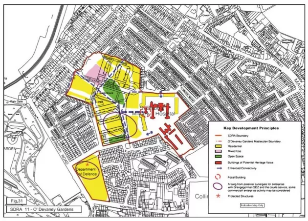
The O’Devaney Gardens public housing complex was constructed in 1954 by Dublin City Council and originally consisted of a total of 278 residential units contained in 13 four-storey blocks. Today, just four of the blocks remain on the site with the remainder cleared for re-development. To the south-west of the site, along Infirmary Road, is another significant land bank once owned by the Department of Defence, now under the control of Dublin City Council and available for re-development. Together these sites have an area of c. 10 hectares and form a Strategic Development and Regeneration Area (SDRA11) within the City.
In order to progress the development of this key site, Dublin City Council prioritises the compilation, development and implementation of a statutory based local area plan for the Stoneybatter district. The boundary upon which the statutory based local area plan will apply is the North Circular Road to the north, Infirmary Road to the west, Montpelier Hill to the south and the boundary of the Grangegorman SDZ to the east.
The key guiding principles for developing this strategic development and regeneration site include: The strategic location context of this site within the city (close to the amenities of the Phoenix Park, Heuston Station and the new Criminal Courts of Justice), its potential positive contribution to the character of the city and the potential that exists for greater synergies to Stoneybatter and Grangegorman will be valued and promoted; there is an opportunity for a mid-rise residential building towards the centre of the site, similar to that within the Grangegorman SDZ.
The development of a high-quality residential quarter comprising quality new homes supported by a complementary range of mixed commercial, community and recreational facilities will be promoted for this site. The site will provide for a mix of tenure with social, affordable and private housing all provided on site.
The development of attractive new streetscapes with mixed typologies of high-quality accommodation, a high-quality public realm and active street frontages will be promoted to complement the architectural legacy of streetscapes adjoining this location, including the special streetscapes of the North Circular Road, Infirmary Road and Oxmantown areas.
Accessible locations for commercial and community facilities to encourage interaction between the site and established communities adjoining will be promoted.
The development of a neighbourhood park as a key feature of the design to provide recreational amenities, encourage community interaction and provide a focal point/meeting place for the wider local community; the location will be bounded by high quality streetscapes accommodating commercial, community and residential uses to generate activity, encourage active use of the space and provide passive surveillance. To provide space for an all-weather pitch, multiple use games area (MUGA), community centre, and community garden. Provide quality open green spaces consisting of a minimum of 15% of the site area. Green spaces can serve as sites of social exchange and communicate a respect for nature as a guiding design principle for the site.
The established character of streets and residential amenities for adjoining residents will be respected in the urban design proposals and layout of a new development; opportunities for new building forms to aid legibility through the scheme and create streetscapes of visual interest will incorporate appropriate height transitions from site boundaries and propose locations that avoid negative impact on adjoining residential boundaries.
Permeability through the site will be promoted to integrate the location more successfully with the adjoining community; the existing bus route will be retained and incorporated along a main boulevard route connecting the North Circular Road to Montpelier Gardens; opportunities for connections with streets to the north-east boundary, with particular emphasis on walking and cycling routes, will be encouraged.
To have regard to the physical integration and regeneration potential of Manor Street/Stoneybatter as important streets/radial routes in the redevelopment proposals for this area.