13.11 - SDRA 9 – Emmet Road
13.11 - SDRA 9 – Emmet Road
Introduction
The SDRA builds on the Kilmainham-Inchicore Development Strategy and identifies a number of industrial/former industrial sites, Dublin City Council housing sites and other potential regeneration sites that offer strategic regeneration opportunities for the area.
Leveraging key pieces of public infrastructure such as the Grand Canal cycleway and the Luas Red Line, the SDRA seeks to provide a strategic vision for the redevelopment of these regeneration sites and to improve their connections to the villages of Inchicore and Kilmainham.
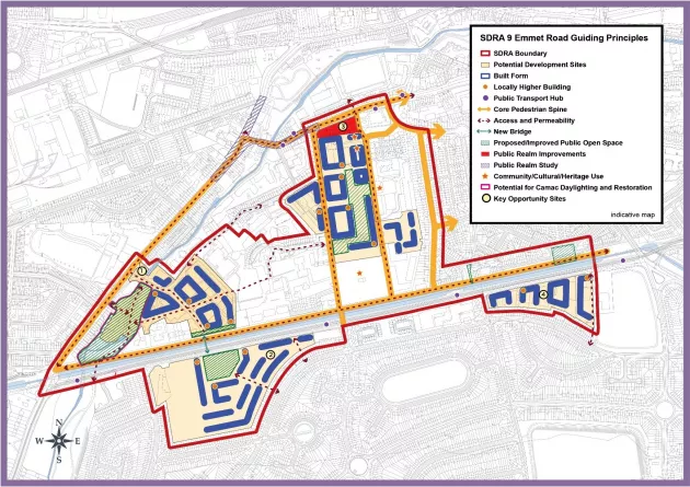
The guiding principles for the development of this SDRA as set out below:
Urban Structure
- To recognise the natural and constructed features such as rivers, canals and rail lines that have strongly influenced the urban structure of the area, as well as its morphology over the last century.
- To encourage development that reinforces the village cores of Inchicore and Kilmainham, connected by Emmet Road, as the central spine of the area.
- To seek to provide interventions that contribute a finer grain to the urban structure of the wider area, especially on former industrial and institutional lands.
- To recognise and enhance the role that cultural and historic buildings play in the identity and legibility of the wider area.
Land Use & Activity
- To encourage the transition from industrial or former industrial use to mixed-use/residential use in the four 'potential development sites' identified in the Guiding Principles Map whilst acknowledging the role many of the uses play in the local economy and community.
- To deliver a new civic and community hub as part of the redevelopment of the Emmet Road Regeneration Site.
- To facilitate the reconfiguration/consolidation of educational uses in the Emmet Crescent area.
- To capitalise on the presence of Richmond Barracks and Goldenbridge Cemetery within the Inchicore area and to facilitate the creation of linkages to other nearby historic and cultural uses.
Height
- To support heights of 6-8 storeys for new developments in the SDRA area where conservation and design considerations permit. Opportunities for locally higher buildings above this height are identified in the accompanying Guiding Principles Map.
Design
- To ensure that new buildings respond to the scale and grain of the prevailing character of the particular street.
- To undertake public realm studies for both Kilmainham and Inchicore villages.
- To create a civic plaza at the Emmet Road end of the redeveloped Emmet Road Regeneration Site.
- New apartment buildings to generally have own-door access for all dwellings at ground floor level to contribute to increased vitality and activation of the area.
Green Infrastructure
- To promote the undertaking of a Greening Strategy for the wider Kilmainham-Inchicore area.
- To support the re-naturalisation of the Camac River in association with the Camac Flood Alleviation Scheme.
- To better integrate the Grand Canal with the wider Kilmainham-Inchicore area.
- To create a linked network of greening corridors including walkways, biodiversity corridors, cycleways and parks, as identified in the Guiding Principles Map. These should be attractive, welcoming and accessible, feed into a wider network and connect up to the local schools in the area.
- To ensure that the public open space provision of development sites be sited at locations that are visible, accessible and inviting to the wider public.
Movement
- To facilitate delivery of cycle routes identified in the NTA GDA Cycle Strategy.
- To facilitate the delivery of the permeability interventions identified in the Guiding Principles Map, which seek to improve accessibility throughout the area.
- To improve connectivity north-south across the Grand Canal/Davitt Road and east-west between Goldenbridge Industrial Estate and the Emmet Road Regeneration Site.
- To encourage development that enhances the vitality of the emerging network of walking and cycling infrastructure.
- To seek the delivery of a new bridge crossing the Grand Canal through any redevelopment of Development Sites 1 and 2 as indicated in the Guiding Principles Map.
- To maximise the potential benefit of the BusConnects project to the SDRA area in terms of public realm improvements, green infrastructure and pedestrian and cycling infrastructure.
Guiding Principles for Key Opportunity Sites
1 - Goldenbridge Industrial Estate
The redevelopment of this site presents the opportunity to create east-west connections via Mercy College Secondary School and north-south with the opening up of the southern boundary of the site. Buildings should provide active and animated edges to the canal and also to the identified connections.
The Camac River is culverted for the majority of its journey through the site. The potential for its renaturalisation should be investigated further via a masterplan process in tandem with the River Camac Restoration Project. Refer to Policy SI11 and SI12 for further details.
2 - Davitt Road West
This site provides significant opportunity for residential led development. The majority of this sites allocation of public open space should be located at the Davitt Road frontage, opposite Goldenbridge Industrial Estate, where it is visible, inviting and accessible to the wider public. Locally higher buildings framing it should provide appropriate levels of enclosure without undue overshadowing.
Connections through the site should be created to link the public open space to the neighbourhood centre on Galtymore Road while connections should be made to the north via a new bridge across the Grand Canal.
Buildings running along the southern and eastern boundary should be appropriately scaled and massed to respond to their residential interface with the properties fronting onto Carrow Road and Galtymore Road.
Should the HSE site and lands immediately to the north of same on the western end of the site become available for development, it should align with the proposals set out for the rest of the site.
3 - Emmet Road Regeneration Site
This site is located at the heart of the SDRA area. It is proposed to be redeveloped as a mixed use scheme which, as well as being Dublin City Council's first cost rental residential development, will accommodate a mix of community uses, including a new community centre and library.
Commercial units, including a supermarket should be located at the northern end of the site, fronting onto a civic plaza along Emmet Road. The site's redevelopment will serve to tie together the wider SDRA area.
In relation to heights, the Emmet Road site is considered capable of delivering a new baseline height of 8 storeys with locally higher buildings in specified locations as detailed in the Guiding Principles Map, Figure 13-9, subject to detailed design and to compliance with Appendix 3 of the development plan.
In relation to unit mix and typologies and having regard to the cost rental nature of the scheme and the particular profile of housing provision in the area, the standards set out in Section 15.9.1 of the Plan are not necessarily applicable to the Emmet Road project.
Any redevelopment of Tyrone Place should seek to integrate with the wider redevelopment of the Emmet Road Regeneration Site. In particular, along its eastern boundary building heights should address the emerging heights on the opposite side of the St. Vincent St. West. Along the northern boundary, the built form should respond to the prevailing heights and grain of buildings on the opposite side of Thomas Davis St. West and contribute to the creation of a more cohesive character to the street.
4 - Davitt Road East
While this site appears to be in a number of different ownership parcels, any redevelopment of the sites should follow the pattern identified in the Guiding Principles Map, with buildings appropriately spaced. A number of locally higher buildings located along the Davitt Road edge could deliver urban design benefits. Due to the fragmented ownership, the public open space provision could be provided via a contribution in-lieu, to be used for the upgrading of nearby areas of public open space such as at Devoy Road or the unused space on the canal end of Goldenbridge Terrace.
Figure 13-12: SDRA 9 Emmet Road