13.5 - SDRA 3 – Finglas Village Environs and Jamestown Lands
13.5 - SDRA 3 – Finglas Village Environs and Jamestown Lands
Introduction
Finglas Village and Environs and Jamestown Lands have been designated as a Strategic Development and Regeneration Area (SDRA) due to the strategic location of the area, the proposed new public transport network and the extent of available lands suitable for regeneration, covering an area of 52 hectares in total. The designation of the area as a SDRA seeks:
- To support the economic revitalisation of Finglas Village.
- To provide for more varied and intense mix of uses within the Dublin metropolitan area.
- To maximise the potential of a well-connected but underutilised brownfield area located adjacent to the proposed Luas green line extension to Finglas, and proposed Finglas Core Bus Corridor.
The Jamestown lands, located to the immediate north of the village, at 43.1 hectares, are currently used for a range of low density employment and other uses, with a high level of underutilisation and a number of vacant sites. They have been identified as having significant potential for regeneration and providing new brownfield redevelopment within the city, proximate to existing services and planned high quality public transport investment.
A number of key development opportunity sites exist in the village with potential to implement urban design improvements by capitalising and building on existing assets in order to develop a distinct spatial and cultural identity for the area.
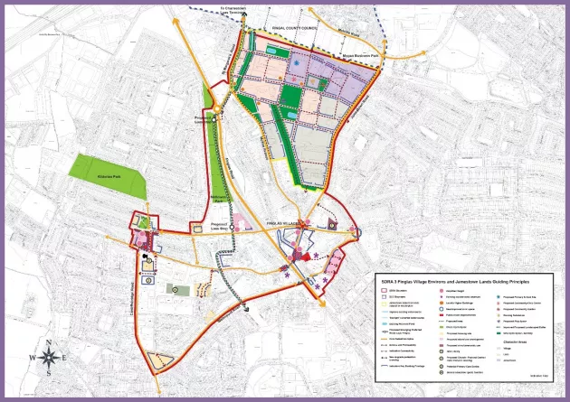
Specific guiding principles are set out for both Finglas Village Environs and the Jamestown Lands and a detailed Guiding Principles Map for the area is included in this SDRA (see Figure 13-3). Some opportunity sites may require a change of zoning to facilitate development.
A: FINGLAS VILLAGE ENVIRONS
Urban Structure
- New developments in the village and environs to create enclosure and form active frontages with the streetscape.
- The SDRA Guiding Principles Map identifies a number of development opportunity sites and illustrates indicative key building frontages that respond to the existing street and block structure. The development of a fine urban grain is necessary in order to enhance permeability. The built form to limit the use of set-backs, in order to create a strong street edge and sense of enclosure.
- The bulk, scale and massing of buildings should respect and respond to the site-specific context, including historic building stock and archaeological features.
- Key village gateways or arrival points are identified as a fundamental part of the overall urban design strategy and as a tool to re-define the village core. These gateways will reinforce the function and status of the village, enhance the townscape and improve the overall image of Finglas.
- The SDRA Guiding Principles Map identifies public realm projects and urban plazas that will enhance the legibility and townscape, and foster the creation of identity. Key spaces include: a proposed village ‘Triangle’ as the primary civic space and focal point for the village; a new civic plaza at St. Canice’s Graveyard on Church Street; and a new plaza at Cardiffsbridge Road, as illustrated in the SDRA Guiding Principles Map (Figure 13.3).
- Enhanced pedestrian movement and accessibility underpin the urban design strategy illustrated in the SDRA Guiding Principles Map. Proposed enhancements to routes and proposed new connections should respond to desire lines and include landscaping and tree planting. Barriers to such movement, including existing pedestrian bridges over the Finglas Road are considered significant challenges to achieving a cohesive urban structure. As such, the feasibility of replacing such pedestrian bridges with at-grade crossings will be actively explored and aligned with BusConnects and Luas Finglas proposals.
Land Use & Activity
- The SDRA Guiding Principles Map identifies a number of key development opportunity sites which would play a key role in the creation of a viable commercial centre for Finglas and in fostering the economic revitalisation of the village. Central to this overall strategy is the recognition that mixed use development in the village will be sought, including new residential development in order to maintain and grow the critical mass necessary to support the continued economic viability of the village, while supporting proposed investment in public transportation.
- Encouraging increased pedestrian activity in public spaces, streets and parks is considered a priority and a key element to a placemaking strategy. In order to achieve this, a diversification of land use is required.
- A range of housing typologies will be required throughout the village environs, to include sheltered housing in proximity to key amenities and services, in order to foster the creation of a sustainable mixed community and support the consolidation of the village.
- Retail/commercial and housing uses throughout the village shall be complemented by key community and civic infrastructure including a new primary care centre, library and other community and cultural facilities.
- A Conservation Plan for the St. Canice’s site shall be prepared and implemented, which will consider the restoration of the Abbey, and a feasibility study prepared to explore the development of a heritage centre (possibly in combination with an Arts Centre), while safeguarding the protected setting of the site.
- The provision of culture/ artists’ workspaces and live work units shall be explored via a feasibility study.
Height
- Proposed building heights shall respond to the prevailing scale and grain of the building stock, relate to the width of streets and respond to unique site characteristics such as topography and aspect. Height shall also relate to function and as such, should be considered as part of the wider environs. Amplified height may be appropriate in certain locations as identified in the Guiding Principles Map.
- In general, building heights in the range of 3-6 storeys, will be encouraged in order to provide a coherent street structure with an appropriate sense of enclosure, while responding to the existing character of the village.
- Particular focus shall be given to the roofscape when considering new development opportunities throughout the village. Monolithic heights should be avoided. Roofscapes can also have a vital role in enhancing the legibility of the area and in particular for accentuating key corners and intersections.
- All planning applications for site redevelopments in the village shall be required to submit a design statement which considers height and roofscape, in the context of its setting.
Design
- The appearance of the streetscape and public realm is a vital component to how people experience public space. Street clutter, an uncoordinated approach to street furniture, poor quality pavement and materials and extensive unsightly wirescape, all detract from the visual amenity of the village. Improvements to the streetscape and public realm will be actively encouraged and explored.
- As part of public realm enhancements and as part of any potential redevelopment of key sites in the village, consideration shall be given to the relaying of services underground.
Green Infrastructure
- A key green infrastructure route shall be accommodated along the line of the proposed Finglas Luas route, linking the Jamestown lands in the north to Tolka Valley Park in the south.
- Tributaries of the Finglas and Finglaswood Rivers shall be protected and enhanced where feasible.
- All opportunities to enhance existing green infrastructure shall be explored.
- Enhanced tree planting along key streets shall be actively sought.
B: JAMESTOWN LANDS
To ensure that the development of the subject lands occurs in a sustainable and coherent manner, a masterplan shall be prepared for the Jamestown lands by all major landowners, which complies with the guiding principles above, to be agreed with the Planning authority, before the lodgement of any planning application. Consultation on the masterplan shall take place with key stakeholders including Fingal County Council, the Eastern and Midland Regional Assembly, the National Transport Authority, Transport Infrastructure Ireland, Irish Water, the Department of Education and Skills, and others as necessary to ensure that supporting infrastructure delivery for these lands and the immediate surrounding area is coordinated sustainably and comprehensively. The Masterplan will be presented to the North West Area Committee and made available for public comment.
All planning applications in the Jamestown lands of this SDRA will be required to comply with the Masterplan and the guiding principles outlined above. Minor deviations will only be considered where the change supports the implementation of the principles and provides an improved solution.
This Masterplan shall detail how it will deliver the guiding principles outlined below, and will not be limited to, but shall include the following details:
- Agreed approach to the public realm and street design, including details on how the development will integrate with the existing streetscape along St. Margaret's Road / McKee Avenue and Jamestown Road.
- Agreed approach for housing delivery on the lands.
- Prepare a local Housing Needs Demand Assessment (HNDA) for the SDRA which identifies parameters that shall address:
- Mix
- Affordability
- Social/affordable housing
- Housing for vulnerable groups
- Demonstrate the incorporation of a range of housing typologies, and avoid the over-proliferation of a single housing tenure in any one character area, to create a sustainable community.
- A Green Infrastructure Strategy that provides for:
- retention of existing open watercourses with an appropriate riparian zone
- the exploration of opportunities to de-culvert existing watercourses and their incorporation into the Masterplan where possible,
- extensive tree planting including along street avenues;
- biodiversity planting;
- play.
- An Integrated Surface Water Management Strategy for the entire Jamestown development lands shall be prepared to ensure necessary public surface water infrastructure and nature based SuDS solutions are in place to service new development and shall include a modelling exercise to determine the extent of existing flood zones.
- Future developments on the subject lands shall allow for the control of outflow to the River Tolka, with surface water discharges limited to 0-2l/s/ha for the 1 in 100-year storm event, including an additional 20-30% to allow for climate change.
- A Mobility Management Strategy (MMS) shall be prepared for the subject lands and inform the preparation of the masterplan. The MMS shall:
- Promote the principle of filtered permeability to provide a competitive advantage for users of sustainable modes and restrict private cars through trips.
- Identify the location of a number of modal filters to enable pedestrians, cyclists, and public transport access, but restrict private car access.
- Seek high quality, well-lit and safe pedestrian/cycling link connecting the Jamestown lands to Finglas Village via Gofton Hall.
- The Planning authority will engage with the NTA concerning the planning and design of Luas Finglas. This ongoing engagement shall inform the Masterplan for these lands.
- The requirement for a Traffic Impact Assessment will be determined on a case by case basis by the Planning authority, in respect of planning applications lodged for the subject lands.
- All new multiple unit and commercial developments are encouraged to be district heating enabled and must demonstrate how they comply with national and development plan policies on climate change and renewable energy.
- Each planning application shall submit a statement demonstrating how the proposal accords with the guiding principles established in the SDRA and how it complies with the Masterplan.
- It is anticipated that the re-development of the subject lands will occur incrementally and over an extended period. As such all development proposals shall occur sequentially and contiguous to existing residential development.
- The masterplan shall include detailed information on the delivery of the new community facilities identified in the SDRA. The community space shall extend over the entire ground floor of the designated block and shall be completed to full fit out standard so it is enabled for immediate use for community purposes. Proposed uses for the space shall be agreed with DCC, informed by a community audit, carried out by the applicant.
Guiding Principles for the Jamestown Lands
Urban Structure
- The proposed urban structure provides a strategic blueprint for the future development of the Jamestown lands, identifying key connections, public open spaces, and building frontages that will inform an urban design-led approach to the regeneration of this strategic area.
- The movement framework and street structure, as illustrated in the SDRA Guiding Principles Plan (Figure 13.3), introduces permeability through the lands, based on proposed key east-west and north-south links and several proposed local access streets. A strategic pedestrian/cycle amenity link crosses the lands, which is aligned with key desire lines to the proposed Luas extension and forms part of the green infrastructure network, providing a key link between proposed open spaces.
- The movement framework provides a structure for urban blocks and open spaces. The proposed urban block structure provides a coherent framework for future developments that can respond to a range of uses and activities. In accordance with best practice principles, urban blocks shall generally be between 60m-80m in size but shall not be more than 100m in width/length to ensure that an optimal level of permeability is achieved at an appropriate scale.
- The SDRA Guiding Principles Plan identifies indicative key building frontages, within the proposed urban block structure. In general, built form shall limit the use of set-backs on the key internal links, are required to provide a tree planted verge and quality footpath, and, where appropriate, privacy strips, to form an edge with the streetscape, provide animation and passive surveillance. Exceptions shall apply, where required to facilitate the Luas and also for the existing boundary roads at Jamestown and McKee Avenue / St. Margaret’s Road, where the set-back shall be provided to
(i) protect the amenities of the single and two storey houses opposite;
(ii) ensure an enhanced urban realm with tree planting along the full extent of the boundary and
(iii) to accommodate an off road cycle track to link to the village and other amenities and services. Building frontages shall respond to the movement framework and street hierarchy and address all key streets, which will enhance legibility and ensure that a strong sense of enclosure with tree lined streets is achieved throughout the SDRA.
Land Use & Activity
- The area will primarily support residential and employment-generating uses, complemented by community, education, and public open space, and shall be developed at an approximate ratio (gross) of:
- 50% residential;
- 30% employment/commercial;
- 10% public open space and;
- 10% community/education.
- Assuming an average density of 100 units per hectare this land bank has the potential to deliver an indicative c. 2,220 residential units.
- Having regard to the lands’ proximity to Finglas Village and Charlestown, and the overall aim to support the revitalisation of commercial activity in the village, retail development will be limited throughout the SDRA lands. Retail will only be considered, at an appropriate scale to support local communities, in proximity to the Luas corridor, to the north-west of the lands.
- A range of housing typologies will be required throughout the SDRA, to serve the existing and future population of the area. All character areas shall avoid the over-proliferation of any single housing typology. Having regard to the size, scale, and location of the subject lands, this is to ensure that the future development of sites are sustainable and contains mixed communities.
- The SDRA Guiding Principles Map has identified three character areas, based on the above analysis.
The Village Character Area
- The village character area is contiguous to Finglas village and is adjacent to existing residential properties. This character area shall be developed at an approximate ratio of 70% residential (gross) and 30% employment/commercial (gross) to foster the creation of a sustainable community that can support the economic revitalisation of Finglas village.
- The scaling of development in this area must be sympathetic to the adjoining housing, lower in scale and net density (range of 60-90 units per hectare), and accommodate a range of unit types.
Luas Character Area
- The lands to the north-west are situated within the walking catchment of the proposed Luas green line extension (Luas Finglas) and proposed Bus Connects Core Bus Corridor.
- These lands shall be developed at an approximate ratio of 70% residential (gross) and 30% employment/commercial (gross), complemented by education, community, and open space, at an appropriate scale and density (with a net density range of 80-120 units per hectare) to support and avail the proposed public transport infrastructure and the development of a sustainable and compact urban form.
Jamestown Road Character Area
- The lands situated to the north-east, along Jamestown Road, shall be developed at an approximate ratio of 70% employment/commercial (gross) and 30% residential (gross), to support the continuation of a sustainable working community in the area. Net densities for residential plots will have a range of 80-100 units per hectare.
Note: deviations in use mix and in relation to density ranges within individual sites and quarters to meet design requirements will be open for consideration during the Masterplan preparation process, and accepted if the change supports overall compliance with the guiding principles, and where a joint agreement is proposed between landowners to accommodate certain uses within a particular area, such will be considered where the overall principles are retained and the use and typology is delivered.
Height
- The SDRA Guiding Principles Map identifies opportunities for additional building height on corners/façades of certain proposed urban blocks and potential locally higher buildings, as a tool to enhance urban design and legibility. A masterplan shall be required for the Jamestown lands which will establish and detail an overall height strategy.
- Notwithstanding this, in general, building heights in the range of 4-6 storeys will be encouraged in order to provide a coherent street of structure, with an appropriate sense of enclosure.
- Where opportunities for locally higher buildings are identified, this shall be to enhance the overall urban structure in a coherent way, e.g. at prominent corners, to close vistas, or as features, and shall not apply to the overall block. This is to avoid the proliferation of monolithic ‘slab’ blocks. Additional height, where appropriate, should be no more than 1/3 of the overall length/width of the urban block.
- Height shall respond to the existing context and respect existing residential properties along McKee Avenue, Jamestown Road and St. Margaret’s Court. Having regard to the proposed Luas, in general, there is potential for locally higher buildings towards the north-west of the lands, subject to design and amenity safeguards.
- Opportunities for additional height also exist to frame the proposed centrally located open space and to enhance the legibility of the built environment.
Design
- The existing established residential amenity of properties along Jamestown Road, McKee Avenue, and St. Margaret’s Road shall be respected. As such, the masterplan will be required to demonstrate integration with the surrounding streetscapes. Opportunities exist to upgrade the streetscape along Jamestown Road, McKee Avenue, and St. Margaret’s Road, by providing a high-quality public realm and landscaping.
- The masterplan shall also address the interface to the adjoining Fingal County Council employment lands to the north of the lands, in terms of protecting and enhancing visual and residential amenity. Opportunities for additional connections shall be explored.
- Architectural design and form shall respond to the identified character areas to enhance legibility and provide visual interest. As such, Dublin City Council will strongly encourage architectural variety in terms of design, materials, and finishes. It shall be a requirement of the masterplan that architectural design, materials, and finishes be detailed, and correspond to the identified character areas in the SDRA.
Green Infrastructure
- The green infrastructure and open space network forms a key structuring element to the SDRA Guiding Principles Map. As such, a Green Infrastructure Strategy must be prepared and agreed with DCC prior to any planning application being lodged. This Strategy must provide for the retention of existing open watercourses with an appropriate riparian zone and include the de-culverting of existing watercourses as part of the design.
- The masterplan must address the integration of Sustainable Drainage Systems (SuDS), utilising an integrated nature based solutions response and not rely on hard infrastructure (storage) as the dominant solution.
- The masterplan must set out a play strategy, setting out what active sports and play will be provided for within the larger open space, and how the needs of younger children will be accommodated within each local area.
- All vehicular streets and green links shall be planted with an avenue of trees along their length, and on the landscaped set-back for Jamestown and McKee Roads.
- Planting and landscaping must be framed on a policy of promoting biodiversity, with a high proportion of native species and those which support this aim, and specific areas of parkland identified for biodiversity purposes.
Figure 13-6: SDRA 3 Finglas Village Environs and Jamestown Lands