13.9 - SDRA 7 – Heuston and Environs
13.9 - SDRA 7 – Heuston and Environs
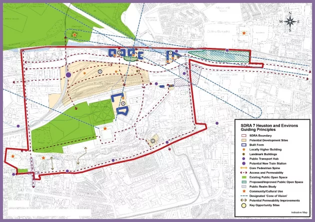
Introduction
Heuston station is Ireland’s largest multi-modal public transportation hub and anchors the wider SDRA area. The SDRA has the capacity to deliver a significant quantum of development and can become an exemplar of Transport Oriented Development.
The following guiding principles shall apply to this SDRA:
Urban Structure
- To develop a new urban gateway character area focused on the transport node of Heuston Station with world class public transport interchange facilities; vibrant economic activities; a high-quality destination to live, work and socialise in; a public realm and architectural approach of exceptional high standard; and a gateway to major historic, cultural and recreational attractions of Dublin City.
- To ensure the application of best practice urban and Transport Orientated Development design principles to achieve:
- Enhanced infrastructure to encourage active mobility interfacing with the various public transport modes at Heuston.
- A coherent and legible urban structure within major development sites.
- A prioritisation on the provision of public space.
- A successful interconnection between development sites and the adjacent urban structure.
- To recognise and enhance the role that civic and historic buildings play in the identity and legibility of the Heuston area.
- To provide greater accessibility to the areas of large public open space as well as creating additional smaller scale parks and civic squares, throughout the SDRA, that are attractive, multi-functional, safe, welcoming and accessible to local residents, workers and visitors.
- To recognise the acute barriers to connectivity created by a natural features, physical infrastructure and large landbanks of industrial or institutional lands and seek to reduce the impact of these obstacles to movement and connectivity, where appropriate.
- To seek to provide interventions that contribute a finer grain to the urban structure of the wider area, especially on some of the transport depots of Heuston station and Conyngham Road, if and when they are subject to change over time.
- The ‘cone of vision’, as set out in the 2003 Heuston Framework Plan, represents a significant panoramic view between, the Royal Hospital Kilmainham and the Phoenix Park extending from the west corner of the north range of the Royal Hospital Kilmainham, and the north-east corner of the Deputy Master’s House to the western side of the Magazine Fort and east edge of the main elevation of the Office of the Director of Public Prosecutions (former Royal Military Infirmary) respectively. Where there are opportunities for locally higher buildings within this ‘cone’, they must not individually or cumulatively adversely affect this view. A visual impact analysis shall be submitted with planning applications to demonstrate this view is not undermined. This shall also apply to the visual connections from Chesterfield Avenue to Guinness Lands and from the City Quays to the Phoenix Park (Wellington Monument) as indicated on the Framework.
Land Use & Activity
- To realise the creation of a new mixed-use district focused on sustainable modes of transport through the regeneration of the Heuston lands that incorporates a mix of residential and office uses complemented by culture, retail and service elements.
- To promote the regeneration and revitalisation of the Kilmainham Mill for civic, cultural, and visitor use.
- To facilitate connections between the cultural landmarks throughout the area – including the Royal Hospital Kilmainham, Kilmainham Gaol, Kilmainham Mill, National Museum Collins Barracks and the Phoenix Park.
- To recognise the need for community uses and public spaces to complement the future residential and office development in the Heuston area.
Height
- To support locally higher buildings of 8-10 storeys as a benchmark height for new developments in the SDRA area where conservation and design considerations permit, including assessment requirements under the Cone of Vision. Opportunities for locally higher buildings with a slender profile and landmark forms above this height, are identified in the accompanying Guiding Principles Map.
- Opportunities exist for landmark buildings at the Heuston Gateway at Sean Heuston Bridge on the former Hickeys site, and to the west of Steevens Hospital in line with the considerations outlined in Appendix 3 of the development plan. The potential locations for landmark buildings are shown on the accompanying Guiding Principles Map.
Design
- To undertake a public realm study for Kilmainham and Islandbridge villages.
- To provide for the possibility of public realm and transport interchange improvements to be made to the lands to the front of Heuston Station having regard to its important location as a gateway into the city, its proximity to heavy rail and Luas stops and its placemaking potential on Victoria Quay. Opportunities relating to the Guinness Lands’ role in placemaking and the public realm at this location should also be explored (see SDRA 15).
Green Infrastructure
- To facilitate the re-imagination of the River Liffey and the Camac River as key amenity and biodiversity corridors.
- To support the re-naturalisation of the Camac River.
- To ensure the Military Stream from Phoenix Park to River Liffey is protected and appropriate flood mitigation measures in place to prevent any flood issues.
- To implement the delivery of greening and biodiversity corridors identified in the Guiding Principles Map that that can also serve as high quality pedestrian and cycle routes and connect public open space provision.
- To ensure that the public open space provision of development sites be sited at locations that are visible, accessible and inviting to the wider public.
- To examine the possible consolidation of Croppy's Memorial Park, the Dublin Civil Defence HQ and the Croppy's Acre Memorial Park into a unified park.
Movement
- To facilitate the delivery of the permeability interventions identified on the Guiding Principles Map which seek to increase accessibility throughout the area and in particular, to the network of walking and cycling infrastructure that is emerging throughout the SDRA.
- To improve connectivity north-south across the River Liffey and St. John's Road through the Heuston lands to provide for road connectivity between Infirmary Road and Conyngham Road and also east-west between the Heuston lands and the Clancy Quay lands.
- To improve the pedestrian and cycle connection between Heuston Station and St. James's Healthcare Campus and to explore the potential of providing increased connectivity between Kilmainham Lane and Mount Brown/Old Kilmainham.
- To facilitate delivery of cycle routes identified in the NTA GDA Cycle Strategy.
- To maximise the potential benefit of the BusConnects project to the Heuston area in terms of public realm improvements, green infrastructure and pedestrian and cycling infrastructure.
Guiding Principles for Key Opportunity Sites
1 - Hickeys
Development on this site should provide active frontage to Parkgate Street with active non-residential landuse along this frontage. A riverside walkway should be provided and public access to the river should be allowed at all hours of the day.
Heights should be 6-8 storeys on this site while locally higher buildings could be located to the rear of the site at the identified locations. The site is suitable for the accommodation of a landmark building in the order of 30 storeys at its eastern end subject to the quality of the design and considerations being in accordance with Appendix 3 of the development plan
2 - Conyngham Road
The bus depot lands offer the opportunity to provide for improved integration with the River Liffey and to deliver a quality urban development. 10% provision of public open space should be provided at the waterfront in the longer term, forming part of an east-west greening and biodiversity corridor along the northern bank of the Liffey. Access to this public open space should remain open to the public at all hours of the day.
A culverted stream transverses this site. In this regard, a site specific flood risk assessment and appropriate flood mitigation measures will be required as part of any future development.
Although the north-south connectivity routes are indicative, road connections as per the overall guiding principles of the SDRA between Conyngham Road and St John’s Road/Military Road could be accommodated in the redevelopment of this regeneration site. Any vehicular bridge to the Heuston lands should be accessed towards the western end of the site. A cycle and pedestrian bridge should line up with the junction with Chesterfield Avenue unless design requirements in the context of the overall site redevelopment indicate a shift eastwards is necessary
Base heights should remain in accordance with prevailing heights along the Conyngham Road frontage where new buildings should respond to the character and grain of the historic buildings on site and the streetscape in which they sit, with the potential for increased height further to the west in accordance with Appendix 3.
The restoration of the vacant and neglected buildings on the south side of Conyngham Road is a matter of priority for the SDRA.
The opportunity for locally higher buildings exists away from the Conyngham Road frontage where buildings of 12-14 storeys could be provided subject to a visual impact analysis having regard to the Cone of Vision and compliance with Appendix 3 of the development plan.
3 - Heuston
Given the scale of the site and its redevelopment potential, it is appropriate that in advance of any development proposal, a masterplan shall be prepared taking into consideration the wider area, the SDRA principles and addressing planned phasing. This masterplan shall be submitted with the first and subsequent applications for significant redevelopment in the area.
Redevelopment of the site should provide for east-west and north-south connections in the manner identified in the Guiding Principles Map and also link up any potential future transport hubs to the adjoining areas beyond the Heuston lands. Vehicular access to the site is to provide local access only, save for the connection to Conyngham Road indicated above.
Wider pedestrian and cycle connections linking the Phoenix Park to the Royal Hospital of Kilmainham lands both via Military Road to Chesterfield Avenue and also in the western alignment shown in the Guiding Principles Map should be explored and accommodated as part of the masterplan response.
A greening and open space masterplan shall also be provided identifying a network of public open spaces including civic squares and parks, throughout the Heuston lands, that are attractive, multifunctional, safe, welcoming and accessible to the wider public.
No less than 10% of the site area is to be provided as public open space and should connect in with a riverside greening and biodiversity corridor.
On these lands, where heritage considerations allow, including structures on the NIAH and DCIHR, and having regard to the Cone of Vision, it is considered that prevailing heights pursued should be 8-10 storeys. Locally higher buildings at certain locations in the Regeneration Site could be accommodated with a landmark building over and above these heights located at the identified point. The locations for such height should be developed through the masterplan process and in accordance with the principles set out in the SDRA and Appendix 3 of the development plan and having regard to the conservation objectives of the Cone of Vision.
A community/cultural facility of significance should be incorporated into any redevelopment of the lands.
4 - Heuston South Quarter
Development on this site should be around a central area of communal open space integrating the needs of the residents of the first phases of the Heuston South Quarter development.
Building heights should respond to the ‘Cone of Vision’ identified in the Guiding Principles Map. Within two years from the adoption of the Development Plan, a re-assessment of the Cone of Vision shall commence having regard to the national planning context requiring the need to accommodate increased densities on urban brownfield sites, and the landscape character for protection within the cone, such as landmarks, buildings, views, corridors, etc., identified and weighted.
5 - St. James’s St./Bow Lane West
Redevelopment of this site should provide activation to the linear walkway leading from St. James's St. to Bow Lane West through the provision of windows and doors opening towards the laneway, as well as balconies providing passive surveillance of the walkway below.
Figure 13-10:SDRA 7 Heuston and Environs