13.7 - SDRA 5 – Naas Road
13.7 - SDRA 5 – Naas Road
Introduction
A Local Area Plan (LAP) for the Naas Road lands was adopted by the City Council on 14 January 2013. The plan was extended for a further 5 years in 2018 and will expire in January 2023. The plan area covers approximately 100 hectares and contains a number of major brownfield sites. It occupies a strategic location on a gateway point into the city with good public transportation links to the wider metropolitan area. The remaining lands to be fully developed out covers an area of approximately 18 hectares.
Dublin City Council together with South Dublin County Council are currently in the process of preparing “The City Edge Project” funded under the Urban Regeneration and Development Fund (URDF) programme which is a new Strategic Framework Plan for the Naas Road, Ballymount and Park West area comprising of c. 700 hectares. The vision for the area is to create a mixed use and climate resilient high density urban quarter of the city, where citizens will be able to access affordable homes, live close to where they work, in an area home to outstanding public amenities and public transport services. The City Edge project will inform a new Statutory Plan to be prepared for this area over the life of the Development Plan.
The Naas Road SDRA sets out guiding principles for lands within the current Naas Road LAP and part of the future City Edge project. The guiding principles are in place to support development in the area pending the finalisation of the City Edge Project and Statutory Plan for the area.
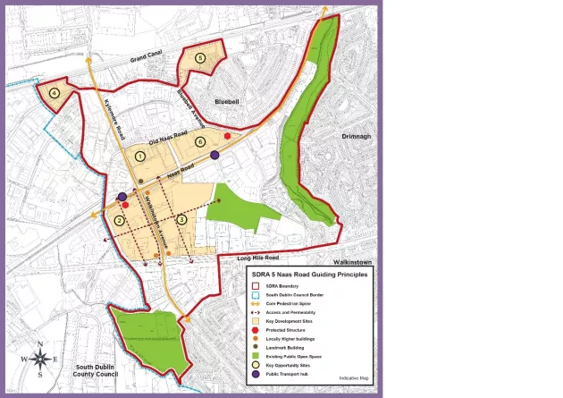
The SDRA contains six remaining key re-development sites, namely:
- Royal Liver Retail Park
- Motor Distributors Ltd site (Volkswagen factory)
- Nissan plant site
- Bluebell Avenue
- Former Bluebell Road Regeneration Area
- Naas Road Industrial Estate and surrounding lands
Linking the re-development of these sites into the wider surrounding environment, and creating sustainable successful communities is central to the successful regeneration of this SDRA.
Some of the key sites identified in the area have been the subject of planning activity in recent years, with permission for c.3,300 units in the vicinity of the Naas Road/Kylemore Road junction. The SDRA seeks to continue to support the redevelopment of the keys sites for mixed use development in the short term pending the adoption of a new LAP for the area.
Guiding Principles for Key Opportunity Sites
The Naas Road LAP provides guidance in relation to the development of the key opportunity sites 1-6 below, of which the key site specific issues updated and summarised below with said objectives being part of this SDRA going forward.
1 – Royal Liver
- To encourage the sustainable redevelopment of this key site as part of the mixed-use core of the Key Urban Village containing office and residential uses with local scale retail and service uses. To provide for a boulevard leading to a pocket park and pedestrian and cycling connections through the site to increase connectivity and deliver the green infrastructure network.
- To provide for a sustainable approach to height within the site, with buildings addressing the Naas Road and Kylemore Road providing a strong building line with appropriate heights, marked at the corner with a landmark building of up to 17 storeys. Within the site, heights will be at sustainable level, appropriate to the uses proposed.
- Require setbacks to be agreed with Dublin City Council along the main road frontages at Naas Road, along the east side of Kylemore Road to facilitate upgrading of the road to provide for a bus lane, segregated cycleway, greening of the route and footpaths allowing for an attractive and vibrant street environment and to encourage pedestrian and cyclist activity.
2. Motor Distributors Site
- Facilitate the sustainable redevelopment of this key site with a fine urban grain and a mix of uses as part of the mixed-use core of the Key Urban Village all at sustainable densities within a vibrant and interesting environment and integrating with the wider plan area and the administrative area of South Dublin County Council directly adjoining and aligning with the City Edge Project when adopted.
- Require a general height of between 6 and 8 storeys fronting onto Walkinstown Avenue, Longmile Road, Robinhood Road. There is potential for one to two mid -rise buildings (up to 50m) within the site.
- The height of new development along Naas Road, directly adjacent to the protected structure, should protect the special character and its setting.
- Require setbacks along the west side of Walkinstown Avenue and north side of Long Mile Road to facilitate widening of the road to provide for a bus lane, segregated cycleway and footpath allowing for an attractive and vibrant street environment and to encourage pedestrian and cyclist activity.
- Facilitate landuses that introduce active frontages and enliven the streets along Walkinstown Avenue, Long Mile Road and along priority pedestrian routes running through the site. Such uses may include local services such as retail, cafes, restaurants, leisure, cultural and community uses, reception areas to commercial areas above and other complementary active uses. Design of all units at street level should have a strong urban edge, convey openness and contribute to vibrancy in the public realm.
- Require the provision of a flexible and publicly accessible facility for community and cultural uses, and for any development proposal to include a community and cultural audit. Dublin City Council will, in consultation with local stakeholders, identify suitable uses for the facility. The form, size and other details of this/these space(s) shall be designed in consultation with Dublin City Council and will become part of the resources of Dublin City Council to support community and cultural activities in the city.
- Require the provision of a pocket park/performances space.
- Retain the Volkswagen premises (protected structure ref. 5792) as a landmark and formal entry point to the city and ensure the enhancement and protection of the special interest and character of the structure in any refurbishment, adaption or reuse; regard to be had to Dublin City Council’s upcoming guidelines on protection and refurbishment of buildings of the late twentieth century once published.
- Improve views of the Volkswagen Premises (protected structure ref. 5792) from the Naas Road by incorporating a strategically placed pedestrian access point into the northern boundary treatment of the site, incorporating a redesign of landscaping and an appropriate lighting scheme. This pedestrian point should allow for easy access to nearby bus stops and the Kylemore Luas stop.
- Provide for a predominantly pedestrian and cyclist-orientated environment at street level. The majority of car parking shall be provided at basement or at under-croft levels provided such under-croft parking does not undermine the objective to provide for active street frontages. A limited amount of well-designed car parking shall be facilitated at surface level subject to good design, integration with the street and broken up with landscaping and/or street furniture.
- Provide for a clearly defined arrangement of public spaces which integrate into the emerging pedestrian / green routes and cycle network for the plan area and beyond and that increases permeability throughout the site by incorporating clearly defined east-west and north-south pedestrian and cyclist-friendly routes through the site framed by buildings on both sides and containing active street level uses along these pedestrian routes allowing for passive supervision.
- Provide for a boulevard traversing the core of the site in an east-west direction integrating with the boulevard to be provided on that key site to the east of Walkinstown Avenue (the Nissan site). This space shall accommodate pedestrian, cyclist and vehicular movement but will be so designed so as to prioritise pedestrian and cyclist movement. This boulevard shall incorporate street art, furniture and planting, SuDS and shall be an attractive space for relaxation. The boulevard shall be overlooked by residential units on some upper levels and fine grain neighbourhood-level retail units, cafes, cultural uses and other complementary uses at ground floor levels.
- Assist in promoting modal shift to sustainable modes of transport by enhancing connections between the site and the Kylemore Luas and Dublin Bus stops by reserving road space for a setdown for buses on Walkinstown Avenue, by incorporating new pedestrian access points in boundaries of the site and provide for enhanced pedestrian crossings over the Naas Road, Walkinstown Avenue and Long Mile Road.
- As part of the redevelopment of this site the 750mm watermain may need to be diverted. Such a diversion would be at the expense of the developer(s).
- To retain existing mature trees and planting on this key site, in particular those trees along the site’s northern boundary and the tree line located in the southern section of the site, where feasible and appropriate.
3. Former Nissan Site
- To facilitate the sustainable redevelopment of this key site with a fine urban grain and a mix of uses as part of the mixed-use core of the key urban village, all at sustainable densities within a vibrant and interesting environment and integrating with the wider plan area.
- Require a general height of between 6 and 8 storeys fronting onto Walkinstown Avenue, Longmile Road and Naas Road; and two locally buildings of up to 15 storeys, one at the junction of Walkinstown Avenue and Long Mile Road, and one at the junction of Walkinstown Avenue and Naas Road.
- Require setbacks (to be agreed with the planning department) along the main road frontages at Naas Road, along the east side of Walkinstown Avenue and north side of Long Mile Road to facilitate widening of the road to provide for a bus lane, segregated cycleway and footpath allowing for an attractive and vibrant street environment and to encourage pedestrian and cyclist activity.
- Facilitate landuses that introduce active frontages along the Naas Road, Walkinstown Avenue and Long Mile Road, and priority pedestrian routes running through the site. Such uses may include local services such as retail, cafes, restaurants, leisure, cultural and community uses, reception areas to commercial areas above and other complementary active uses. Design of all units at street level should have a strong urban edge, convey openness and contribute to vibrancy in the public realm.
- Require the provision of a flexible and publicly accessible facility for community and/or health uses and a crèche in any redevelopment of this site to serve the needs of the residents in the area.
- Provide for a pedestrian and cyclist focused environment at street level. The majority of car parking serving commercial schemes shall be provided at basement or at undercroft levels provided such undercroft parking does not undermine the objective to provide active street frontages. A limited amount of well-designed car parking shall be facilitated at surface level (particularly within residential areas) subject to good design, integration with the street and with landscaping and/or street furniture.
- Provide for a clearly defined arrangement of public spaces which integrate into the emerging pedestrian/green routes and cycle network for the plan area and beyond and that increases permeability throughout the site by incorporating clearly defined east-west and north-south pedestrian and cyclist friendly routes through the site framed by buildings on both sides and containing active street level uses along these pedestrian routes allowing for passive supervision.
- Provide for boulevards traversing the large site in an east-west and north-south direction integrating with the local green links running through the site and integrating with the boulevard to be provided on the key site to the west of Walkinstown Avenue (the Motor Distributors site). This space shall incorporate street art, furniture and planting and SuDS, and shall be attractive space for relaxation. The boulevard shall be overlooked by residential and commercial on upper levels with ground levels dominated by retail units, cafes, cultural and/or community uses and other complementary uses.
- Assist in promoting modal shift to sustainable modes of transport by enhancing connections between the site and the Kylemore Luas and Dublin Bus stops by providing for new pedestrian access points in all three boundaries of the site and providing for enhanced pedestrian crossings over the Naas Road and Walkinstown Avenue.
- To green and improve the major road arteries surrounding this key site i.e. Naas Road, Walkinstown Avenue, and Long Mile Road, to include wider footpaths, additional tree lines (incorporating native species), soft landscape zones, additional pedestrian crossing points, and off road cycle routes.
- To seek the undergrounding of the 110 KV and 38KV high voltage overhead cabling traversing the LAP area. The route for undergrounding the cables will be assessed by ESB Networks with the applicants/developers, and in that event the cost of the undergrounding of the lines including associated civil works would be borne by the developers and ESB.
- To provide a new HV substation within the site, integrated with the undergrounding of cabling to meet the level of demand.
- As part of the redevelopment of this site the 750mm watermain may need to be diverted. Such a diversion would be at the expense of the developer(s).
4 - Bluebell Avenue
It is considered that the two parcels of land, located on the northern and southern side of Bluebell Avenue, have the potential to deliver a mixed use development and that this should be the subject of a masterplanning process. The development of the northern portion of the site shall include an adequate setback from the Grand Canal and take account of the conservation zoning.
5 - Former Bluebell Road Regeneration Area
This c.2.8 Ha site currently accommodates the existing Bluebell Road maisonettes development as well as the former Irish Water site adjacent to the Grand Canal. The maisonette units have reached the end of their lifespan and require either retrofitting or rebuilding. The overall site has the potential to deliver a significant quantum of residential development, in association with the regeneration/redevelopment of the maisonettes site.
It is considered that given the scale of the site and the locational context that heights of up to 10 storeys could be delivered on the site subject to detailed design, conservation considerations and being in accordance with Appendix 3 of the development plan. A masterplan shall be developed for the site. The masterplan shall address, but not be limited to, the following areas:
- Appropriate interaction with and consideration of the Grand Canal and associated conservation area.
- Consideration of the industrial heritage merits of the filter beds.
- The potential for the Luas extension to Lucan to be incorporated through the site.
- The potential undergrounding or design mitigation of the existing ESB power lines on the western end of the site.
- Identification of locations suitable for locally higher buildings.
- The redevelopment of the Former Irish Water and Bluebell Road regeneration area will be informed by the Bluebell – A Framework for Renewal Plan.
6 – Naas Road Industrial Estate and Surrounding Lands
These lands currently comprise of existing industrial / warehouse units bound by the Old Naas Road to the north and the Naas Road to the south. The lands also include a protected structure (RPS Ref. 5793) located on the eastern portion of the site at the junction of the Old Naas Road and Naas Road. The regeneration of these lands shall be subject to the preparation of a Masterplan to ensure an appropriate mix of uses and development strategy is set out to guide future development. The Masterplan shall have regard to the vision for the City Edge Project and any future statutory plan. Any future development should also ensure the character and setting of the protected structure is safeguarded. The provision of open space and green infrastructure along the route of the Camac shall also be safeguarded and provided for in the Masterplan.
Figure 13-8: SDRA 5 Naas Road