13.12 - SDRA 10 – North East Inner City
13.12 - SDRA 10 – North East Inner City
Introduction
The NEIC SDRA has an area of 161ha and is located in the city centre just north of the River Liffey, extending from the historic Moore Street area, on its western side, to Docklands, on the east. It includes areas to the east of Dorset Street and extends to some areas north of the Royal Canal. Given the significance of this area and its regeneration potential, Dublin City Council is committed to preparing a Local Area Plan for this SDRA during the lifetime of this development plan, and, therefore, this SDRA forms an interim strategy and sets guiding principles for the LAP.
The NEIC is rich in heritage with a number of significant cultural and historical attractions including Abbey Theatre and Parnell Square. The area has excellent public transport connectivity due to its proximity to the city centre, and will also benefit from the proposed Metrolink and ongoing development of the Royal Canal Greenway. The area clearly has many location advantages and is home to long established business and a diverse residential community. It is however, an area with a history of socio-economic deprivation and is identified as being in need of both social and economic regeneration.
The area is undergoing transformation with a number of initiatives being implemented on foot of the Mulvey report titled “Creating a Brighter Future”. The area has also recently received funding for a number of projects under the Urban and Regional Development Fund (URDF) including public realm works at Parnell Square, Moore Street, the Five Lamps and also restoration works at Moore Street and Mountjoy Square.
There is now an opportunity to focus further on realising the potential of the area, to complement the above initiatives and promote quality development on underutilised sites, alongside planned public realm improvements. This can be done in a way which recognises the unique characteristics and needs of this area. The main focus will be on the regeneration of identified key sites in accordance with site briefs. Key objectives are:
- To provide a spatial framework for land uses including much-needed housing.
- To restore a coherent urban structure where it is poor or fragmented and improving the public realm.
- To support community development through targeted objectives on selected sites.
- To plan for improved connectivity and public amenity while utilising existing assets in the area.
- To support the protection and enhancement of the unique historic character of the area through refurbishment and regeneration of the North Georgian Core.
The area is unique in having the benefit of varied assets including:
- O’Connell Street, the capital’s main thoroughfare, with the GPO (including museum); the core retail areas of Henry Street and North Earl street along with a range of retail services, food and beverage offer.
- A range of heritage and cultural assets including Hugh Lane Gallery, the Writers Museum, the LAB and Dancehouse.
- Moore Street to the west of the SDRA, famed for its on-street trading and linked to significant historic events of 1916.
- Parnell Square and Mountjoy Square, both Georgian era planned squares.
- Proximity to Croke Park, which fronts the Royal Canal, an emerging strategic greenway.
- Many historically important sites that contribute towards the area’s character, some of which also have significant future potential.
In conjunction with other development plan objectives, targeted objectives for the NEIC can make a positive contribution towards placemaking and future physical and social regeneration, whilst simultaneously fostering the growth of established inner city residential neighbourhoods and communities.
The following guiding principles apply to the NEIC SDRA:
Urban Structure
- To reinforce the existing pedestrian spines identified in the Guiding Principles Map and to capitalise on these through targeted permeability interventions, increasing connectivity and stimulating pedestrian journeys throughout the area.
- To recognise the amenity and placemaking potential that exists within the Royal Canal corridor and associated development sites and to undertake an urban design study looking at how to unlock this potential.
- To develop four civic hubs as focal points of local activity, including one with a strong community focus, centred on Sean McDermott Street around the former Convent and Laundry site and the Sean McDermott St. Leisure Centre/Our Lady of Lourdes Church site (see also below).
- To recognise the importance of the architectural and cultural heritage of the area including existing and proposed Architectural Conservation Areas centred on O’Connell Street, North Great Georges Street, Moore Street and Mountjoy Square.
- To create a hierarchy of public open spaces including civic squares and parks, throughout the NEIC that are attractive, multi-functional, and accessible to local residents, workers and visitors. Associated with this will be an enhancement of existing open spaces. This approach will help to address the existing deficit in public open space within the SDRA.
- The necessary regeneration of some social housing blocks will provide an opportunity to improve the human scale of the existing urban structure. Redevelopment of these blocks should integrate an urban grain that recognises historic plot sizes of the location.
- To encourage mews development in the locations identified in the Guiding Principles Map. This will provide greater activation along these lanes and facilitate greater use by pedestrians. Appropriate public lighting should be targeted at these locations.
Land Use & Activity
Overview
The area is centrally located and contains a range of diverse uses including residential, employment, and mixed use areas. It also accommodates a core retail area, many specialist services, cultural/arts uses and various institutions. Some areas have been zoned Z14 in recognition of the strategic regeneration potential of the area and to encourage an appropriate integration of new development into the urban fabric. A key objective of the SDRA is to ensure the sustainable consolidation of the NEIC working with existing assets, and integrating the full potential of a range of sites. An indicative framework addresses these sites graphically, with associated text set out to guide their future development. Some of these sites can work either individually or together for quite specific purposes, and these have been identified as ‘hubs’/ ‘opportunity sites’ below. There are four of these as follows:
O’Connell Street/Moore Street Civic/Cultural Hub –In recognition of the historic built form and history of the area and the potential for public interaction given its key location in the north retail core. With proximity to the emerging cultural quarter around Parnell Square, and its associated range of arts and literary attractions, this hub would act as a natural extension to the existing cultural quarter extending its reach, blending with a new mix of uses. With excellent transport access, this precinct will become even more accessible to the wider public when planned public transport improvements are delivered over time. The Moore Street market will become a re-energised market street, with a significantly improved public realm and act as a gateway, and through route, to the historical assets of the area, to create synergies to benefit the entire city block, breathing new life to the area. (*The historical assets are not limited to Moore Street/Moore Lane, but include O’Connell Street & the GPO)
Sean Mac Dermott Street Civic/Community Hub –Centred around existing and future community/ social facilities for the surrounding residential communities. It supports revitalisation of these services based on a new built layout in accordance with the framework. An associated upgraded public realm would comprise a new civic space and thus a focal point for the local community.
Five Lamps Civic Hub- Centred around a mix of established housing complexes and protected structures with part frontage to the Royal Canal at the well-known local, city and national landmark, the Five Lamps, a five armed road junction. The framework layout will restore an attractive built layout and provide for appropriate infill with suitably reconfigured open space, and enhanced permeability. Aldborough House can become a focal point for the local community.
City Gateway Civic Hub – Immediately adjoining the SDRA for the Docklands and serves as an entry point to the inner city and also an access to the employment lands of the Docklands SDRA. It’s positioning on the River Tolka at Annesley Bridge, overlooking Fairview Park, gives the hub capacity for large scale developments. Its regeneration will work in tandem with an identified regeneration site 6 within the Docklands SDRA, where a planned locally higher building will provide a clear visual marker.
Housing
- To promote an increased residential population and the successful integration of new and established residents and communities.
- To ensure that new residential developments accord with the indicative layout illustrated in the framework, supporting social, community and amenity infrastructure/services in the local area.
- To promote a variety of house types and tenures, avoiding an over-concentration of specialist accommodation such as tourist and student accommodation, thereby, ensuring capacity for the growth of balanced residential communities.
- To promote the development of high quality residential mews dwellings at appropriate locations and in accordance with relevant standards, thereby, unlocking the residential potential of laneways, improving public realm, and increasing pedestrian permeability where possible.
Social and Community Infrastructure
- To support the development of the URDF funded Community Centre which includes an exhibition space, at the disused former school premises at Rutland Street, and any future URDF funded projects within the area.
- Further to the Mulvey Report recommendations, to support, (a) the diversification of the sports facilities available in the area (in conjunction with DCC’s Sport and Wellbeing Partnership), including the provision of new outdoor playing space, (b) the development of facilities that encourage participation in the arts.
- To investigate the potential of an existing underperforming site adjacent to the Belvedere Youth Club on Buckingham Street Lower (as identified in the Mulvey Report) for expansion of existing services, subject to future feasibility studies.
Education and Employment
- To encourage local employment, where the appropriate skills are available, on construction projects in the area.
- To support the use of educational buildings within the area for evening and weekend use in the provision of education related services and recreational use.
- In association with relevant agencies, to encourage the development of Social Enterprise in the area by promoting the development of new enterprise space / starter units in appropriate locations.
- To support the development of a heritage/tourist/ literary trail (as identified in the Mulvey Report) in association with relevant agencies such as Tourism Ireland, Waterways Ireland, the NTA , and in consultation with key stakeholders.
Open Space and Recreation
- The provision of public open space on development sites should, where possible, be at locations that are visible, accessible and inviting to the wider public.
- To examine the possibility for the open space at St. Francis Xavier Church to become available for public patronage.
- To promote the regeneration of Mountjoy Square to improve its amenity potential.
- To carry out an audit of recreation and sporting facilities within the SDRA area to help identify areas of potential deficit.
- To seek appropriate public realm improvements in the prime retail core area, to include enhanced open spaces and provision of public seating.
Height
Extending from the historic retail core, through Georgian squares and connecting with the edge of Docklands, the NEIC is diverse in terms of built fabric and character. This variety of built form reflects both the diversity of uses in buildings and also the various architectural eras during which these buildings and public spaces were built. This context, as referenced in various planning designations, is important in determining appropriate building heights, yet there is considerable scope for variety in height across the area.
A range of sites within the SDRA are suited to regeneration and some of these are either sufficiently large or suitably located to define their own character. These can generally absorb some additional height. Height guidance is provided here for selected key development sites, informed by urban design principles responsive to context, and with appropriate locations for enhanced height identified within each site (see Guiding Principles Map). These taller elements, in addition to facilitating increased density, provide a basis for varied architectural expression and in some cases, have the potential to punctuate the established local heights whilst avoiding significant negative impacts (see Appendix 3). This additional height should be expressed vertically, and where forming part only of a larger building, should not extend horizontally along the block such that its visual prominence is flattened.
All new development of significant height and density over the prevailing context must accord with the specific performance criteria as set out in Appendix 3 of this development plan.
Design
The NEIC area is diverse in regard to built form, the varied design reflecting a diversity of land uses appropriate to this central location. The area also includes some vacant sites, underutilised or infill sites, and some sites of significant heritage value. This context affords considerable scope for significant regeneration, and the following shall apply in relation to buildings/complexes, and spaces:
- New buildings/schemes in the area shall necessarily have regard to the framework guidance set out. This is especially relevant to specific strategic sites in relation to building heights, building lines, public spaces and other specified parameters. A masterplan requirement will apply for some larger strategic sites.
- A high-quality public realm will be required and shall be applied to the network of streets and public spaces, with a focus on maximising public open space provision, improving connectivity/permeability and encouraging greening initiatives.
- High-quality architectural design and building materials will be encouraged throughout the SDRA. Architectural variety shall be encouraged, and contextual urban grain shall be considered, particularly for infill development. Flexibility will be applied in relation to design style provided there is appropriate regard to built context and relevant policy.
Green Infrastructure
- To support the implementation of the projects identified in the North East Inner City Greening Strategy and seek to address the deficit of public open space it identifies. For other areas within the SDRA, to promote greening initiatives and the upgrading of existing open spaces.
- To implement the delivery of greening corridors identified in the Guiding Principles Map that that can also serve as high quality pedestrian and cycle routes and connect existing and planned public open spaces.
- To facilitate the reimagining of the Royal Canal as a key public amenity and biodiversity corridor.
- To create a new public garden as part of the regeneration of the convent buildings on Sean McDermott St. and as a central amenity within this planned hub.
- To investigate the removal of car parking spaces in front of the Rotunda Hospital building on Parnell Street, and the conversion of this area to a high quality publicly accessible open space appropriate to its unique setting.
Movement & Transport
- To strengthen the existing core pedestrian spine of the area as both the key movement corridor and also the location of existing and emerging public transport hubs, and to specifically target interventions such as densification and street upgrades towards streets with low footfall and regeneration potential.
- To deliver public realm improvements at Five Lamps/Charleville Mall, Moore St. Quarter, Parnell Square and also at the proposed Sean McDermott Street civic/community hub.
- To encourage development that provides interaction and vitality of permeability interventions identified in the Guiding Principles Map. Own door access to ground floor units to be provided along all routes as well as balconies at upper floor levels. All of these new/improved routes are required to be publicly accessible at all hours of the day, unless significant reasons require the contrary.
- To facilitate delivery of cycle routes identified in the NTA GDA Cycle Strategy.
- To work with the Bus Connects project in the NEIC area to help maximise improvements in public realm, green infrastructure and pedestrian and cycling infrastructure.
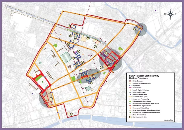
Guiding Principles for Key Opportunity Sites
O’Connell Street/Moore Street Civic/Cultural Hub
1 – O’Connell Street to Moore Lane incorporating Carlton Site
This 2.2 ha site incorporates buildings extending from O’Connell Street, Ireland’s premier street, to Moore Street, including Moore Lane, O’ Rahilly Parade, Henry Street North and Henry Place. It is identified within the Guiding Principles Map as a civic/cultural hub because of both its historical/cultural importance and because of its potential as a focus for quality retail and mixed-use development. The site is of significant historical importance given its association with the 1916 Easter Rising, and Moore Street is also well known for its open-air fruit and vegetable market. The area has the potential to be transformed through heritage-led, mixed-use regeneration that acknowledges and responds creatively to the cultural roles and historical significance of this centrally located site.
Scheme design shall be based on a comprehensive masterplan that incorporates a convenient access route to the planned Metrolink stop, quality connections across the site, and a cultural interpretative element.
Any final proposal must incorporate at least one new east-west pedestrian route interlinking to at least two new civic spaces within the block, utilising the existing lane structure for cross connections.
Masterplan proposals should hence incorporate the following:
- New pedestrian connections linking both O’Connell St. to Moore St. via a new public square, and also Henry Street to Henry Place/Moore Lane.
- Exceptional architectural design to match the importance of this city block that will effectively interlink the historic GPO with the emerging cultural quarter at Parnell Square.
- A new civic square, open to the public, and quality pedestrian access to the proposed Metrolink station.
- An appropriate mix of uses to ensure activity both day and night. Active ground floors should front public routes.
- The restoration of a significant element of the Upper O’Connell Street streetscape, including the former Carlton Cinema façade, No 42 O’Connell Street, and Conway’s Pub on Parnell Street.
- Heritage –led retention and restoration of all pre-1916 buildings and fabric along Moore Street.
- Acknowledge the urban architectural and historical context and complement the scale and design of the National Monument at Nos. 14 -17 Moore Street and its reuse as a commemorative visitor centre (URDF government funding relates).
- Moore Street Public Realm Renewal works to include lighting, public art, paving, stalls, signage (URDF government funding relates).
- Promote a high quality street market that firstly offers a diverse food range, speciality food with outdoor seating serving same that knits with the proposed Public Realm Renewal works proposed for the area and secondly a high quality urban environment that promotes a mix of uses, including residential at upper levels to ensure passive supervision and continual activity.
- A detailed phasing plan to address different stages of construction, co-ordinated as necessary with other planned works that may take place during the planned construction period.
Proposals for this area must also have regard to:
- The policies and provisions of the O’Connell Street Architectural Conservation Area (ACA ), 2001, and the Scheme of Special Planning Control for O’Connell Street & Environs 2016, including any amendments thereto, along with those of the proposed Draft Moore Street Architectural Conservation Area or similar where adopted.
- Protected Structures (as provided on the City Council’s Record of Protected Structures (RPS)) and the policies and objectives of this development plan for such structures, together with the provisions of the Architectural Heritage Protection Guidelines for Planning Authorities (2011).
- Ministerial Recommendations for the proposed addition of buildings and other structures to the City Council’s RPS, provided under Section 53 of the Planning and Development Act, 2000 (as amended), together with the relevant policies and objectives for same in this development plan.
- The content of the Moore Street Advisory Group’s 2021 report to the Minister.
2 - Lands to west of existing Hotel off Jones Road
This parcel of land fronts the Royal Canal and includes no buildings but provides temporary car parking to the west of the existing Hotel off Jones Road. The site presents an opportunity for well integrated development benefitting from views over the Royal Canal.
Any future redevelopment of this site shall investigate access from both Drumcondra Park to the west and Jones Road to the east, and should maximise pedestrian access options. The indicative building line should follow a courtyard layout with a linear southern elevation overlooking the Royal Canal, ensuring a degree of passive supervision. A central communal open space should be provided. Building height to the south of Russell Avenue shall take into consideration impacts on the residential amenities of the existing two storey housing. Amplified height can be accommodated on the south eastern corner of the block where impacts on amenities would be least, this element providing visual variety as seen from the Royal Canal. That the provision of community facilities such as a children’s’ playground and/or community garden be incorporated/included in any future development.
3 - Russell St/North Circular Road
These lands have significant regeneration potential and are well located along both the Royal Canal corridor and the North Circular Road. Regeneration of the site should seek to retain and integrate existing buildings of heritage. Any redevelopment should provide built edges to its three street frontages, while a setback should be provided along its northern boundary to create a more generous interface with the Royal Canal. Permeability through the site should connect up its four bounding edges and public access should be maintained at all hours of the day. A masterplan shall be prepared in relation to proposals on this site, addressing stated requirements and setting out planned phasing.
Amplified height has been identified in the Guiding Principles Map. The south-east corner can absorb a locally higher buildings due to its visual prominence and location at a key juncture while at the other locations, the enhanced height should be designed so as to be less visible from neighbouring streets. Built form along the Russell St. and Portland St. North edges should respond to the existing built form character of the dwellings opposite with respect to scale and grain.
4 - Lands to the south of Croke Park Stadium
These lands currently facilitate entry to southern Croke Park stands, with a crossing over the Royal Canal and railway line and an associated car-park sandwiched between existing housing to the west along Russell Street and O’Connell School to the east.
There is potential for regeneration of this underutilised site, which has clear benefits of being both secluded and also positioned on the Royal Canal Greenway. Redevelopment is largely dependent however, on the removal/relocation or undergrounding of the existing carpark, which is encouraged. Were this achieved, there is an opportunity to develop a substantial development. There can be flexibility regarding the block layout provided the design incorporates:
- A direct pedestrian connection from the scheme to the Canal Greenway and enhanced public realm in this area.
- Connectivity to the southern side, linking the scheme to both Wellesley Place, and St. Margaret Avenue/St Joseph’s Terrace.
- To create and implement a quality public realm scheme for Jones’ Road to animate the street, and help provide passive surveillance of the canal.
5 - Fitzgibbon Street Flats
Any redevelopment of this existing flat complex should seek to restore the building line along road frontages to both Fitzgibbon St. and North Circular Road. A strong edge should also be presented to Fitzgibbon Lane (to rear of properties on Belvedere Place), which in tandem with development of mews units as illustrated in the framework graphic, will help to activate and enliven the laneway. Own door access to ground floor units to be provided at all three frontages.
6 - Charles St. Great
The redevelopment of this vacant site, in tandem with development of mews units on the opposite side of Charles Lane, will help to activate and enliven this lane which interconnects Fitzgibbon Street and Charles Street Great. Redevelopment of the site should provide a strong built edge along all three street frontages with own door access to all ground floor units. The Tyrell Place frontage should comprise townhouses or duplexes responding to the fine grain Victorian terraced housing opposite, and appropriately integrated into the remaining development.
7 - Matt Talbot Court
Any redevelopment of this flat complex should seek to restore the building line along frontages to Charles St. Great, Sean O'Casey Avenue and Summer Place, with own door access to all ground floor units. Development at Sean O'Casey Avenue should respond to the scale and grain of the existing terraced buildings on the street. A north-south pedestrian street through the site should be provided for, lining up with Charles Lane to the north. This approach ensures an improved integration of the site with its built surroundings.
8 - Bus Depot, Summerhill
This site has strategic regeneration potential due to its scale and setting and because new through routes can improve connectivity to existing housing. Should it be redeveloped, two north-south connections should be provided through the site. The first along its eastern boundary with a second connecting Mountjoy Place to Summerhill via a linear public park. This second route could form part of a wider cycle network. An east-west connection should be provided for at the north of the site, extending Gardiner Lane to meet Summer Place. Limited increased height on either side of this park provides an opportunity for architectural variety in the scheme, with associated urban design benefits.
Sean McDermott Street Civic/Community Hub
The designation of this hub is to provide a renewed focus for the local community based around publicly accessible uses in an appropriately designed setting. It builds on some established uses and buildings, and works with the potential of underutilised sites to create a fresh identity and improved urban integration. The role of sites 9, 10 and 11 are set out below in regard to how this could be achieved.
9. Lands on the Northern side of Sean McDermott Street
This site has strategic regeneration potential and should form the focal point to a new civic/community hub focused on Sean McDermott Street, incorporating varied community uses, a civic plaza, and improved permeability. Current uses include a public swimming pool and Our Lady of Lourdes Church. Should the site be redeveloped, it should provide two north-south connections through the site, allowing for the development of three separate blocks, the central one forming a perimeter block. Development parallel to the western boundary should respond to the scale and amenity of the properties to the west.
The two new connections should run through substantial linear green spaces between the blocks. An east-west connection should also be provided for at the north of the site, connecting Gloucester Place Upper to Rutland Street Lower, and enhancing permeability for the wider area. Given the prominence of this site and established community uses, the quantum of civic/community uses on the site should not be reduced as a result of any redevelopment. A civic plaza should be created providing a new focal point to the wider Sean McDermott St. area and be fronted by active, non-residential uses at ground floor level. This should be designed so as to engage with the future use of Site 10 opposite.
10 - Convent Lands, Sean McDermott St.
As a former Magdalene Laundry, it is a site of great historic importance. Its regeneration and refurbishment should marry the conservation and cultural heritage qualities of the lands with the opportunity to provide activation and renewal of the Railway Street interface, thereby, enhancing public realm. The area will be the location for a National Centre for Research and Remembrance. As an integral part of this work, the provision of an appropriate memorial will be investigated with key agencies and stakeholders. An internal garden/courtyard befitting a site of its cultural significance should be designed to be accessible and inviting to the public. Also, two north-south connections through the site should be provided at the locations indicated on the Guiding Principles Map, to tie into the more strategic connections through the area. These should provide throughways that are visible and legible on approach, the routes designed with sufficient width to avoid creation of narrow alleyways. See also CUO10, Chapter 12.
11 - Railway Street
An infill site that should provide a built edge along its western and northern frontages. This will frame a side of the planned pedestrian route extending north-south through multiple sites. Own door access should be provided at ground floor level on both frontages.
Five Lamps Civic Hub
The illustrated five lamps civic hub incorporates assets such as the Royal Canal, nearby Charleville Mall library, and historic Aldborough House, and takes in three regeneration sites numbered 12-14 inclusive hereunder. The illustrated framework, through the provision of improved pedestrian connectivity, restored building lines, and a pocket park, provides an opportunity to build on these assets, redefining the area’s identity.
12 - Aldborough House
Aldborough House, a Georgian era protected structure, is located at a visually prominent position near the five lamps junction. Despite the building being in poor condition at present, it nevertheless has potential to become a focal point for the area given its historic character and visual presence. This is dependent on it being restored back into viable use either with or without new development on the site. Any future proposal must recognise the historic merits of the site and carefully consider the setting and conservation of the building and associated structures.
13 - Backlands and Health Centre site at Portland Row/North Strand Road.
This site is one of three interconnected sites and includes some underutilised backlands north of Portland Road, and also a HSE Health Centre at North Strand Road.
The regeneration of this underused site has potential to sensitively develop backlands, restore building lines and improve connectivity through the wider block. The indicative site layout effectively provides for optimal use of former depot lands, with townhouses recommended adjacent to some existing housing, and a new centrally positioned block unlocking an area of backlands.
Any redevelopment of the Health Centre element of the site creates potential for a new building that provides a stronger building line and corner to the street at North Strand Road, and demolition of the City Council block of flats just north of the Health Centre (along with rehousing of the residents) can help provide space for a new public square of open space, helping reduce the current shortfall of open space in the area. A new street interconnecting Portland Row through to North Great Clarence Street could then provide an alternative connection to the busy North Strand Road.
14 - Clarence/Dunne Street Flat complexes
This existing Dublin City Council flat complex, comprising three detached blocks in a staggered layout, is of a poorly integrated layout and provides an opportunity through any future redevelopment, to create new building lines enclosing a new public through route, which would connect well to adjoining regeneration sites and also provide direct routes to the main thoroughfares.
An improved street design, with parallel linear building lines, has potential to provide passive supervision of the new public realm. New blocks should be designed to protect the residential amenities of nearby pre-existing housing, and the new street should be tree-lined.
15 – Lands off Richmond Street North, south of the Royal Canal
Accessed from Richmond Street North, off the North Circular Road, these are largely underutilised or undeveloped lands at a location that fronts the Royal Canal, close to Croke Park to the north. Regeneration of this site has potential to provide improved permeability for the wider area, and to also ensure a degree of overlooking of the Royal Canal amenity route.
Any proposed layout should demonstrate the permeability connections illustrated in the framework. In this regard, a direct publicly-accessible connection should be provided from North Richmond Street through to the Canal, and there should also be a link from the site directly to Richmond Parade to the east. New built frontage to the Royal Canal should provide passive supervision for users of the canal hence enhancing public realm for both residents and canal users. Amenities of existing residential development around the site, including at Richmond Parade, should be carefully considered in regard to scheme layout and design/scale.
16 - North Strand/Poplar Row
These underutilised lands have significant regeneration potential. When considered in conjunction with developable lands on the opposite side of North Strand Road (located in the Docklands SDRA), their redevelopment has potential to deliver a new 'gateway' civic hub at the crossing of the Tolka River moving towards the city centre. This site is located within a protected Tidal Flood Zone A from the Tolka River. A Site Specific Flood Risk Assessment should be carried out for a redevelopment of this site.
Redevelopment of this North Strand/Poplar Row site should provide a built edge along all three street frontages, while enhanced height could be provided for along the Poplar Row frontage, at a position set back from the corner. Development immediately at this corner should respond to the prevailing built form character along this section of North Strand.
17. Abbey/Peacock Theatres
The Abbey Theatre has played a pivotal role in Irish theatre though history at this central location. It is now in need of redevelopment/expansion in order to meet modern standards and to ensure adequate space for associated activities including offices and rehearsal spaces. To meet this aim, the council support the redevelopment of the existing Abbey Theatre and Peacock Theatre buildings and adjoining sites to create a vibrant new cultural quarter with high quality architecture and public realm that maximises linkages and frontage to the River Liffey.
Figure 13-13: SDRA Northeast Inner City