13.8 - SDRA 6 – Docklands
13.8 - SDRA 6 – Docklands
Introduction
This SDRA corresponds to the Dublin Docklands area as defined by the Dublin Docklands Development Authority Act, 1997. It extends to circa 520 hectares and has significant potential for further regeneration with a number of key development sites throughout the area. These sites can make a valuable contribution to the future physical and social regeneration of this part of the city, consolidating the area as a vibrant economic, residential, cultural and amenity quarter of the city, whilst simultaneously nurturing sustainable well-integrated neighbourhoods and communities.
There are two existing development frameworks that relate to the majority of this area, the North Lotts and Grand Canal Dock Planning Scheme and the Poolbeg West Planning Scheme. Remaining development sites will be informed by the guiding principles set out below.
Urban Structure
Given the variety of urban fabric within this SDRA, a focused approach is necessary, taking account of existing characteristics and regeneration opportunities. The objectives for urban structure within the existing SDZ areas are set out in the relevant planning schemes. These are supplemented by guidance for selected key development sites (see opportunity sites section below), located outside of the SDZ areas. These key development sites represent opportunities for the integration of new development, addressing such matters as permeability, building lines, heights and greening opportunities. This approach will ensure integration into the historic fabric of the city and create opportunities for increased interaction and mobility within the Docklands and the wider city, thus encouraging social cohesion.
The SDRA benefits from immediate proximity to the NEIC SDRA, an area for which guiding principles have also been prepared and in which various urban initiatives are being implemented.
Land Use and Activity
Given the scale and diversity of the Docklands area, future land uses will accord with the focused requirements of the relevant SDZ Planning Scheme, or (for remaining areas) the development plan zonings. The overall approach aims to encourage mixed use development in order to achieve a balance between residential and commercial uses, with other community and cultural uses encouraged throughout. Below are separate guiding principles relating to the following thematic areas: Housing, Social & Community Infrastructure, Education and Employment and Economic Activity.
Housing
- To promote the expansion of the Docklands’ residential population, and the successful integration of residents and communities.
- To ensure obligations under Part V and Dublin City Council’s housing strategy are met.
- To provide physical, social and amenity infrastructure in tandem with new housing.
- To ensure that residential developments work with the unique character of Docklands in terms of visual context, maritime location, heritage assets and community identity.
- To promote a mix of house types and tenures to increase the population, promote social inclusion and integration and support the existing services and businesses in the area.
Social and Community Infrastructure
Social sustainability is central to the regeneration strategy for the Docklands area. Dublin City Council will actively pursue a community and social development agenda, integrating and connecting the Docklands communities. A Social Infrastructure Audit of the Docklands area (SDRA) conducted in 2015 was reviewed in 2017. This helps guide social and community development in the area. The Poolbeg West Planning Scheme was adopted since this audit and contains relevant objectives for the SDZ with regard to social and community infrastructure. Key guiding principles for the SDRA under this theme are:
- To pro-actively engage and re-integrate the Docklands community with the full spectrum of Dublin City Council services, with particular regard to the Council’s community services which include children and young people, community development, social inclusion and interculturalism, community and voluntary, as well as public private partnerships of socio-economic interests.
- To support recommendations of the document ‘Dublin’s Northeast Inner City – Creating Brighter Future’ insofar as it relates to the Docklands area, and also to support the recommendations of the ‘2017 Review of Dublin Docklands Social Infrastructure Audit 2015’.
- To ensure co-ordination between the various statutory and non-statutory providers of social services and social programmes in the Docklands area.
- To ensure that social and community facilities, in particular educational facilities, are provided in tandem with residential development, having regard to the over-arching social infrastructure audit and related 2017 update.
- To require the provision of space in large-scale developments for social, cultural, creative and artistic purposes.
Education
- To promote the provision of educational programmes for the local community in conjunction with third-level institutions, including the National College of Ireland, Trinity College Dublin and Technological University (TU) Dublin.
- To liaise with the Department of Education and Skills (DES) in supporting the important services provided by existing schools in the Docklands area, especially in relation to the pivotal role of schools in community development.
Employment & Economic Development
The Docklands area has witnessed significant economic development over the past number of years with noticeable growth in the financial, IT and professional services sectors. There has been significant spin-off benefits for the local community. The Eastside and Docklands Local Employment Services Report (2020) highlighted the importance of efforts to help align economic development with job opportunities for the unemployed through the provision of appropriate courses. Local employment will continue to be encouraged on construction projects and job placement programmes in local schools supported. In this regard, progress on educational attainment and local employment levels in the Docklands area will be monitored over time. Guiding principles for the area include:
- To promote the Docklands as a location for sustainable businesses and supporting services and to support the marine economy.
- To encourage innovation that supports sustainable economic development, including an innovation district on lands at Grand Canal Quay, to be developed by Trinity College.
- To encourage local employment, where the appropriate skills are available, on all construction projects, and to promote a local schools job placement programme.
- To promote sustainable tourism including cultural, recreational and business tourism. To also support Fáilte Ireland in implementing the aims of its Docklands Visitor Experience Development Plan (2020) including various projects promoting sustainable tourism.
- To recognise the significance of Dublin Port Company’s non-statutory 2040 Masterplan, and related updates/reviews, as an important guiding document for the future of port lands.
- To implement the non-statutory Water Animation Strategy for the NL&GCD SDZ (2018), and to ensure (working in conjunction with Dublin Port Company and Waterways Ireland) that the River Liffey remains navigable between the East Link Bridge and Samuel Beckett Bridge.
- To support Smart Docklands in its work with the city, innovators and the universities, in progressing innovative technological solutions that can help transform how the city operates and improve quality of life.
Height
Existing building heights in the area vary considerably. Suitable heights for any given site are influenced by urban design principles with regard to existing built context, national guidelines, conservation issues and setting. In relation to the SDZs for North Lotts and Grand Canal Dock and Poolbeg West, specific height requirements apply as set out in the Planning Schemes, where heights are set out for individual city blocks or elements within them.
More generally for the SDRA area, Ministerial guidance published in 2018 has redefined a planned approach to building heights which is now to be implemented, and this SDRA has clear locational advantages that support some increased height in appropriate locations.
General height guidance is provided for selected key development sites in the SDRA, informed by urban design principles responsive to context. More specifically, appropriate locations for enhanced height within key sites are identified, with specific positions illustrated within indicative site layouts. These taller elements can contribute towards visual variety and help define an area’s character whilst avoiding significant negative impacts on amenities. They can also provide for greater architectural expression. For clarity, these taller elements can be up to one third taller than the dominant height of the main building, as measured from ground level. This additional height should be expressed vertically, and where forming part only of a larger building should not extend horizontally along the block such that its visual prominence is flattened.
In some more limited locations where the planning context is suitable, locally higher buildings of greater height and landmark buildings can be appropriate, and positions for these buildings are clearly described for key sites.
All new development of increased height compared to the existing context must accord with the specific performance criteria as set out in Appendix 3 of this development plan.
Design
For the SDZ areas, the matter of design is addressed in detail in the relevant statutory planning schemes. In the case of the NLGCD SDZ, a Public Realm Masterplan has also been completed along with a related public realm implementation guide (2018). Detailed design specifications are also set out for Poolbeg West in the Planning Scheme. In relation to the wider the SDRA area:
- A high-quality public realm will be required and shall be applied to the network of streets and public spaces, with a focus on greening initiatives, maximising public open space availability, and improving connectivity and passive surveillance.
- High-quality architectural design and building materials will be encouraged throughout the SDRA, as will visual variety.
- Broad design parameters are set out, where appropriate, for the redevelopment of specific strategic opportunity sites set out below. A masterplan requirement will apply for some larger strategic sites.
Green Infrastructure
- Support the implementation of the projects identified in the North East Inner City Greening Strategy that pertain to the Docklands area.
- Provide for new streets as set out in the framework plan, accommodating an improved pedestrian environment, cycleways and green infrastructure/SuDS interventions.
- Provide for a new park along the Royal Canal between Sheriff St. and Newcomen Bridge.
- Promote greening initiatives in association with sustainable transport connections both to, and through the port area, improving connectivity to key destinations.
- To promote the provision of public open space at locations within key development sites that are visible, accessible and inviting to the wider public.
- Support green infrastructure/connectivity initiatives contained in the Ringsend and Irishtown LEIP and improve connectivity to Poolbeg West SDZ.
- Provide for the creation of connected recreational and amenity spaces in Poolbeg that strengthen the biodiversity and ecology of the area, with a particular focus on Sean Moore Park and Irishtown Nature Park.
- To promote and facilitate the delivery of the Port Greenway and to enhance the amenity of East Wall Road through tree planting, improved pedestrian facilities, and potential expansion of quality public realm.
- To support and promote that expansion of water-based activities including slipways, pontoons and marinas.
Movement & Transport
- To enhance public realm to accommodate increased pedestrian movement.
- To support the upgrading of the Campshires to deliver an improved environment for cycling and walking, along with necessary flood relief works.
- Facilitate the delivery of the sustainable transport initiatives identified, including new pedestrian and cycle bridges at specified locations in accordance with SMTO23 including:
- Bridge from North Wall Quay at Point Depot (Point Bridge) and the widening of Tom Clarke Bridge, improve pedestrian and cycling facilities at the crossing point as well as accommodating additional public transport routes in conjunction with the Dodder Bridge.
- Pedestrian/cycle bridge crossing the Liffey between the Samuel Beckett Bridge and the Tom Clarke Bridge.
- To facilitate delivery of cycle routes identified in the NTA GDA Cycle Strategy.
- To support the extension of LUAS light rail, a DART Interconnector and improvements to Irish Rail’s network including Dart+ projects.
- To include an objective for the reservation for a public road linking the national road network at the Dublin Tunnel to serve the southern port lands and adjoining areas (Southern Port Access Route) in accordance with the NTA Transport Strategy for the Greater Dublin Area 2022 – 2042.
- To reconfigure Sean Moore Roundabout to a signalised junction and provide for greater accessibility of the Poolbeg West SDZ area with the city centre. This will seek to address issues of severance with the Ringsend area.
- To improve sustainable transport connectivity both to and through the area of Dublin Port.
- To support public realm improvements in East Wall to enhance permeability and connectivity to the wider area.
- To support increased animation of water bodies in the NLGCD SDZ in co-operation with relevant agencies and stakeholders, through the identification of areas to be used for particular on-water uses.
- To provide for a Luas stop and line on the south east side of the Sean Moore Road.
Implementation
A multidisciplinary team at DCC will continue to progress the implementation of policy and objectives for the Docklands area, working with relevant stakeholders and (DCC) Area Office staff, and monitoring progress and project phasing. In addition, the Docklands Oversight and Consultative Forum (DOCF) is a statutory body appointed by the Minister that may advise DCC and any Strategic Policy Committee on any Docklands related functions.
Outside the boundaries of the two SDZs there is a need to address continued socio-economic regeneration and urban integration. As part of this ongoing process, a series of large sites have been identified as having particular potential, and guiding principles have been set out to assist with their sustainable redevelopment and integration into the city fabric.
In relation to development elsewhere, there is merit in further work on other non-strategic sites and, therefore, it is recommended that the western part of the Docklands area that is included within the NEIC boundary be included in any future LAP for that area.
A Local Environmental Improvement Plan has been prepared for the Ringsend/Irishtown area. It sets out local improvement projects including works for Ringsend Library square and recommendations for various interconnecting linkages. In 2021, under the Urban Regeneration and Development Fund, funding was approved by the Department of Housing, Local Government and Heritage for works at Library Square, at Sean Moore Road/Roundabout and Cambridge Road. Redevelopment works at Ringsend Park are also approved.
Guidance for North Lotts and Grand Canal Dock and Poolbeg SDZ’s
North Lotts and Grand Canal Dock Planning Scheme 2014
The North Lotts and Grand Canal Dock (or NLGCD) Planning Scheme, adopted in 2014, sets out a holistic template for the sustainable development of this area (c. 22 ha) for a mix of commercial and residential uses. The Scheme also planned an integrated framework for new infrastructure such as bridges, parks and public spaces as well as the upgrading of the Campshires and animation of the river Liffey and canals.
Since the SDZ was adopted, significant progress has been made, with the majority of the vacant sites now either built out or under construction. At the time of writing, the only entire City Blocks where no development has taken place on foot of the Scheme are 18-20 inclusive. The quantum of commercial development either under construction or complete has now exceeded the indicative floor area set out for the overall Scheme. In addition, permission has been granted for 97% of the target number of residential units. New public spaces and streets have been provided in accordance with requirements and more are progressing. Significant specific objectives have been met for the area. These include:
- The publication in 2017 of a Public Realm Masterplan for the SDZ area, and related public realm implementation guide (2018).
- A 2017 review of the Dublin Docklands Social Infrastructure Audit (2015).
- A water animation strategy (2018).
Significant progress has also been made in relation to infrastructure planning and design, and towards improved public realm. The Council will continue to work with the DOCF and all stakeholders towards the successful implementation of the Scheme.
Poolbeg West Planning Scheme 2019
In 2016, the government designated 34 hectares of lands at Poolbeg West as a Strategic Development Zone. This area included brownfield lands such as the former Irish Glass Bottle site and also lands owned by Dublin Port.
In 2019, following extensive consultation with the local community and stakeholders, the Planning Scheme was approved by An Bord Pleanála. It plans in detail for an appropriate mix of housing in order to create a socially balanced community, designed to sustainable densities and served by quality amenities and services. Commercial/office uses are also accommodated, with scope for up to 100,000 sq. m. The overall scheme is designed to encourage active travel through the availability of quality public transport and new cycle infrastructure, with minimal planned car parking. District heating will help towards energy efficiency and climate change goals.
Improvements to road access arrangements are needed to facilitate these new land uses, with local upgrades and a planned new public transport bridge over the river Dodder. At a more strategic level, improved port access and the Eastern Bypass route reservation are also accommodated. Because of the scale of development envisaged, a clear phasing plan has been set out, such that infrastructural requirements are provided in tandem with appropriate levels of new development.
Detailed block-by block design guidance ensures an appropriate level of certainty and gives clarity on the location and extent of quality public realm, including parks, street layouts and coastal amenities.
Guiding Principles for Key Opportunity Sites
1 - Connolly Station
As a key public transport interchange in the city centre, Connolly Station and its immediate environment has regeneration potential to deliver an appropriate density of development integrated with improved access to the station from nearby streets, and also a new public open space for the community. This site has potential for enhanced scale and height. Redevelopment should deliver permeability through the site to the wider street network, with access from Sheriff St. Lower to Seville Place and Oriel St. Upper. A new pedestrian entrance to the station from Preston Street through an existing rail arch should link to a central concourse and to the wider pedestrian network should be provided. All connections must be universally designed.
Public open space should be located at the southern edge where it is visible, accessible and inviting to those approaching from either end of Sheriff St. Locally higher buildings can be accommodated at identified locations adjoining the railway lines where residential sensitivities are lower. The other identified locations for locally higher buildings are such that views from Oriel St. Upper and Oriel Hall will be filtered by lower rise development to the foreground. Development along Oriel Street Upper should be designed with own-door ground-floor access and should be responsive to the low-rise residential character of existing development located opposite.
Given the location of the site on a major public transport interchange, proposals for a landmark building/s will be considered in accordance with the criteria as set out in Appendix 3, Table 4.
A masterplan shall be prepared for the entire site, incorporating the above objectives. This masterplan should also address the following in appropriate detail:
- Appropriate interface with CIE operations.
- Access, servicing and parking strategy.
- Approach to improved public realm along Sheriff Street.
- Rationale for building heights throughout the scheme.
- A Conservation Strategy for the arches, to include reopening of arches where possible, and conserved to an appropriate standard.
- A housing element to incorporate an appropriate housing mix, taking account of local housing need.
- Strategy to protect and enhance the character of the existing historic station building.
2 - Site between 52 Oriel Street Lower, the Royal Canal Greenway and the canal rail bridge
Any development on this site should seek to engage with the canalside, and development here could act as a wayfinder along the Royal Canal Greenway. The northern end of the site is adequately removed from sensitive land-uses to accommodate a locally higher building exploiting canal-side views. The existing entrance to the site from Ossory Street Lower should be opened up to provide public access to the canalside and the associated greenway. All dwellings at ground floor level should have own-door access and those located along the north-eastern boundary, should be orientated towards the canal. Requirements of Irish Rail shall be adhered to in relation to the built footprint and necessary clearances.
3 - Shamrock Place
The development of this site could both contribute to the animation of the Royal Canal Greenway and provide some locally higher buildings, particularly at the northern or eastern end of the site. This would provide passive surveillance of the canal-side, while also being cognisant of its close proximity to a low-rise street of Z2-zoned properties. All dwellings at ground floor level should have own-door access and those located along the north-eastern and eastern boundaries should be orientated towards the canal.
4 - Ossory Industrial Estate
Redevelopment of this site should provide a setback from Ossory Road, enabling a widening of the road to facilitate an improved pedestrian and cycle environment. Locally higher buildings could be located at the western corner, acting as a visual cue for those traveling in both directions along Ossory Road and to/from the Royal Canal Greenway. Public access should be provided to the site directly convenient to a proposed a new pedestrian/cycle bridge crossing the canal and parallel to the rail line. All dwellings at ground floor (or street) level should have own-door access and those located along the south western boundary should be orientated towards the canal. Requirements of Irish Rail shall be adhered to in relation to built footprint and necessary clearances.
5 - Coady's Yard, Ossory Road
Redevelopment of this site should provide a setback from Ossory Road, enabling a widening of the road to facilitate an improved pedestrian and cycle environment. Own-door access to ground floor dwellings fronting Ossory Road, should also be provided where feasible, to encourage ground floor activation. Requirements of Irish Rail shall be adhered to in relation to built footprint and necessary clearances.
6 - North Strand Fire Station/Former Readymix Site
A site of considerable strategic merit, located along a key movement corridor to the city centre and fronting the Tolka River and Fairview Park, this site provides an opportunity to accommodate a development of greater scale. Scheme design should carefully consider the residential amenities of existing properties on Leinster Avenue and Hope Avenue, which frame the site. Locally higher buildings located at the northern corner of the site could mark a key gateway into the inner city. Development should provide a strong edge to both street frontages while the North Strand frontage should accommodate non-residential uses at ground floor, promoting street activity and animation. A public pedestrian route through the scheme will interconnect an area of open space with the River Tolka, and this route should be of high amenity design, with the footway flanked by a landscaped green strip. All dwellings at ground floor level should have own-door access. Given the scale of this site, a masterplan shall be prepared for the entire area to address the above matters in addition to planned phasing.
7 - Docklands Innovation Park
Redevelopment of this site should incorporate public open space along its north-western boundary where it can serve as an amenity and improved setting for the adjoining primary school and punctuate this long road. Development should be set back significantly from the south-eastern side boundary to provide for an improved interface with Merchant's Road and the residential dwellings opposite. Adequate space should be reserved along the south-western boundary of the site for a pedestrian throughway in order to enhance connectivity through this large block, including to the local school. The specified locations for locally higher buildings are influenced by the placemaking benefits of framing public open space, by views from nearby residential properties being filtered by lower buildings, and by the need to maintain the amenities of the public street. All dwellings at ground floor level should have own-door access.
8 - Chadwick's Yard
Existing large warehouse-type structures and industrial yards dominate this site which has potential for complete transformation by way of a new street framework serving perimeter blocks surrounding a new public green. This scheme will complement planned development on the adjoining site at Docklands Innovation Park and have greatly increased permeability.
The scale and massing of development should form an appropriate interface where it adjoins existing residential properties (Merchant’s Road and Merchant’s Square). Opportunities for locally higher buildings exist at the identified locations that can provide urban design benefits, i.e. locations that help frame public open space and at a central node within the site where there would be limited overshadowing impacts. All dwellings at ground floor level should have own-door access. Given the scale of this site, a masterplan shall be prepared for the entire area, to address the above matters in addition to planned phasing.
A linear strip of land along the eastern side is reserved for the future South Port Access Route (SPAR) project in accordance with a reservation protected by TII. Hence lands within this reservation are unavailable for any development pending final detailed design of the route. Development proposals adjoining the road reservation shall meet the requirements of TII. Any lands within the reservation that are not needed as part of the eventual design for SPAR should revert to landscaped open space at a later stage and to the satisfaction of TII. This open space should function as an appropriate buffer to the new route. A revision to the above-mentioned masterplan will be allowed at a later stage in response to final design for the SPAR route and to clarify the future use of any remaining lands.
9 - East Road
At the north-eastern and eastern boundaries of the site, development should be orientated and massed to respond to the existing residential buildings on adjoining sites. Development along the southern boundary of the site has less sensitive interfaces and could accommodate a locally higher building. The other locations for locally higher buildings adjoin the public open space at the existing street edge and form a visual marker within the site with views across this space.
The site's public open space provision is positioned at its East Road entrance where it will be visible, inviting and accessible to the public at this arrival point to the East Wall area. All dwellings at ground floor level should have own-door access. Given the scale of this site, a masterplan shall be prepared for the entire area, to address the above matters in addition to planned phasing.
10 - Castleforbes Business Park
Redevelopment of this site should incorporate a large public open space at its western end where it will be visible, inviting and accessible to the wider public. Block layout should take into account the existing street and block layout further south including relevant content of the NLGCD Planning Scheme. Locally higher buildings could frame the public open space at a bend in the adjoining perimeter block layout. Two further locations have been identified for enhanced height at the northern end of the site where overshadowing impacts and visual sensitivities are lessened. Given the scale of this site, a masterplan shall be prepared for the entire area, to address the above matters in addition to planned phasing.
11 - Trinity College Innovation District
This site located north of the rail line between Macken Street and Grand Canal Quay, has potential to provide a new hub for innovation, teaching, research, collaboration, enterprise and support facilities bridging between the commercial activities in Docklands and research at Trinity College and enabling the development of a globally competitive innovation district for Ireland. This area can accommodate a broad range of uses associated with the primary function of this district, including business, enterprise/research, related residential accommodation, cultural and other supporting/enabling uses. A series of adaptable buildings shall display a variety of quality architecture, and these shall frame a centrally-positioned public square. This square shall have multiple public pedestrian accesses along generously proportioned circulation routes, including a diagonally positioned route connecting to the Macken Street/Pearse Street Junction, and connecting to the quay on the eastern side.
The interface with Pearse Street shall accommodate a transformed public realm, and on street parking provision shall be minimal. The existing historic Tower Building (original sugar mill) should be retained and potentially extended vertically by a maximum of 2-3 storeys, and public realm surrounding the building shall provide physical and visual linkages between the proposed central square and Grand Canal Quay. The approach to building height and design shall take account of established residential uses to the west and north, and also proximity to the Alto Vetro building. General site heights to range from 7 to 9 storeys with potential for some locally higher buildings.
There is potential for a landmark building/s within this site having regard to the surrounding context and emerging developments in the area.
The City Council will work closely with TCD and all relevant stakeholders to prepare a Masterplan for the phased development of the site that establishes high quality development objectives and parameters to ensure that an appropriate mix of uses are provided to support a working and resident community including cultural, recreational, retail and related uses.
12 - ESB Complex, South Lotts Road
Redevelopment of this site should provide for public open space at the western edge of the site, in a location that is visible, inviting and accessible to the public. This open space should be accessible from Margaret Place to the south, and more generally east-west and north-south connectivity though the site should be achieved. Building massing and orientation towards the western and southern sides of the site should respond to the built character of the adjacent residential streets, and this should include townhouse-type design along the western edge (these could be 3-storeys). All dwellings at ground floor level should have own-door access.
Some locally higher buildings could be appropriately located in the north-eastern quadrant of the site. Given the scale of this site, a masterplan shall be prepared for the entire area, to address the above matters in addition to planned phasing.
13 - George Reynolds House, Oliver Plunkett Avenue
Any redevelopment of this flat complex should involve a remodelling of the scheme to incorporate:
- delivery of perimeter block type layout to enhance communal open spaces, and
- new townhouses fronting Oliver Plunket Avenue to reflect the design and grain of the existing dwellings. Public open space would be best located at the Irishtown Road end of the site where it is visible, inviting and accessible to the wider public. All dwellings at ground floor level should have own-door access.
14. Former Power Station and Pigeon House Hotel, Poolbeg
The former ESB power station and Pigeon House Hotel are both protected structures accessed from Pigeon House Road on the northern side of Poolbeg Peninsula. Both buildings and associated structures are on a seven acre site currently in the ownership of Dublin City Council, and are in need of extensive refurbishment to bring them back into viable use. The site has potential for a landmark building/buildings. The lands are at risk from flooding – see Appendix 7, SFRA. Residential use is not the preferred use for these lands due to particular constraints including adjoining utility uses and the risk from flooding.
DCC has previously sought expressions of interest for the regeneration of these buildings and the associated lands. The Council support development focused on creative, technological and green industries. This has potential to restore activity to these historic buildings in this unique waterfront setting close to the city centre. In this regard, it is the objective of the Council to seek the regeneration of the former power station and Pigeon House Hotel, with associated lands/structures on this site. This will involve extensive refurbishment of these protected structures. Development plan/statutory designations are to be considered from early design stage.
15. Shelbourne Stadium, South Lotts Road
The subject site, located in a highly accessible area of the city and comprises of c. 3ha of urban lands suitable for strategic development and regeneration. The lands are capable of delivering a high quality mixed use development to complement and enhance both the existing land uses and future strategic plans for the area.
Any future development of the site should be subject to a Masterplan as part of the planning application process and should provide for a mixed use development comprising of residential, commercial and public open space. The building design and layout should respect the existing buildings to the north along Ringsend Road and the proposed future development of opportunity site 12.
Given the scale of the site, opportunities exist for the provision of some locally higher buildings and landmark buildings addressing the River Dodder.
Permeability interventions should be provided through the site from South Lotts Road to the River Dodder and from Ringsend Road through to opportunity site 12. A feasibility study, including the necessary environmental studies, should be prepared to assess the potential of a pedestrian footbridge across the Dodder connecting Ringsend Village and the Wider Docklands area. A public walkway along the bank of the River Dodder should also be delivered to enhance amenity value of the river at this location.
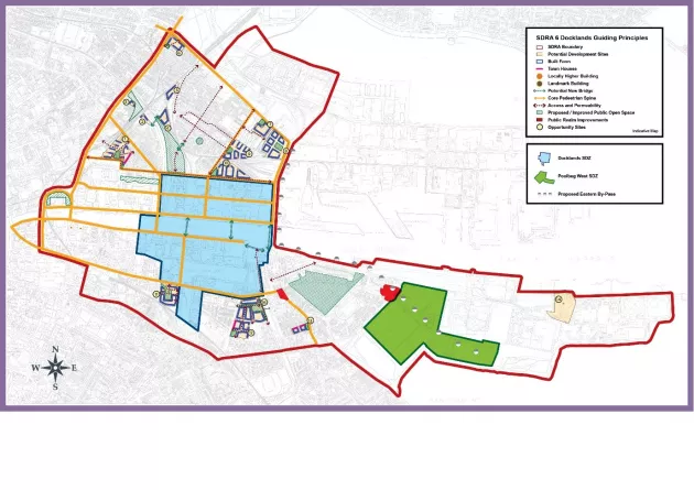
Figure 13-9: SDRA 6 Docklands