13.15 - SDRA 13 – Markets Area and Environs
13.15 - SDRA 13 – Markets Area and Environs
Introduction
The markets area, with the Victorian Fruit and Vegetable Markets building as the centrepiece, is rich in history, encompassing long established market and trading streets. The area, bounded by North King Street to the north, Capel Street to the east, Church Street to the west and lnns and Ormond Quays to the south, interlinks the historic Smithfield area with the core retail area to the east.
The area’s rich history and medieval origins is reflected in both the variety of current uses (which include residential, civic, commercial, religious and retail) and also in its historic street pattern and built fabric. The significance of the area is also recognised in planning designations, with an established Architectural Conservation Area (ACA) along Capel Street and a range of identified protected structures within the area, including the Victorian Markets building, Saint Marys Abbey, and the Four Courts complex, and the area’s inclusion in an area of archaeological interest. The area also has a number of low intensity and under-utilised sites, which offer potential for quality urban regeneration.
Recognising the area’s assets, this SDRA provides a framework to ensure a coherent and structured approach to the future development of the area by providing guidance for specific sites that can act as catalysts to drive sustainable regeneration. It is envisaged that this structured guidance for the SDRA will help realise the potential of the area, improving its integration with both the core retail area around Henry Street /Mary Street further east and with the Smithfield area to the west.
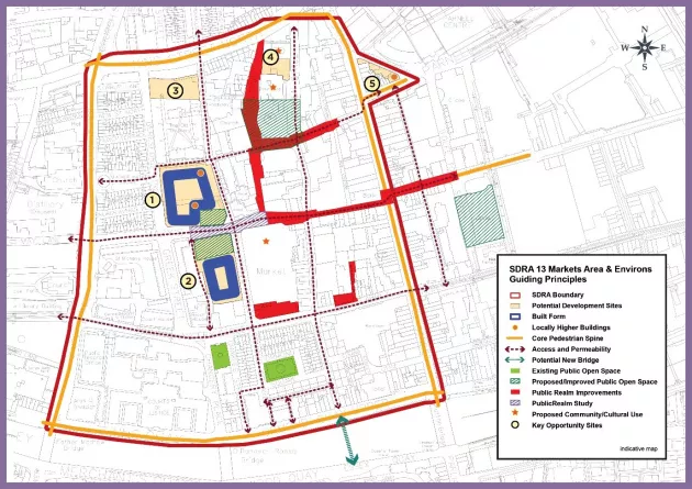
The guiding principles for SDRA 13 are as follows:
Urban Structure
- To realise the potential of the Fruit and Vegetable Market building as an iconic architectural, cultural and community centrepiece for a revitalised Markets area.
- To facilitate the wholescale regeneration of the public realm and pedestrian environment as identified in the Guiding Principles Map, and encourage development that contributes to the activation and upgrade of these spaces.
- To encourage the regeneration of the Markets area as a key component of the western expansion of the North Inner City core connecting the Henry/Mary St. area with Smithfield and to facilitate improved legibility and ease of pedestrian movement between the three areas.
- To recognise the strong character and historic built fabric of the area and support the retention and reuse of existing historic buildings of merit.
Land Use and Activity
Context and Land Uses
The majority of the lands are zoned ‘Z5’ reflecting the area’s central location suited to a variety of land-uses including both commercial and residential. Some areas are zoned for more specific purposes mostly to recognise the need to conserve architectural heritage in this very historic part of the city centre. These include lands around the Bridewell Garda Station, the Four Courts, Law Library and associated lands to which a Z8 zoning applies and buildings to the north of Saint Michan’s Park, including the Debtors Prison and courthouse building, which are all zoned Z8. Some older residential streets are zoned as residential conservation areas (Z2), including streets adjoining Church Street (which was built in response to the collapse of a tenement at Church Street and is one of the first Corporation housing schemes) and around Father Matthew Square/Ormond Square.
Capel Street and its historical commercial origins, is located within an Architectural Conservation Area, and the area from Beresford Street to Green Street, including a distillery building and also Saint Michan’s Church and along the Liffey Quays and buildings are outlined with the conservation area objective. (See Section 11.5.3)
Having regard to the above, a framework for redevelopment of underutilised sites needs to demonstrate sensitive integration whilst also generating new vitality. Opportunities for the creation of quality new green/open spaces as part of larger redevelopment projects can supplement existing spaces at Chancery Park, St. Michan’s Park and Ormond Square. There is also considerable scope for public realm upgrades which can both enhance the setting of these spaces and provide quality connections between key destinations. Opportunities also exist to support casual market trading in appropriate public realm areas subject to appropriate licencing.
Taking into account the designation of the SDRA as an area of archaeological interest, the significance of this area in medieval Dublin’s history and the rich archaeological material evident in this area; there is a presumption against basement development in all but exceptional circumstances.
Housing & Community
- To promote an appropriate mix and diversity of residential accommodation.
- To support community facilities serving the area, such as the Macro Community Resource Centre on Green Street, which provides an integrated facility for a range of community services and voluntary organisations.
- To support the provision of an appropriately located public civic space to serve the community.
Open Space
- To create an interlinked hierarchy of public open spaces and routes including civic spaces and parks, throughout the Markets area that are attractive, multi-functional, safe, welcoming and accessible to local residents, workers and visitors.
- To support the implementation of the projects identified in the Markets Public Realm Masterplan and encourage the provision of new open space on site as part of larger redevelopment opportunities where feasible; increasing the overall open space provision in the area.
Height
There is substantial variation in building height in this area, reflective of the area’s rich history and evolving range of uses. Scope for enhanced height is considered somewhat constrained due to the prevailing height, scale and fine grain of existing development, in situ archaeology, along with sensitivities associated with the Capel Street ACA, the extent of protected structures and designated conservation areas.
Landmark buildings are generally not considered appropriate in this SDRA. However, it is acknowledged that some of the larger regeneration sites, such as the “Total Produce” site have the potential to accommodate some increased height and locally higher buildings. The site at Ryders Row also has potential for locally higher buildings due to the setting at the junction of two busy streets.
Design and Green Infrastructure
- To support the implementation of the projects identified in the City Markets Public Realm Greening Strategy, to enhance biodiversity and amenity.
- To support the redesign of Saint Michan’s Park and associated public realm and amenity improvements.
- To exploit opportunities for street trees and low level planting.
- To encourage the installation of features referencing the route of the culverted Bradogue River in the public realm. This may be through creative use of materials, installation of signage/information boards, or through public art features.
Movement and Transport
- To reinforce the existing pedestrian spine identified in the Guiding Principles Map and to capitalise on it through targeted permeability interventions increasing connectivity and encouraging pedestrian and cycle journeys throughout the area.
- To facilitate increased pedestrian space on Capel St and throughout the area.
- To support an improved pedestrian route on Cuckoo Lane in providing a quality link route through the area; that respects the heritage materials of the Lane.
- To facilitate delivery of cycle routes identified in the Guiding Principles Map and the NTA GDA Cycle Strategy.
- To explore the provision of new cycling and pedestrian connections through the areas crossing the River Liffey and connecting to Fishamble Street.
Guiding Principles for Key Opportunity Sites
1 - ‘Total Produce’ Site
Development on this large site will require a sensitive approach that incorporates variation on each elevation to avoid monolithic built forms. Some boundaries for this site will need to set back to allow for the widening George's Hill and at Beresford and Mary’s Lane, and to facilitate adequate separation distances from the buildings opposite, whilst also preserving their character. The 10% allocation of public open space should be located at the south-east corner of the site where it can benefit from generous solar gain and the activation provided by the revitalised markets building.
Base height should be 6-7 storeys, where residential amenity considerations allow, while additional heights at the identified locations could reach 8-9 storeys at the south-east of the site and up to 12 storeys at the north-east of the site. Any height over the base level shall be confined to the illustrated locations, should be clearly defined architecturally, and should not extend substantially along the block.
2 - Fish Market Site
The regeneration of the Fish Market site allows for the development of a building of civic use as well as the provision of ancillary services to the market opposite. The redevelopment of the site should accommodate a new public space/continued amenity uses at the northern end of the site.
In time, such public open space has the potential to be visually continuous with that proposed for of the Total Produce site, and across Mary's Lane. This visual integration should be carefully considered at early design stage in regard to layout and materials.
Any redevelopment of this site could accommodate its current and emerging uses at basement or roof level, subject to related assessments.
3 - TU Dublin Site
This substantial site is positioned between a DCC housing project to the north and established residential development to the south. The building and lands are associated with the Technical University (TU) which is currently consolidating many of its educational facilities at its Grangegorman campus nearby. If redeveloped, the predominant land use should be residential. It could also accommodate alternative (and compatible) ground floor uses. The east-west orientation of the site could accommodate an L-shaped or U-shaped building block with a southerly aspect.
4 – Site adjacent to the Courthouse/Debtor’s Prison
This infill site, largely comprising a surface car park, lies between the Green Street courthouse and the Debtor’s Prison, both of which are protected structures of considerable historic and architectural merit and dating from the late 1700s.
Sensitive development of the infill space has potential to interlink the two heritage buildings and provide new or associated uses which could include exhibition space and or community/event space, hence facilitating public access and wider appreciation of these heritage buildings. There is also potential for a new green strip connecting to St. Michan’s Park to the south.
5 - Ryders Row
A site of considerable visual prominence, its redevelopment should contribute a building of significant architectural merit, befitting its location at a key nodal point and vista termination along Parnell Street.
With respect to built form and height, it should respond to the prevailing built form, character and grain of the established buildings to its west along Parnell St. However, at the corner it could accommodate a slender building of up to 6-8 storeys. Whilst outside the immediate SDRA boundary, the development of this site has potential to signal the route from Parnell Street through to the markets area.
Figure 13-16: SDRA 13 Markets Area and Environs