13.18 - SDRA 16 – Oscar Traynor Road
13.18 - SDRA 16 – Oscar Traynor Road
Introduction
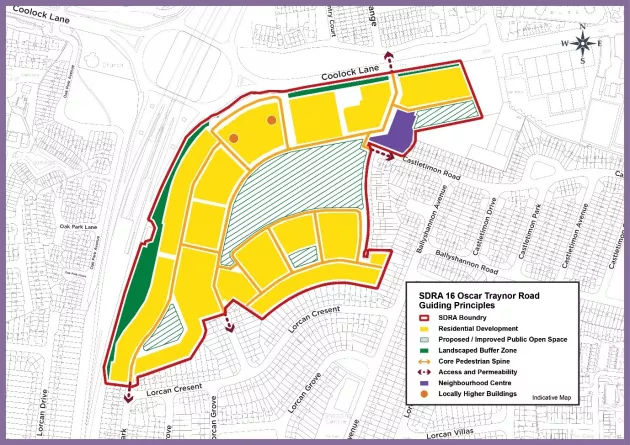
The Oscar Traynor Road SDRA (c. 17.2 ha) is located to the south-east of the junction of Oscar Traynor Road and the M1 interchange. The lands have a relatively flat topography, are currently vacant and covered in scrub vegetation. They are bound by the M1 / M 50 motorway / port tunnel entrance to the west, R104 Coolock Lane (Oscar Traynor Road) to the north, astro-turf football pitches and Gaelscoil Cholmcille to the north-east, Castletimon Gardens to the east, and the rear of two storey houses which front onto Lorcan Crescent to the south.
The overarching vision for this SDRA is to maximise the potential of a well-connected but underutilised low-intensity residential lands, situated within the existing built fabric of the city and the creation of a new high quality residential quarter with a neighbourhood centre and landscaped open spaces and parks, which integrates with its surrounding, mainly residential, environs. The site has an estimated capacity of 850 – 1,000 residential units in addition to community, recreational and retail facilities.
The following guiding principles will apply to the SDRA:
Land-use and Activity
- To create a planned residential quarter integrated with the surrounding established area and with enhanced permeability. A mixture of unit types and tenures including family housing will be promoted. The provision of senior citizens homes is also supported.
- To provide a new neighbourhood centre promoting a distinctive place-making component at the entrance to the site. It is envisaged that this will form a local hub within the site and accommodate local retail, services, crèche and community uses. The neighbourhood centre should integrate with a central park which incorporates the Naniken Stream as an integral feature.
- All development proposals are to adhere to development guidance on flight path, airport noise zone and public safety zones. See Chapter 15 Development Standards for further details.
Height
- To seek higher building forms at the northern and western edges of the site with heights in the range of 6-10 storeys being generally appropriate (subject to appropriate design considerations), scaling down to the east and south where the site adjoins existing 2-storey residential housing.
- The heights of buildings along the central park should be designed to respect the orientation of the park and should form a coherent civic frontage to the park. Careful design should be given to development adjacent to the motorway to minimise noise impact. A strong spine of higher apartment buildings presenting their ends to the motorway to optimise site orientation and create sheltered courtyard spaces may be appropriate.
Design
- To seek a high quality architectural design response to both individual buildings and streetscape settings/elevations for the entire site but having particular regard to the approaches from the M1 southwards and along Coolock Lane/Oscar Traynor Road. Elevational treatment and materiality that provides both variety and coherence will be promoted.
- To seek creative architectural solutions to single buildings such as the neighbourhood centre to ensure these buildings differentiate themselves from the mainly residential nature of the remaining site. High quality materials will be sought to boundary treatments and the public realm.
Green Infrastructure
- To provide a variety of high quality green spaces for a range of different users throughout the site including the main central park, pocket parks, private courtyards, nature trails along the perimeters etc. There is to be a minimum 20% of the site in public open space.
- To ensure that the Naniken Stream forms an integrated feature of the central park and that habitat ponds and a naturalised river section are included where feasible.
- To design the central park to include recreation spaces including play spaces for all ages, a skate park, outdoor exercise equipment etc. A network of paths that connect through and around it with direct and circular routes should be provided. Allotments and orchards should be included where feasible.
- To provide a new urban park connecting the Gaelscoil grounds with an urban play area located close to the school and accessed from the school grounds. This park should also contain:
- A bespoke play area.
- Outdoor games such as table tennis tables.
- A MUGA (Multi-Use Play Area).
- A pedestrian pathway to the school to facilitate the use of the park by the school.
Movement and Transport
- To provide high levels of permeability throughout the site integrating with existing residential streets to the east and south where feasible with pedestrian links to the north-west to connect with the western side of the M1 Port tunnel access route. Development should include permeable green routes through the site to make new connections to the wider community, adjoining school and to Coolock Lane.
- To provide for increased pedestrian safety and permeability including:
- A connected series of routes with a readable hierarchy leading to and through the central parkland.
- A new signalised junction on Coolock Lane to access the proposed development, the school and Astroturf centre. This proposed main access junction from Coolock Lane will incorporate a high quality pedestrian/cyclist facilities for those accessing the site.
- Pedestrian priority features with visual and speed reducing measures.
- Liveable, green, safe streets with a strong sense of place.
- Increased links to residential areas to the south via new pedestrian/cyclist linkages.
- Address existing east-west permeability and connectivity issues through potential future enhanced crossing facilities at the Coolock Interchange.
- Reduce walking distances between Beaumont Hospital and Coolock Interchange by improved permeability.
- Hierarchical approach to the use of materials, which will be used to reflect road hierarchy including changes to carriageway surface material to emphasise transitional zones and changes in material on raised table junctions to encourage low vehicle speeds.
- To upgrade the existing two-stage pedestrian crossing on Coolock Lane to a single stage toucan crossing. A toucan crossing will also be provided across the southern arm of the junction which will connect to a segregated pedestrian/cyclist route on the western side of the OTR access and a shared facility on the eastern side.
Figure 13-19: SDRA 16 Oscar Traynor Road