13.19 - SDRA 17 – Werburgh Street
13.19 - SDRA 17 – Werburgh Street
Introduction
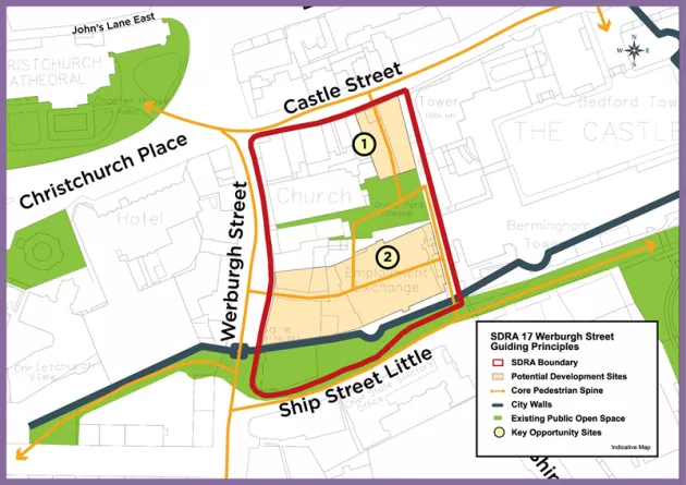
Werburgh Street SDRA is within the medieval city walls and defined by Castle Street to the north, Hoey’s Court (Castle Steps) to the east, Ship Street Little to the south and Werburgh Street to the west. The Dublin City Walls and Defences Conservation Plan 2005 identified the city walls as one of the most important civic monuments in the capital city.
A framework was prepared for Dublin City Council in 2005 to provide a coherent strategy for this historic core of Dublin City. This plan proposed urban solutions for key spaces that will act as nodes for growth and linkage between one another and the wider city. Werburgh Street SDRA is informed by the Guiding Principles Map and recent planning history of the area. The SDRA will seek to achieve a core quarter that will exhibit a strong physical character, recover lost history and building fabric and provide activities that have beneficial effect on the future of this part of the city.
The area contains a number of Recorded Monuments that survive above and below ground. The upstanding remains of the medieval city walls are a National Monument. St. Werburgh’s Church and graveyard is both a Recorded Monument and a Protected Structure and the three storey house at number 4 Castle Street is also a Protected Structure. Werburgh Street is the site of the Pole Tower (a medieval mural tower) assumed to be under the road near the entrance to Jury’s car park. The area is also unique in containing well-preserved deep layers of buried waterlogged archaeological deposits from the Hiberno-Norse town. These deposits are of International importance as they relate to the origins of European urbanisation and to an extensive Viking trade network. The protection, curation and interpretation of this sensitive non-renewable resource for future research is a key priority for the SDRA.
The guiding principles for the area are as follows:
Urban Structure
- To support the identity, historical and cultural significance of the city walls circuit and of the historic core of the city. To support the relevant objectives of the Dublin City Walls and Defences City Walls Conservation Plan.
- Proposals must acknowledge the status and integrity of the walled circuit as a single, composite entity and place the identity, significance and function of the city walls and defences at the heart of future regeneration of this area.
- To improve access and enhance the presentation and setting of the standing portions of the city walls at Ship Street Little.
- Any re-development to ensure the long term preservation of the archaeology, embrace and enhance the historical and cultural significance of the area to the city.
- Buildings within the prevailing height category (Appendix 3) will be considered, having regard to the conservation and archaeological sensitivity of the location.
Land Use & Connectivity
- The sensitive redevelopment of underutilised sites to provide additional mixed use offering complementing the cultural, tourism and recreational activities of the area should be pursued.
- To support the ecclesiastical and cultural use of St. Werburgh’s Church and improve access into St. Werburgh’s Church and graveyard.
- To provide a pedestrian-friendly space and to improve the entrance and connection into Dublin Castle from Werburgh Street along Ship Street, and from Castle Street via the Castle Steps.
- To provide a new wall walk looking over Ship Street.
- To open access to the wall walk from the existing gate on the Castle Steps (lower end).
Open Space and Amenity
- Having regard to the cultural tourism destinations within the wider area, the regeneration of the SDRA lands should improve the visual and open space amenity of the area for the local community and visitors and improve pedestrian connectivity between destinations.
- The River Poddle, runs below Ship Street in a Victorian culvert. The historic line of the Poddle is reflected by the upstanding City Walls on the north side of Ship Street. Proposals for Ship Street should provide an open plaza and prioritise pedestrian movement whilst celebrating the city walls and the grandeur of the historic precinct of Dublin Castle.
- To seek the development of a new ‘square’ or space to the south of St. Werburgh’s Church.
- To develop the lands adjoining the City Walls west of Werburgh Street as a landscaped area that supports local biodiversity whilst protecting the sensitive archaeological remains at this location; as a "meanwhile" use as until a full archaeological examination of this area takes place.
- To represent in some form the birth place of Jonathan Swift, (No. 9 Hoey’s Court), one of Ireland’s greatest satirists and authors
Design
There are two specific sites within the area that present an opportunity for re-development - see Guiding Principles Map. These sites are owned by the Office of Public Works (OPW) and are currently underutilised. Site 1 is a land bank currently in use as surface car parking on Castle Street. Site 2 is currently occupied by the Employment Exchange building located at the corner of Ship Street Little and the Castle Steps.
Proposals should ensure that the design for the sites should be of the highest architectural quality. Proposed structures should be light weight buildings with low impact foundations (i.e. under 5%) to allow for adequate in situ preservation of the archaeological deposits. The scale, massing and height of these buildings shall have due regard to the sensitive nature of the site, its monuments and historic setting.
Other infill developments in the area should be done in a sensitive manner. New developments should be of the highest quality design, materials and finish, with a density appropriate to the historic core and the medieval inter-mural status of the site.
It is the policy of Dublin City Council to continue to preserve, and enhance the surviving sections of the city walls and defences. Any proposal within close proximity (20m) of the city wall should have regard to the City Walls and Defences Conservation Plan. Any new use should be designed to have minimal impact on the subsurface archaeological deposits, and will be subject to Ministerial Consent, archaeological impact assessment and research-led excavation in accordance with the Medieval Dublin Archaeological Research Framework.
Green Infrastructure
New Developments shall include a green infrastructure strategy that provides amenity and biodiversity space in addition to surface water attenuation measures.
Figure 13-20: SDRA 17 Werburgh Street