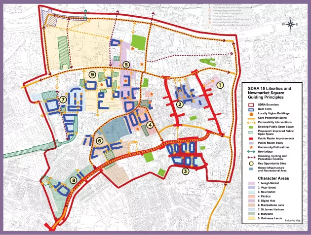
13.17 - SDRA 15 – Liberties and Newmarket Square
13.17 - SDRA 15 – Liberties and Newmarket Square
Introduction
This SDRA corresponds to the area defined by the Liberties Local Area Plan 2009. With the expiration of the Local Area Plan (LAP) in May 2020, the SDRA seeks to incorporate relevant elements of the LAP, as appropriate, that have yet to be realised.
While considerable urban consolidation and regeneration of the Liberties area has occurred in recent decades, significant opportunities for regeneration and enhancement still exist, as identified in the guiding principles for this SDRA. It is an objective of the plan to recognise the unique role the Liberties plays in Dublin’s character and to ensure that regeneration safeguards the Liberties’ strong sense of community identity and cultural vibrancy into the future.
The guiding principles for SDRA 15 are as follows:
Urban Structure
- To recognise the importance of the historical spine of the Liberties and its medieval street network.
- To identify permeability interventions to augment this network and also to restore historic laneways, where appropriate.
- To recognise and enhance the role that civic and historic buildings play in the identity and legibility of the Liberties area.
- To create a hierarchy of public open spaces including civic squares and parks, throughout the Liberties that are attractive, multi-functional, safe, welcoming and accessible to local residents, workers and visitors.
- To support the regeneration of large blocks in order to provide the opportunity to improve the human scale of the existing urban structure.
- To reinforce a sense of place and identity by promoting the development of distinctive character areas as indicated on the Guiding Principles Map.
Land Use & Activity
- To recognise the varied and historic land-use mix that contributes to the character of the Liberties area.
- To recognise the strong community that exists in the Liberties area and the contribution it makes to the fabric of the area.
- To support the regeneration and reopening of the Iveagh Markets and recognise the historic and cultural importance of its existence.
- To support the delivery of the Liberties Creative Cluster and other initiatives to strengthen the arts within the Liberties.
- To recognise the contribution that 3rd level education institutions make to the Liberties area.
- To recognise the need for community uses and public spaces to complement the emerging development in recent decades.
- To support the use of Newmarket Square for market trading and other beneficial public uses including as appropriate, works to enhance universal access, the pedestrian environment and public realm.
- To deliver a civic hub as part of the regeneration of the Pimlico flat complex.
- To support the provisions of the Smart D8 project in relation to the provision of a Healthcare Innovation Corridor.
- To support the provision of community/ cultural uses and undertake an audit of community infrastructure in the Liberties area in order to identify additional community needs.
Height
- To support 6-8 storeys as a benchmark height for new developments in the SDRA area where conservation and design considerations permit. Opportunities for locally higher buildings above the benchmark height, that will be slender in nature, are identified in the accompanying Guiding Principles Map.
- Opportunities exist for buildings of increased height in line with the considerations outlined in Appendix 3 of the development plan. The potential locations for locally higher buildings are shown on the accompanying Guiding Principles Map, with an indication of potential heights set down for the different character areas below, as relevant.
Design
- To identify and protect the distinctive heritage of the area and encourage sustainable and innovative re-use of historic spaces and structures.
- To ensure that the individual character of different areas within the Liberties is protected and enhanced by contemporary and high-quality design of new buildings.
- To ensure that new buildings respond to the scale and grain of the prevailing character of the particular street.
- To undertake a public realm study for the Vicar St. area to enhance the amenity and character of the Molyneux Lane, Swift's Alley and Vicar St. area. This will also create a more cohesive relationship between the Meath St. and Francis St. areas.
- To provide for the possibility of urban realm and transport interchange improvements to be made in the north-western corner of the Guinness lands (north of Thomas St.) having regard to its important location as a gateway into the city, its proximity to heavy rail and Luas stops and its placemaking potential on Victoria Quay.
- To carry out public realm works at Newmarket, Francis St., Meath St. and Cork St., as identified on the Guiding Principles Map.
- All new apartment buildings are encouraged to have own-door access for all dwellings at ground floor level to contribute to increased vitality and activation of the area.
- Improve the quality of the Liberties’ main thoroughfares - Cork St., Thomas/James’s St., Francis St., Meath St. and Marrowbone Lane, through improvements to the public realm and greening strategies and by establishing frontage of appropriate character and scale in relation to the street width.
Green Infrastructure
- To support the implementation of the projects identified in the Liberties Greening Strategy and to identify further projects within the SDRA that offer opportunities for biodiversity enhancement, SuDS interventions and increasing the tree canopy coverage of the area.
- To ensure that the public open space provision of development sites be sited at locations that are visible, accessible and inviting to the wider public.
- To facilitate the creation of high quality cycle and walking routes that connect to existing and emerging public open space provision. These routes should be the subject of greening, where possible.
- To support the creation of a public park as part of the regeneration of the Pimlico flat complex.
- To support the provision of a new public park on Diageo lands north of Thomas St. as part of any redevelopment.
- To examine the possibility for the open spaces at Brú Chaoimhín and the Weir Home (in the ownership of the HSE) to become available for public patronage.
- To promote the redesign of St. James's Linear Park.
- To support the refurbishment of the former handball court at the western end of Robert Emmet Walk.
- To examine the potential to expand the community garden at Flanagan’s Field on Rueben St.
Movement and Transport
- To facilitate the delivery of the permeability interventions identified in the Guiding Principles Map which seek to increase accessibility throughout the area and in particular, to the identified network of walking and cycling infrastructure that is emerging throughout the SDRA.
- To encourage development that enhances the vitality of this emerging network of walking and cycling infrastructure.
- To facilitate delivery of cycle routes identified in the NTA GDA Cycle Strategy.
- To support the pedestrian connection linking Oisín Kelly Park at Basin View with St James's Linear Park.
- To maximise the potential benefit of the BusConnects project to the Liberties area in terms of public realm improvements, green infrastructure and pedestrian and cycling infrastructure.
Guiding Principles for Key Opportunity Sites
1- Iveagh Market
The contribution that the reopening of the Iveagh Market as a public market can make for the Liberties area as well as the wider city is acknowledged and the SDRA supports its regeneration for this purpose. The Mother Redcaps buildings also offer a significant opportunity to be regenerated to provide for an ancillary or complementary use to the future reopening of the Iveagh Markets. It is considered that the improvement of east west linkages in this character area will support the redevelopment of these significant sites.
2 - Vicar Street
Redevelopment within this area should seek to provide built edges to the lanes and streets contained within and to facilitate the creation/improvement of the north-south routes identified in the Guiding Principles Map, for example through active frontages or own-door access to ground floor units.
In this area, base heights should be 6-8 storeys, where heritage, built form, character and residential amenity considerations allow, while there is potential for locally higher buildings at the identified locations.
A public realm study should be conducted for the public space identified in the Guiding Principles Map, with the aim of building upon the planned public realm improvements for Francis St. and Meath St. and also addressing potential for sporting and community opportunities in the area.
3 - Newmarket
The Newmarket area is currently undergoing significant change. As part of this change, redevelopment of the larger blocks should contribute to the creation of a permeable, active network of pedestrian streets, as identified in the Guiding Principles Map. In particular, development should deliver active and animated frontages along the building edges, in particular, at the Cork St. and Newmarket Square interfaces. In this regard, development should respond to the emerging public realm improvements at Newmarket Square and surrounds.
In this area, base heights should be 6-8 storeys, where heritage, built form character and residential amenity considerations allow. However, along the Cork St. frontage, heights should respond to the prevailing heights on this part of the street. The opportunity for locally higher buildings up to 12-14 storeys to provide urban design and placemaking benefits to the emerging character of the Newmarket area exists at the identified locations.
Better integration of Newmarket with the Coombe and areas further to the north as part of any public realm works to Cork St. or as part of the BusConnects project will be pursued.
Community and cultural uses at Newmarket Square should be protected into the future.
4 - Pimlico
This character area is located at the nexus of a number of different landholdings that have the capacity for significant regeneration. Accordingly, redevelopment of the lands should accommodate a civic/community hub and an enlarged area of public open space. A locally higher building of 10-12 storeys at this location would provide urban design and placemaking benefits to the emerging character of a revitalised Marrowbone Lane. Base heights should be 6-8 storeys, where heritage, built form character and residential amenity considerations allow.
The opportunity for a new north-south pedestrian connection to run through the lands, connecting up to Thomas St. to the north should be realised as part of any redevelopment.
5 - Digital Hub
The Digital Hub lands represent a significant regeneration opportunity. As part of their future redevelopment, the provision of two north-south pedestrian connections, identified in the Guiding Principles Map, should be delivered. These should remain accessible to the wider public at all hours of the day.
The lands contain a number of Protected Structures and also buildings that contribute greatly to the character of Thomas St. Their presence should inform the future character of the redeveloped lands. In this area, base heights should be 6-8 storeys, where heritage, built form character and residential amenity considerations allow, while additional heights at the identified locations could reach 10-12 storeys.
Given the scale of this landholding, a masterplan shall be prepared for the entire area, to address the above matters in addition to planned phasing. Any masterplan should also provide for the delivery of enterprise and employment uses in this area.
A public space around St Patrick’s Tower should be delivered in any redevelopment of the site. A community/cultural facility should be incorporated into any redevelopment of the lands. A community and civic hub will be delivered as part of any redevelopment of the school site and lands on School Street.
6 - Marrowbone Lane
It is considered that the SDRA should deliver the objectives for the site including:
- The council owned depot at Marrowbone Lane to be developed as a Green Infrastructure and Recreational Area.
- Extension of amenity/recreational spaces in association with St. Catherine’s sports centre.
- New east-west link through the site to the south of St. Catherine’s Sports Centre to link up with Allingham Street.
- New north south pedestrian and cycling route (with access for parking and deliveries only) linking Marrowbone Lane with Cork Street via Allingham Street and Marion Villas.
- Potential to provide additional connectivity from John Street South to Cork Street.
- Provision for new mixed uses onto and Summer Street South to provide definition and activity onto the street.
- Opportunities also exist for the provision of improved public open space onto Cork Street at Brú Chaoimhín and the Weir Home, subject to agreement with the HSE.
7 - St. James's Harbour
This area has considerable regeneration potential with both private and public land holdings of considerable scale. Connectivity and green infrastructure initiatives, as identified, are required in order to improve the amenity for existing and future residents and to better integrate the area with its adjoining institutions and neighbourhoods.
The potential for the reconfiguration/rationalisation of the education facilities in the area should be investigated, with opportunities for synergies identified.
In this area, base heights should be 6-8 storeys, where heritage, built form character and residential amenity considerations allow, while additional heights at the identified locations have potential to reach 12-14 storeys.
8 -Maryland
This area is generally characterised by low level residential development. Two areas of redevelopment potential are identified in the Guiding Principles Map that have the potential to increase connectivity within this character area.
In this area, where residential amenity considerations allow, base heights that should be pursued for new developments should be 6 storeys.
It is also considered that Flanagan’s Fields on Reuben Street should be retained as a community resource and that the possibility of extending the space to the south and east should be explored.
9 - Guinness Lands
While the operational requirements of the Guinness Lands to the north of Thomas St. are likely to remain beyond the term of the development plan, opportunities for smaller parcels of land to be redeveloped may arise in the medium term. The guiding principles identified for Diageo’s lands north of James’s Street are for consideration as part of any major future redevelopment of the lands and should be designed to be compatible with the operational requirements of the brewery during the lifetime of the development plan.
Given the key importance of Heuston Station from a transport point of view and as an entrance gateway to the city, a public realm study should be prepared for the lands to the front of Heuston Station as well as investigating the feasibility of continuing St. John's Road West through the site, freeing up part of Victoria Quay for integration into any new public open space in front of Heuston Station. The potential of a new bridge linking Victoria Quay with the National Museum Collins Barracks/Croppies Acre should be explored.
Improvements to the pedestrian and amenity quality of the connection between Heuston Station and St. James's Hospital should be pursued. Future redevelopment of the lands fronting Steeven's Lane should be designed to contribute to this need for improvement.
The lands to the south of Thomas St. contain less operational requirements and represent a more immediate redevelopment opportunity to create a new urban district. These lands contain a large concentration of buildings of heritage importance. The presence of these buildings should inform the future built form and character of any redevelopment of the lands. The potential for increased connectivity through the site should be explored and linkages with the character areas of St. James’s Harbour and Digital Hub explored.
In this area, where heritage considerations allow, base heights should be 6-8 storeys while locally higher buildings at the identified locations in the Guiding Principles Map could reach 12-14 storeys.
Given the scale of these two sites, it is appropriate that in advance of any development proposal, a masterplan shall be prepared taking into consideration the wider area, to address the above matters in addition to planned phasing. A community/cultural facility of significance should be incorporated into any redevelopment of the lands.
Figure 13-18: SDRA 15 Liberties and Newmarket Square