13.3 - SDRA 1 – Clongriffin/Belmayne and Environs
13.3 - SDRA 1 – Clongriffin/Belmayne and Environs
The long term vision for Clongriffin – Belmayne was first set out in the North Fringe Area Action Plan in 2000. A Local Area Plan was made in 2012 and subsequently extended in 2017 for a further 5 years so that its objectives could be fully realised, following the slowdown in construction from 2008. The overall vision of the lands is to facilitate a highly sustainable, mixed use neighbourhood, centred on key public transport interchanges, with a distinct identity and sense of place.
In 2020, a Masterplan was prepared for c.24 Ha of mostly Council owned lands at the Key Urban Village at Belmayne and Belcamp Lane, setting out a detailed urban design strategy for urban structure, movement and land use in line with the LAP, to guide the development of these lands. Upon completion of the Main Street extension to Malahide Road, the development potential of lands will be unlocked which will facilitate the development of the Key Urban Village. Permission has also been granted for new primary and post primary schools at Belmayne Avenue.
The rationale for designating Clongriffin-Belmayne as a Strategic Development and Regeneration Area (SDRA) is to provide a strategic spatial and urban design framework, so that the objectives of the City Development Plan can guide future development; and to ensure that that the phasing and implementation strategy envisaged in the LAP can be delivered as part of the future build-out of the lands, when the LAP expires. There are approximately 52 ha of undeveloped land within the LAP. While extant planning permissions exist on a number of these sites at Clongriffin and Belmayne, the lands can generate significant new residential units. The majority of this build-out would be focused on the KUV at Clongriffin and Belmayne Town Centre and at Belcamp, in addition to the phase 6 lands identified in the LAP. Additionally, the wider lands are identified in the RSES and MASP as playing a strategic role in facilitating the consolidation of the Dublin metropolitan area, by providing new homes and communities that are focused on existing and proposed public transport corridors.
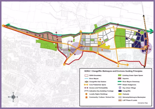
The guiding principles for the development of Clongriffin / Belmayne are set out below:
Urban Structure
The overall urban structure envisaged by the LAP (as indicated in the Belmayne Masterplan) is comprised of two Key Urban Villages (KUV), Clongriffin Train Station to the east and at Malahide Road (Clarehall / Northern Cross) to the west, connected by a Main Street boulevard, greenways and interspersed by a network of urban squares, parks and green spaces. In order to deliver the vision, key infrastructure is required to be delivered as set out below:
- Completion of Clongriffin KUV centre to include the development of key sites adjacent to the train station, east of Father Collins Park.
- Completion / upgrade of Belmayne Main Street in order to provide a strategic east-west connection, linking the Key Urban Village (KUV) centre at Clongriffin Railway Station Square to the Key Urban Village (KUV) centre at Belmayne Town Centre at Malahide Road, and facilitate high quality bus, cycle and pedestrian facilities. This street was approved by Dublin City Council under the Part 8 planning process and received funding from LIHAF. It will also incorporate Core Bus Corridor No. 1 from Clongriffin Railway Station to the city centre, under the BusConnects project. The completion of this link will open up lands for development and will facilitate the development of Belmayne Town Centre.
- Provision of Belmayne Town Centre at the intersection between Belmayne Main Street and Malahide Road, focused on a new town square at the western end of Main Street, and facilitating a mix of retail, commercial and leisure uses.
- Belmayne – Belcamp green link along Belmayne Main Street to the east and Belcamp Avenue to the west of Malahide Road, improving connections between the four quadrants of the Malahide Road junction, and providing a connection between the Town Centre and major areas of open space (Darndale Park to Father Collins Park), schools and other amenities.
- Provision of new link street - ‘Belcamp Parkway’ between Malahide Road and the R139, bypassing the R139/R107 junction, with new signalised access off Malahide Road, in order to reduce traffic through the town centre. This will facilitate the redesign of the R139/R107 junction to better cater for pedestrians and cyclists and public transport. It will also provide a key western access to the Belcamp Lane lands, facilitating future development.
- To facilitate the provision of further road infrastructure to the north of ‘Belcamp Parkway’ in accordance with the NTA Strategy for the Greater Dublin Area 2022-2042 and explore the feasibility of implementing the recommendations of the South Fingal Study, in order to enhance connections between Dublin City Council and Fingal County Council areas.
- To ensure that the future development on the Phase 6 LAP lands to the east, north of the R139, are considered in the context of the wider development of the Belcamp lands in Fingal County Council. Development shall provide connectivity, including pedestrian and cycle links. Development proposals will be required to facilitate the provision of the River Mayne Greenway, providing links to the east, and associated riparian strip / linear park. Existing hedgerows on the subject lands shall be retained and incorporated into the design and layout of future developments and be situated within the public realm.
- Provision of the River Mayne Greenway and Linear Park in order to link the SDRA lands to the existing/proposed coastal greenway, part of the strategic East Coast Trail, proving a key amenity corridor, facilitating walking and cycling, while protecting and enhancing the biodiversity value of this corridor.
- Enhance and improve connections between Clongriffin and Baldoyle/Stapolin lands across the railway line at Clongriffin Train Station and at the River Mayne, in coordination with Fingal County Council.
- Urban Form and Block Layouts shall be arranged in a perimeter block configuration and shall form a continuous urban edge with the street in order to create enclosure, provide passive surveillance and animation. Typical block widths shall generally be in the range of between 45-50 m (lower scale housing) to 55-60 m (higher scale apartments). This will enable suitable separation distances to be achieved between the rear of blocks, as well as providing for private open space.
Land Use & Activity
- A rich mix of uses to include retail, commercial, community, employment and residential uses will be sought on these lands, relative to the two KUV centres. At Belcamp the development will be primarily residential with a mix of typologies and tenures supported by community and social infrastructure. Commercial uses will be located along the Malahide Road and around the Town Squares at the Malahide Road junction.
- Residential densities shall be highest within the two KUV centres and along Main Street, in proximity to the train station at Clongriffin and along the proposed Core Bus Corridor.
- Provision for a post primary school site located at Belmayne Avenue and Main Street and adjacent to the greenway which links to Father Collins Park.
- Reserve a school site at Clongriffin, subject to the requirements of the Department of Education and Skills.
- Facilitate the relocation of allotments from the Belmayne Main Street site to a suitable location in the area.
Height
- Building heights shall respond to the proposed urban structure and land uses and activities. In general, the KUV centres at Belmayne Town Centre and Clongriffin Train Station shall contain the greatest building heights, in order to reinforce their status as a KUV, subject to amenity and design safeguards.
- Gateway buildings form a key structuring element, enhancing legibility and avoiding the proliferation of monolithic heights. As such, locally higher buildings shall be located within the KUV and along the Belmayne-Belcamp link, as illustrated.
- The following building heights shall be applied:
- Minimum heights of 5 storeys to the Key Urban Village centres at Clongriffin Rail Station and Belmayne Town Centre at the R139/R107 junction.
- Minimum heights of four to five storeys for Main Street Boulevard.
- A locally higher building adjacent to the rail station and at the junction of Malahide Road / R152.
- Any proposed height must have regard to existing neighbourhoods and character, in order to protect residential and visual amenity.
Design
- Architectural treatment shall be of the highest quality and allow for a range of building types and designs, creating a visually coherent urban form.
- Opportunities exist to establish a new architectural language in Belcamp that is distinct from Belmayne and Northern Cross, in order to enhance the legibility of the area.
Green Infrastructure
- The Belmayne-Belcamp Green link and River Mayne Greenway / linear park will provide key strategic green links connecting the SDRA to surrounding areas, enhancing the biodiversity value of existing green infrastructure, while integrating SUDS features.
- Existing hedgerows on the Phase 6 LAP lands form important biodiversity corridors and shall be retained and incorporated into the public realm of any future development proposals.
- Tree planting, landscaping and SuDS features will be integrated into the urban structure and movement framework for the SDRA lands. Key green links shall provide additional landscaping in order to accentuate their strategic importance as amenity, sustainable movement and biodiversity corridors.
- All future developments shall comply with the SuDS Strategy outlined in the 2020 Masterplan.
Figure 13-4: SDRA 1 Clongriffin/Belmayne and Environs